This item has been sold, but you can get on the Waitlist to be notified if another example becomes available, or purchase a digital scan.
1841 Bradford Map of North America w/ Republic of Texas
NorthAmerica-bradford-1841-2$475.00

Title
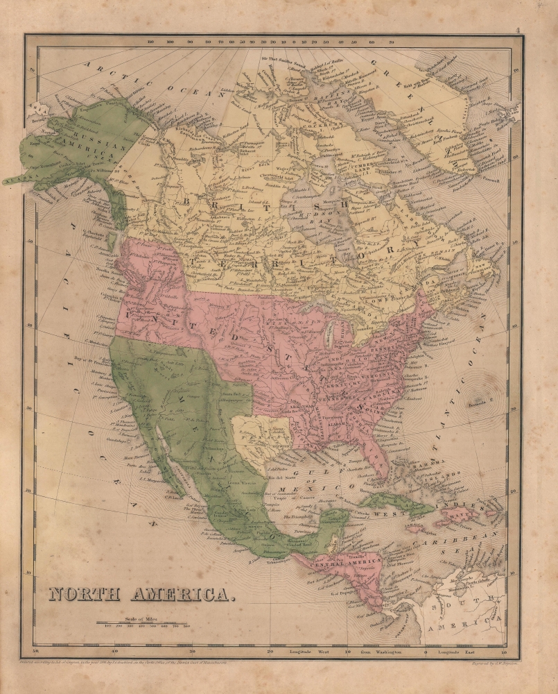
North America.
1841 (dated) 14.25 x 12 in (36.195 x 30.48 cm) 1 : 24000000
1841 (dated) 14.25 x 12 in (36.195 x 30.48 cm) 1 : 24000000
Description
A scarce map of North America by Thomas Bradford, made for inclusion in the 1841 edition of his A General Atlas of the World. It has several significant features, the most notable being the Republic of Texas and an expanded northwestern border of the United States.
A Closer Look
Coverage includes the United States, British Territories (including Canada), Russian America (Alaska), Mexico, Texas as a Republic, Central American states, the West Indies, and Greenland. Rivers and lakes are labeled in considerable detail, while mountains, cities, international borders, and individual U.S. states and British territories, among other features, are indicated. Perhaps unsurprisingly, the geography of the western part of North America includes some errors and apocryphal characteristics. However, the most noticeable elements of the map are the inclusion of the Republic of Texas and the northwestern border of the U.S.Republic of Texas
The Republic of Texas came into existence after Texas declared independence from Mexico in 1836. Following the revolution, Texas claimed the Rio Grande River as its southern border. The surrender treaties were never ratified by Mexico and the Mexicans disputed the southern border, stating that it was not the Rio Grande, but the Nueces River that created the boundary between the two nations. Intermittent hostilities continued until Texas was admitted into the United States in 1846. The U.S. inherited the border dispute, which had not been satisfied, and the dispute became one of the reasons for the Mexican-American War. Both the Rio Grande and Nueces Rivers are labeled on this map, and the coloring of Texas and Mexico clearly shows the fluidity of the border situation.54-40 or Fight!
Another intriguing attribute of this map is that the Pacific Northwest border of the United States is not depicted at the 49th parallel, which is the contemporary border between the United States and Canada, but rather at the parallel 54-40' north, which was the border with Russian America and well into modern-day British Columbia. The Oregon Question was disputed for decades between the United States and Great Britain. The basis for the dispute was mostly economic. The fur trade in the Pacific Northwest at this point in history was booming, which meant that both British and American companies and citizens wanted access to this area. American interest was also rooted in the concept of Manifest Destiny and the Westward Expansion. Although the border was set at the 49th parallel by 1846, the crisis was not fully resolved until 1872. It is apparent that this map was produced in the United States because American territory (shaded in pink) extends to the parallel 54-40' north.Publication History and Census
This map was engraved by George Washington Boynton for publication in Thomas G. Bradford’s 1841 edition of A General Atlas of the World. Despite being copyrighted as 1838, the clearer distinction of Texas and British Honduras, along with other minor differences, mark it out as the 1841 edition. Some examples of this map do not include the page number at top-right, but, in any event, it was the third map in Bradford's General Atlas after maps of the Western and Eastern Hemispheres. Whether dated 1838 or 1841, this map is not independently cataloged in the OCLC, and both the map and 1841 atlas are only held by the David Rumsey Historical Map Collection.CartographerS
Thomas Gamaliel Bradford (1802 - 1887) was born in Boston, Massachusetts, where he worked as an assistant editor for the Encyclopedia Americana. Bradford's first major cartographic work was his revision and subsequent republishing of an important French geography by Adrian Balbi, Abrege de Geographie published in America as Atlas Designed to Illustrate the Abridgment of Universal Geography, Modern and Ancient. Afterwards Bradford revised and expanded this work into his own important contributions to American cartography, the 1838 An Illustrated Atlas Geographical, Statistical and Historical of the United States and Adjacent Countries. Bradford's cartographic work is significant as among the first to record Texas as an independent nation. In his long career as a map publisher Bradford worked with William Davis Ticknor of Boston, Freeman Hunt of New York, Charles De Silver of Philadelphia, John Hinton, George Washington Boynton, and others. We have been able to discover little of Bradford's personal life. More by this mapmaker...
George Washington Boynton (fl. c. 1830 - 1850) was a Boston based cartographer and map engraver active in the first half of the 19th century. Boynton engraved and compiled maps for numerous publishers including Thomas Bradford, Nathaniel Dearborn, Daniel Adams, and S. G. Goodrich. His most significant work is most likely his engraving of various maps for Bradford's Illustrated Atlas, Geographical, Statistical, and Historical, of the United States and the Adjacent Countries and Universal Illustrated Atlas. He also engraved for the Boston Almanac. In 1835, Boynton is listed as an employee of the Boston Bewick Company, an engraving, stereotype, and printing concern based at no. 47 Court Street, Boston. Little else is known of his life. Learn More...
Source
Bradford, T. G. and Goodrich, S. G., A Universal Illustrated Atlas, exhibiting a Geographical, Statistical, and Historical view of the World, (Boston: Charles D. Strong) 1841.
The Universal Illustrated Atlas is one of the great American atlases of the first half of the 19th century. The atlas was first published in 1838 under the imprint of Charles D. Strong. It replaced and superseded Bradford's earlier smaller format Illustrated Atlas, Geographical, Statistical, and Historical, of the United States and the Adjacent Countries. Numerous reissues of the Universal Illustrated Atlas followed until about 1848. Although there are minor variations between the editions, most contain about 50 maps, the majority of which focus on the United States. Bradford's atlases are significant for recording North America during the Republic of Texas Era. In later editions, particularly the 1846 edition, Bradford illustrates the boom in railroad construction, possibly with the idea that his maps would aid travelers in planning journeys by rail. It was compiled by Thomas Gamaliel Bradford and Samuel Griswold Goodrich with most of the plates engraved by George Washington Boynton (fl. c. 1830 - 1850). Other contributors include Thomas Gordon (1778 - 1848), Fielding Lucas Jr. (1781 - 1854), Samuel Edward Stiles (1844 - 1901), Sherman and Smith (fl. c. 1829 - 1855), and Horace Thayer (1811 - c. 1874).
Condition
Good. Some toning and foxing.
References
Martin, James C. and Robert Sidney, Maps of Texas and the Southwest, 1513-1900 (Austin: Texas State Historical Association, 1999). Rumsey 4453.003. Philips (Atlases) 6092-4.