1814 Carey / Bower Map of North America
NorthAmerica-carey-1814$350.00

Title
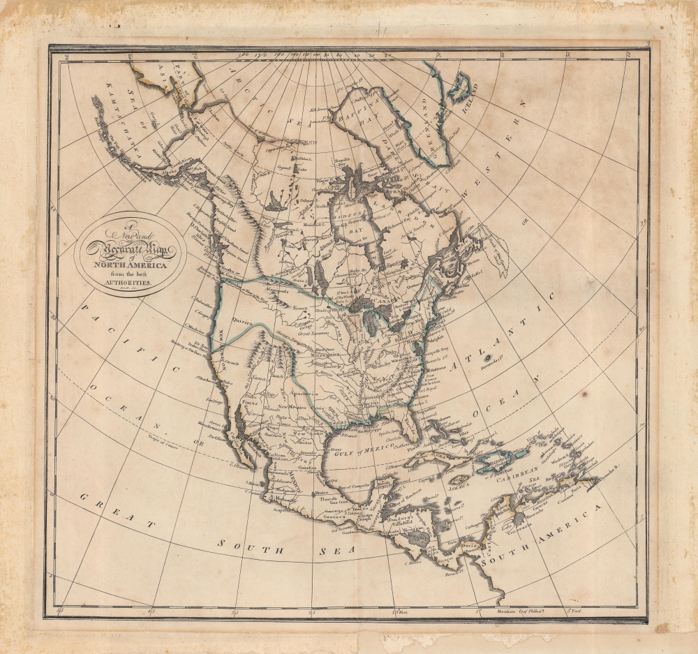
A New and Accurate Map of North America from the best Authorities.
1814 (undated) 14 x 14.75 in (35.56 x 37.465 cm) 1 : 26000000
1814 (undated) 14 x 14.75 in (35.56 x 37.465 cm) 1 : 26000000
Description
An interesting map of North America by Matthew Carey and engraved by John Bower for the 1814 edition of Carey's General Atlas. It reflects the state of geographical knowledge of interior North America at the start of the 19th century, before the discoveries of Lewis and Clark.
A Closer Look
This is a curious map, reflecting geographical discoveries of the late 18th century on the western coast of North America, including Perouse and Vancouver's expeditions, but not yet incorporating the discoveries of Lewis and Clark. Hence, the very long Columbia River as a 'River of the West' and the incomplete Rocky Mountains. Terminology dating as far back as the 16th century, such as Quivira, is retained here. The border between the Louisiana Territory and British claims in North America strikes the modern viewer as strange, as it was not fixed at this point; the London Convention of 1818 established the principle of using the 49th parallel north as a consistent border. Rivers, mountains, larger settlements, mountains, approximate borders, and several larger Native American groups are indicated throughout.Publication History and Census
This map was created and published by Mathew Carey and engraved by John Bower for the 1814 edition of Carey's General Atlas and appeared as the third map in the atlas, following the world in hemispheres and a chart of the world using a Mercator projection. Carey's General Atlas was the first atlas published in the United States to incorporate standardized color. Since OCLC listings sometimes combine digital and physical examples, complete census is difficult, but the physical map is certainly held by the University of Michigan, the Cincinnati Historical Library, the State Library of Pennsylvania, the University of Texas Austin, and the New York Public Library, while Carey's General Atlas is well-represented in institutional collections.CartographerS
Matthew Carey (January 28, 1760 - September 16, 1839) was a Dublin born publisher who established himself in Philadelphia in the late 18th and early 19th century. A young man of socially progressive views, Carey's first known publication, produced when he was but 17 years old, was a pamphlet criticizing dueling. Another pamphlet, issued in the same year, attacked the Irish penal code. Shortly afterwards, in 1779, legal issues, possibly arising from his liberal political activism, forced Carey to flee to Paris. In Paris, Carey had the good fortune to befriend the visiting American diplomat and founding father, Benjamin Franklin (1706 - 1790). As an Irishman chafing under the rule of England, Carey sympathized with and admired the American revolutionary. The liberally minded pair struck up a lifelong friendship and Carey was hired to work at Franklin's press in Passy, France. A year later, Carey returned to Ireland and resumed his politically provocative publishing career with The Freemans's Journal and The Volunteer's Journal. It didn't take long for political pressure to once again force Carey from Ireland - this time to America (1784). Although largely without funds, Carey convinced Gilbert du Motier, Marquis de Lafayette (1757 - 1834), who he knew from Franklin's Paris circle, to lend him funds to establish a new publishing concern in Philadelphia. Despite this loan, Carey's firm remained under financed and opened on a shoestring budget. It was most likely his limited budget that led Carey to some of his most important publishing innovations. At the time cartographic publishing was dominated by large printing houses in London and Paris where most, if not all, of the work was completed in house. Without the finances to emulate this large publishing houses, Carey was forced to outsource much of his publishing work. This set the stage for subsequent American publishers who, in order to compete effectively with European firms, relied on an often bewildering network of alliances and collaborations. Carey was also a master of republishing many of his own maps in multiple different atlases and formats to maximize their profitability. His most important work is without a doubt the 1795 issue of the American Atlas the first atlas to be published in America. Carey died in 1839 but was succeeded by his son Henry Charles Carey (1793 - 1879) who, in partnership with his brother-in-law Isaac Lea (1792 - 1886), published numerous important maps and atlases under the Carey and Lea, Lea Brothers, and Lea and Blanchard imprints. More by this mapmaker...
John Bower (fl. c. 1810 - 1819) was an engraver based in Philadelphia that produced plates for Carey's General Atlas, illustrations for a printing of Isaac Collins' Bible, as well as a depiction of the bombardment of Fort McHenry and portraits of the earliest U.S. Presidents. Learn More...
Source
Carey, M., Carey's General Atlas, (Philadelphia) 1814.
Condition
Good. Marginal mends not impacting printed image. General margin discoloration due to earlier framing.
References
Rumsey 4577.003. OCLC 852833359, 14639845.