1806 Darton and Harvey Map of North America
NorthAmerica-dartonsr-1806$750.00

Title
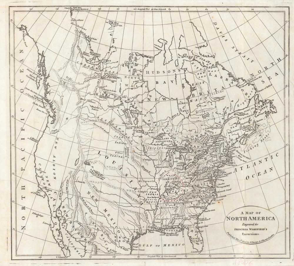
A Map of North America, Engraved for Priscilla Wakefield's Excursions.
1806 (dated) 14 x 15.5 in (35.56 x 39.37 cm) 1 : 15600000
1806 (dated) 14 x 15.5 in (35.56 x 39.37 cm) 1 : 15600000
Description
An engaging 1806 map of North America published in Priscilla Wakefield's Excursions in North America (London: Darton and Harvey), a work of fiction describing a journey through the continent. It provides a concise summation of contemporary geographic knowledge about the continent, along with some speculative and fanciful elements.
Though engraved for a work of fiction, the map was quite up-to-date, reflecting geographical knowledge of the continent before the publication of the findings of Lewis and Clark's Expedition. The western coast of North America conforms with the discoveries of La Perouse, Cook, and Vancouver, among others. Naturally, the interior parts of the western half of the continent are more speculative, though in some places quite prescient, especially the upper reaches of the Missouri River.
Written in epistolary fashion as a sequel to an earlier, similar book about travels in Europe, Excursions is a curious work in several respects. Wakefield had never visited the continent and admits to relying upon accounts written by explorers and intellectuals, such as Alexander Mackenzie and Thomas Jefferson. Given her interest in the natural sciences, the book devotes considerable attention to the continent's flora and fauna. Extensive descriptions are also made of the various Native American tribes encountered and their interactions with White settlers, including one chapter recounting battles from the perspective of an Indian chief.
A Closer Look
The North American continent as it was known at the time is displayed, with towns, cities, waterways, mountains, and the borders between U.S. states indicated. Native American tribes, sometimes misplaced or invented, are listed in detail. A thin red circle is drawn around the western portion of the Ohio River, presumably in relation to the plot of the novel.Though engraved for a work of fiction, the map was quite up-to-date, reflecting geographical knowledge of the continent before the publication of the findings of Lewis and Clark's Expedition. The western coast of North America conforms with the discoveries of La Perouse, Cook, and Vancouver, among others. Naturally, the interior parts of the western half of the continent are more speculative, though in some places quite prescient, especially the upper reaches of the Missouri River.
Priscilla Wakefield and the Excursions
Priscilla Wakefield (1751 - 1832) was a remarkable figure whose writings spanned the fields of the sciences, economics, and social welfare. As a philanthropist and social commentator, she brought attention to the difficult situation of women and children in British society and sought a more equitable role for women. She also published works on botany, entomology, and didactic guides for children, among other topics. But she was perhaps most popular in her time for works of imagined travel.Written in epistolary fashion as a sequel to an earlier, similar book about travels in Europe, Excursions is a curious work in several respects. Wakefield had never visited the continent and admits to relying upon accounts written by explorers and intellectuals, such as Alexander Mackenzie and Thomas Jefferson. Given her interest in the natural sciences, the book devotes considerable attention to the continent's flora and fauna. Extensive descriptions are also made of the various Native American tribes encountered and their interactions with White settlers, including one chapter recounting battles from the perspective of an Indian chief.
Publication History and Census
This map was engraved by an unnamed engraver (perhaps Darton) for Priscilla Wakefield's Excursions in North America: Described in Letters from a Gentleman and His Young Companion, to Their Friends in England, published in London by Darton and Harvey in 1806 (like Wakefield, William Darton and Joseph Harvey were Quakers). It is not independently cataloged among the holdings of any institution, while the entire Excursions (OCLC 933188851) is only listed among the holdings of Queen's University and the New-York Historical Society.Cartographer
William Darton, Sr. (1755 - 1819) was a British printer, engraver, and publisher based in London who specialized in the publication of children's books. Establishing himself as a printer and engraver in 1787, Darton entered into a partnership with Joseph Harvey in 1791, after which they published as 'Darton and Harvey.' As both men were Quakers, they initially tended to focus on publishing works by fellow Quakers, but later developed a specialty in children's literature. The firm's name changed several times as sons of both men joined as partners and the founding members died off. Darton's descendants continued to work in the publishing industry, with his son William, Jr., establishing his own shop in 1804. More by this mapmaker...
Condition
Good. Verso repair to tear at right. Creasing along fold lines. Light foxing in a few spots.