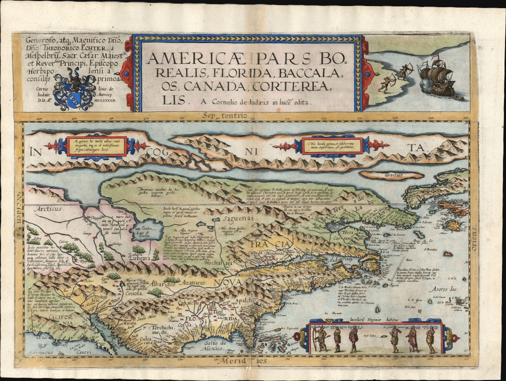
1593 Cornelis De Jode Map of North America
NorthAmerica-dejode-1593$37,500.00


Title
Americae Pars Borealis, Florida, Baccalaos, Canada, Corterealis.
1593 (dated) 14.5 x 20 in (36.83 x 50.8 cm) 1 : 28500000
1593 (dated) 14.5 x 20 in (36.83 x 50.8 cm) 1 : 28500000
Description
This is Cornelis De Jode's rare map of North America, printed in a single edition of 1593. The first full-size folio map specifically of North America, it was among the updated maps added to the De Jode atlas specifically to compete with Ortelius' Theatrum Orbis Terrarum. To this end, it combined cartographic information from current sources with a level of decorative flourish that had not yet appeared in any atlas. In the case of this map, Cornelis focused on a part of the world omitted from the elder De Jode's 1578 atlas.
De Jode's map is also an important Floridianum: it was the first general map to name 'St. Augustine,' preceded by only one other printed map of any kind, the 1589 Batista Boazio map.
In the north (beyond a largely imaginary northeast) is a prominent St. Lawrence River, including the settlement of Hochelaga, at present-day Montreal. The river's sources lie deep within the continent, although there is no indication of the Great Lakes. Newfoundland can be recognized, termed Terra de Baccalao [Land of Cod].
A Closer Look
The map presents North America on a cylindrical projection from the Tropic of Cancer to 90° north, thus spanning from Florida, the northern Gulf Coast, and most of Baja California, well up into the Arctic; the map reaches from a highly speculative California in the west, to beyond the Canadian Maritimes in the east. Coverage extends far enough to the east to include the Azores islands and (in the north) Iceland, Greenland, and Nicolo Zeno's phantom islands of Frisland, Icaria, and Drogeo. It also features a prominent Northwest Passage.A Wealth of Descriptive Detail, Richly Embellished
Cornelis understood that improved detail alone would be insufficient to challenge Ortelius' market dominance. He thus anticipated the mapmakers of the Dutch Golden Age by elaborating his maps with graphic imagery to better illustrate the relevant subject areas. Here, in the upper right, native warriors pull bows to threaten a European ship approaching the coast, cannons ablaze. In a cartouche at the lower right are six figures representing Virginian natives. An elegant dedication to the Dutch bishop Theodorus Echter is in the upper left. The map itself is beautifully engraved, with abundant pictorial forests and mountains. In addition to the finely engraved place names, De Jode includes Latin descriptions of key North American discoveries of the 16th century and descriptions of the Indigenous population.Updating the De Jode Atlas
In order to produce the new continent maps for his 1593 atlas, Cornelis drew on the cartography of Peter Plancius' 1592 wall map of the world, Nova et Exacta Terrarum Orbis Tabula Geographica ac Hydrographica. The east-west distortion on each of Cornelis' new maps reflects Plancius' cylindrical projection. Plancius was a veritable clearinghouse of geographic information, so the younger De Jode's choice of source was canny. The present work thus encapsulates a unique and state-of-the-art view of the northern part of the Americas at the dawn of the European colonial era.Mapping The East Coast
This is one of the first general maps to use the place name 'Virginia,' preceded only by the unobtainable Western Hemisphere maps of Hakluyt, Mazza, and Hogenberg. It is remarkable that, while the coastline and other placenames can all be found on the 1592 Plancius, that map did not include the name 'Virginia.' Its presence here indicates that De Jode was not slavishly copying Plancius and was alert to contemporary geographical developments. Also, De Jode includes a brief history of the Roanoke Colony, containing a rosy account of the region's resources: this, too, did not appear on the Plancius and is an important revision.De Jode's map is also an important Floridianum: it was the first general map to name 'St. Augustine,' preceded by only one other printed map of any kind, the 1589 Batista Boazio map.
In the north (beyond a largely imaginary northeast) is a prominent St. Lawrence River, including the settlement of Hochelaga, at present-day Montreal. The river's sources lie deep within the continent, although there is no indication of the Great Lakes. Newfoundland can be recognized, termed Terra de Baccalao [Land of Cod].
The Zeno Cartography
Iceland and Greenland appear at the upper right, accompanied by the phantom islands of Frisland, Icaria, and Drogeo, all hailing from the fraudulent 1558 map of Nicolo Zeno, whose cartography was embraced by Plancius, Mercator, and Ortelius. As with these luminaries, Plancius supposed that Zeno's placename Estotiland applied to the northeastern Labrador coast, as does De Jode here. (It had been portrayed ambiguously on the 1558 Zeno and on Ruscelli's 1561 edition.)The Southwest
While the map's depiction of Baja California and northern Mexico appears generally accurate, all points north are extremely speculative. A river Coromara, similar to the Colorado, snakes northeast from the Golfo Vermeiro, where it reaches Coronado's sought-after Seven Cities of Gold; a Latin note here reports 'Marcos de Niza had said that the province of the seven cities was very noble.' (Niza accompanied Coronado in 1538.)War of Maps
Despite surpassing both Ortelius' and Gerard De Jode's maps in terms of accuracy and beauty, this map appeared only in the second and final 1593 edition of Gerard and Cornelis De Jode's Speculum Orbis Terrarum. The Speculum was unable to break Ortelius' lock on the market and was printed in only one edition. After Cornelis died in 1600, Jan Baptist Vrients (who was publishing Ortelius' atlas) purchased the De Jode plates and suppressed them (likely destroyed). There were thus no later printings of De Jode's maps.Publication History and Census
This map is rare. It was engraved for inclusion in Cornelis De Jode's 1593 Speculum Orbis Terrae. The map was not reprinted, the plates having been acquired from De Jode's widow by Ortelius' executor, Vrients, and destroyed to remove them from the market. This separate map appears in perhaps 20 institutions, according to OCLC. About a dozen examples of the Speculum appear in institutional collections.CartographerS
Cornelis de Jode (1568 – October 17, 1600) was an Antwerp cartographer, engraver and publisher, He was the son and heir of Gerard de Jode, also a cartographer and publisher. Cornelis studied science at Academy of Douai, but it can be understood that his main education in the trade was at the hands of his father. On his father's death in 1591, Cornelis de Jode took over the work on his father's atlas, Speculum Orbis Terrarum. This had enjoyed publication in a single edition of 1578, overshadowed by the competition posed by Abraham Ortelius' (1527 - 1598) Theatrum Orbis Terrrum. Cornelis published a second edition, to which he added many updated maps to bring the work up to date with its competition. Despite the improvements brought to the atlas, both aesthetic and geographic, De Jode was unable to break Ortelius' grip on the market and there were no further editions of the atlas. After his death, the engraving plates were sold to Ortelius' executor Johannes Baptista Vrients (1552 - 1612), who was continuing to publish the Theatrum. Vrients would utilize several decorative plates from the Speculum, but the complete work and its maps were not published again - likely they were destroyed by Vrients to keep them from competing with his editions of the i>Theatrum. More by this mapmaker...
Petrus Plancius (1522 - May 15, 1622) was a Dutch-Flemish cartographer, astronomer, and clergyman. Born in Dranouter, he studied theology in Germany and England. He became a minister in the Dutch Reformed Church at the age of 24. In 1585, fearing religious prosecution by the Inquisition after Brussels fell into Spanish hands, Plancius fled to Amsterdam. It was in Amsterdam that he became interested in navigation and cartography and soon became a recognized expert on the shipping routes to India. Plancius published his best known world map in 1592, entitled ‘Nova et exacta Terrarum Tabula geographic et hydrographica’. Plancius was also one of the founders of the Dutch East India Company, for which he drew over 100 maps. Learn More...
Source
De Jode, Cornelis, Speculum Orbis Terrarum, (Antwerp: Arnold Coninx) 1593.
Gerard De Jode (1516/17 - 1591) first issued his spectacular atlas, the Speculum Orbis Terrae, in Antwerp in 1578. The atlas was intended to compete with Abraham Ortelius' Theatrum Orbis Terrarum, and as such, was a lavish production, beautifully engraved and compiled from the best cartography of the period. De Jode drew from such illustrious sources as G. Gastaldi, Pirro Ligorio, Alvaro Seco, Lieven Algoet, Heinrich Zell, Wolfgang Lazius, Augustin Hirsvogel, Sebastian Rotenhan, Aegidius Tschudi, Bartholomaeus Scultetus, and Caspar Vopel. Like due to his lack of political connects and general business acumen, De Jode's Speculum never attained the widespread popularity of Ortelius' Theatrum. When Gerard died in 1591, the firm was taken over by his son, Cornelis de Jode (1568 - 1600) and, his wife, Paschina. C. De Jode partnered with Arnold Coninx to publish a new edition of the Speculum Orbis Terrae in 1593. Cornelius died young at 32, and the De Jode stock was sold to Johannes Baptista Vrients (1552 - 1612). Vrients had earlier acquired Ortelius's map plates and was actively republishing them. He did not similarly republish the Speculum Orbis Terrae; rather, his purchase of the De Jode plates was intended to keep them off the market. Most were destroyed at his hands, resulting in them never being reprinted and being exceptionally scarce today.
Condition
Very good. Mend to bottom centerfold with some reinstated wormholing. Tallow stain to left border. Faint offsetting. Else a beautiful, full-margined example.
References
OCLC 76701470. Burden, P., The Mapping of North America, #81.