This item has been sold, but you can get on the Waitlist to be notified if another example becomes available, or purchase a digital scan.
1860 Johnson Map of North America
NorthAmerica-johnson-1860$150.00

Title
Johnson's North America.
1860 (undated) 22.5 x 18 in (57.15 x 45.72 cm) 1 : 15840000
1860 (undated) 22.5 x 18 in (57.15 x 45.72 cm) 1 : 15840000
Description
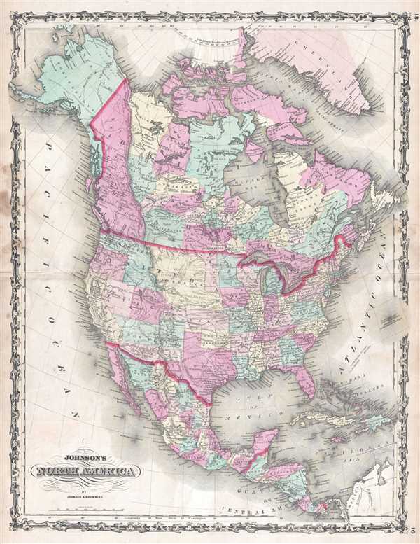
This is a beautiful example of A. J. Johnson and Ross C. Browning's 1860 first edition map of North America. The map depicts the continent from the Pacific Ocean to the Atlantic Ocean and from the Arctic Ocean and Greenland to the Bay of Panama and South America. Created just before the outbreak of the American Civil War, Johnson's map captures a unique moment in American history, both geographically and politically. Of particular interest is the geography of the western part of the United States, where the boundaries of several territories were still undecided. By 1865, the American West would look much different than it does here in 1860.
Other territorial boundaries in the western United States that do not conform with today's states are illustrated as they were laid out upon the territory's creation. Both the Utah Territory and the Washington Territory were created just as they are illustrated here. West Virginia, in the east, would not come into existence until until 1862, after it seceded from Virginia because its citizens disagreed with seceding from the Union.
On a more general note, each state that had been admitted to the Union by 18606 is illustrated, labeled, and shaded a different color to allow for easy differentiation. State capitals are labeled, along with numerous other cities and towns throughout the country. The rail network is also depicted and would play a key role in the coming war between the Union and the Confederacy. Several Native American tribes are named west of the Mississippi River, including the Pawnee, Crow, Navajo, and Apache.
Outside the United States, Canada is illustrated as a collection of regions and provinces and would not begin to unite until the Canadian Confederation of 1867. Alaska is labeled as 'Russian Possessions', as this map predates the American purchase of Alaska from Russia. Each of the different countries in Central America are illustrated and labeled, and states are labeled and shaded different colors in Mexico.
The whole is surrounded by the strapwork border used for Johnson's atlas maps from 1860 to 1863. Published by A. J. Johnson and Ross C. Browning as plate nos. 15 and 16 in the 1860 first edition edition of Johnson's New Illustrated Family Atlas.
Nebraska Territory at its Fullest
When examining the American West as illustrated here, one of the first differences that is immediately apparent is the configuration of the Nebraska Territory. This massive Nebraska territory, incorporated in May of 1854, included most of the northern Great Plains, much of the Missouri River Basin, and the eastern part of the northern Rocky Mountains, the most land the territory would ever incorporate. By 1861, a year after this map appeared, Nebraska Territory would be significantly reduced by the formations of Colorado and Dakota Territories.The Unincorporated Territory of 'Dacotah'
During the nearly three year period between Minnesota's statehood on May 11, 1858 and the creation of the Dakota Territory in March 2, 1861, the portion of what had been the Minnesota Territory that fell between the Missouri River and Red River, Minnesota's newly-created western border, remained unattached to any official territory of the United States. Immediately following Minnesota's statehood, a provisional government was set up in the Pembina Region which lobbied for recognition as a territory. In doing so, a formally recognized local government would be in place, which is an important part of encouraging settlement in a region. Even so, the proposal was mostly ignored by the Federal government until the Dakota Territory was formed, which upon its creation included most of present-day Montana, Wyoming, and both North and South Dakota.The Proposed Arizona Territory
Arizona would not be admitted into the Union until February 24, 1863, with very similar borders to the modern-day state. Here, the Arizona Territory is illustrated as it was proposed to Congress in late 1860, as a last-ditch attempt to avoid the American Civil War. The proposal never passed, however, because most of the members of Congress from southern states had already left Congress following declarations of secession. An Arizona Territory with these borders did secede from the New Mexico Territory in 1861 and joined the Confederacy but was soon recaptured by Union forces from California. Before creating the Arizona Territory, it was decided that the New Mexico Territory would be divided by a vertical border, so that both territories would benefit from the proposed transcontinental Southern Pacific Railraod.Other territorial boundaries in the western United States that do not conform with today's states are illustrated as they were laid out upon the territory's creation. Both the Utah Territory and the Washington Territory were created just as they are illustrated here. West Virginia, in the east, would not come into existence until until 1862, after it seceded from Virginia because its citizens disagreed with seceding from the Union.
On a more general note, each state that had been admitted to the Union by 18606 is illustrated, labeled, and shaded a different color to allow for easy differentiation. State capitals are labeled, along with numerous other cities and towns throughout the country. The rail network is also depicted and would play a key role in the coming war between the Union and the Confederacy. Several Native American tribes are named west of the Mississippi River, including the Pawnee, Crow, Navajo, and Apache.
Outside the United States, Canada is illustrated as a collection of regions and provinces and would not begin to unite until the Canadian Confederation of 1867. Alaska is labeled as 'Russian Possessions', as this map predates the American purchase of Alaska from Russia. Each of the different countries in Central America are illustrated and labeled, and states are labeled and shaded different colors in Mexico.
The whole is surrounded by the strapwork border used for Johnson's atlas maps from 1860 to 1863. Published by A. J. Johnson and Ross C. Browning as plate nos. 15 and 16 in the 1860 first edition edition of Johnson's New Illustrated Family Atlas.
Cartographer
Alvin Jewett Johnson (September 23, 1827 - April 22, 1884) was a prolific American map publisher active from 1856 to the mid-1880s. Johnson was born into a poor family in Wallingford, Vermont, where he received only a basic public education. He is known to have worked as a school teacher for several years before moving to Richmond, Virginia. Johnson got his first taste of the map business as a salesman and book canvasser for J. H. Colton. The earliest Johnson maps were published with D. Griffing Johnson (no clear relation) and date to the mid-1850s; however, it was not until 1860 that the Johnson firm published its first significant work, the Johnson's New Illustrated (Steel Plate) Family Atlas. The publication of the Family Atlas followed a somewhat mysterious 1859 deal with the well-established but financially strapped J. H. Colton cartographic publishing firm. Although map historian Water Ristow speculates that Colton sold his copyrights to Johnson and his business partner, another Vermonter named Ross C. Browning (1822 - 1899), a more likely theory is that Johnson and Browning financially supported the Colton firm in exchange for the right to use Colton's existing copyrighted map plates. Regardless of which scenario actually occurred, it is indisputable that the first Johnson atlas maps were essentially reissues of earlier Colton maps. Early on, Johnson described his firm as the 'Successors to J. H. Colton and Company'. Johnson's business strategy involved transferring the original Colton steel plate engravings to cheaper lithographic stones, allowing his firm to produce more maps at a lower price point. In 1861, following the outbreak of the American Civil War (1861 - 1865) Johnson and Browning split their firm between two offices. Johnson moved from Richmond, Virginia, to New York City. Browning remained in Richmond, where he published at least one more edition of the atlas in 1862, at the height of the war. Johnson and Browning published two editions of the Johnson Atlas: 1860 (Richmond and New York) and 1861 (Richmond and New York). Sometime in 1861, Browning's portion of the firm (or perhaps the New York portion?) was purchased by Benjamin P. Ward, whose name subsequently replaced Browning's on the imprint. The 1863 issue of the Family Atlas was one of the most unusual, it being a compilation of older 'Johnson and Browning' maps, updated 1862 'Johnson and Ward' maps, and newer 1863 maps with a revised border design. The 1864 issue of the Family Atlas is the first fully 'Johnson and Ward' atlas. Johnson published one more edition of the atlas in partnership with Ward in 1865, after which Johnson bought out Ward. The next issue of the atlas, 1866, is the first purely 'Johnson' atlas with all new map plates, updated imprints, and copyrights. The Family Atlas went through roughly 27 years of publication, from 1860 to 1887, outliving Johnson himself, who died in 1884. Johnson maps from the Family Atlas are notable for their unique borders, of which there are four different designs, the 'strapwork border' from 1860 to 1863, the 'fretwork border' from 1863 to 1869, the 'spirograph border' in 1870 to 1882, and a more elaborate version of the same from 1880 to 1887. In addition to the Family Atlas, Johnson issued numerous wall maps, pocket maps, and in the 1880s, the Cyclopedia. Johnson maps are known for their size, accuracy, detail, and stunning, vivid hand coloring. Johnson's maps, purely American in their style and execution, chronicle some of the most important periods in American history, including the Civil War, the Westward Expansion, and the Indian Wars. Today Johnson's maps, especially those of the American West, are highly sought after by map collectors and historians. More by this mapmaker...
Source
Johnson, A. J., Johnson's New Illustrated (Steel Plate) Family Atlas, With Descriptions, Geographical, Statistical, And Historical. , (New York: Johnson and Browning) 1860.
Johnson's New Illustrated Family Atlas was produced in numerous editions from about 1860 to 1887. Johnson's first atlas was mostly likely the 1859 edition of Colton's General Atlas which both aesthetically and comprehensively very similar to the 1860 first edition of the New Illustrated Family Atlas. Johnson's atlas was noteworthy in its day as one of the few commercially produced American atlases that could compete with more established European Atlases. Although he called the atlas 'Steel Plate' on the title page for marketing purposes, Johnson in fact incorporated modern lithographic printing techniques and lower quality woven wood pulp paper to economically produce large format maps in quantity. He also began publishing the New Illustrated Family Atlas on the cusp of the American Civil War, a decision that proved fortuitous, as the war corresponded to a general increased interested in cartography. For the most part, Johnson's Atlas was sold by subscription; nonetheless it became so popular that for at time he was considered the largest publisher in the world. Other than the first edition, the atlas itself has no true editions. Rather, Johnson incorporated updated maps as they became available, so each example of the Johnson atlas might well contain unexpected and scarce individual maps. Johnson's map of the American Southwest, for example, appeared in more than 17 different states, each illustrating minor variations to the rapidly chasing geography of that region. Moreover, Johnson's offered a service whereby he would mail updated map pages that could be tipped into older atlases to keep them current. Generally speaking, Johnson's atlas was issued in four periods - each defined by a distinctive decorative border. The earliest edition featured a strapwork border that appears as rolled and decoratively cut leather. This border work remained in use until 1863. In 1864 Johnson started using an updated fretwork or grillwork border that resembles worked iron - as in a decorative fence. This border was in use from 1863 to 1869. The 1863 edition of Johnson's atlas used both borders and is considered transitional. From 1870 to 1882, Johnson introduced a new border that featured elaborate Spirograph style geometric designs, which was used from 1870 to 1882. After 1880 a new border different but aesthetically similar to the Spirograph border began appearing. Certain editions of the atlas issued from 1880 - 1882 were transitional.
Condition
Very good. Even overall toning. Light wear along original centerfold. Verso repairs to centerfold separations. Some soiling and foxing. Blank on verso.
References
Rumsey 2905.006.