
1949 Rand McNally Wall Map of North America

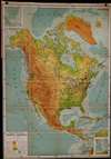


Ranally physical-political North America.
From the North Pole to the Panama Canal.
- Digital Map Information
- Suitable for large format printing
- File Size: 1560.55 MB
- File Type: ZIP / TIFF
- ICC color profile embedded
- Delivered instantly via download link
From the North Pole to the Panama Canal.
Here is a large-scale linen-backed folding wall map of North America produced by Rand McNally and Co. c. 1949. Both attractive and comprehensive, it combines political, topographical, and other information in a style characteristic of the 'Ranally' series produced in the mid-20th century.A Closer Look
This is a versatile map in every sense. It can be folded onto itself and carried in one arm but also has grommets installed at the top corners for wall hanging. It includes a wide variety of information on political boundaries, cities, transportation, topography, and maritime navigation (a notable feature is the inclusion of ocean depths).Insets are provided at top-left and at bottom-right, respectively depicting the Aleutian Islands and Puerto Rico with the Lesser Antilles. The provinces of Canada and the states and territories of the U.S. and Mexico are indicated.
The map employs Lambert azimuthal equal area projection, with a point of tangency located near Bismarck, North Dakota, at roughly the mid-point of the continent. This projection is especially well-suited to the mapping of hemispheres and continents (as opposed to the entire globe).
Publication History and Census
This map was produced by Rand-McNally in or around the year 1949, number 'RB100' in the Ranally series of the company's political-physical maps. It is only cataloged among the holdings of the University of Denver and Syracuse University, and is scarce to the market.Cartographer
Rand, McNally and Co. (fl. 1856 - present) is an American publisher of maps, atlases and globes. The company was founded in 1856 when William H. Rand, a native of Quincy, Massachusetts, opened a print shop in Chicago. Rand hired the recent Irish immigrant Andrew McNally to assist in the shop giving him a wage of 9 USD per week. The duo landed several important contracts, including the Tribune's (later renamed the Chicago Tribune) printing operation. In 1872, Rand McNally produced its first map, a railroad guide, using a new cost effective printing technique known as wax process engraving. As Chicago developed as a railway hub, the Rand firm, now incorporated as Rand McNally, began producing a wide array of railroad maps and guides. Over time, the firm expanded into atlases, globes, educational material, and general literature. By embracing the wax engraving process, Rand McNally was able to dominate the map and atlas market, pushing more traditional American lithographic publishers like Colton, Johnson, and Mitchell out of business. Eventually Rand McNally opened an annex office in New York City headed by Caleb S. Hammond, whose name is today synonymous with maps and atlases, and who later started his own map company, C. S. Hammond & Co. Both firms remain in business. Further Details...
Condition
Very good. Dissected and laid on linen. Some discoloration at top margin and top-left.
References
OCLC 933302618.