This item has been sold, but you can get on the Waitlist to be notified if another example becomes available, or purchase a digital scan.
1659 Nicolas Sanson Map of North America
NorthAmerica-sanson-1659$1,500.00

Title
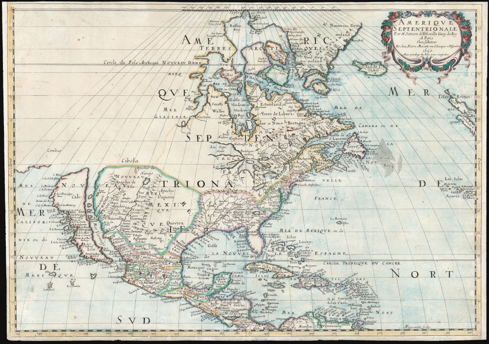
Amerique Septentrionale Par N. Sanson d'Abbeville Geog. du Roy A Paris Chez l'Auteur Et chez Pierre Mariette rue S. Jacques a lEsperāce 1650. Avec privilege du Roy pour vingt Ans.
1659 (dated) 15.5 x 21.75 in (39.37 x 55.245 cm) 1 : 20555000
1659 (dated) 15.5 x 21.75 in (39.37 x 55.245 cm) 1 : 20555000
Description
This is Sanson's map of North America, in its 1659 third state. Sanson’s was one of the first maps to reflect the increasing dominance of French exploration and cartography in the New World. It is among the earliest maps to show all five Great Lakes recognizably, and the first to name Superior and Ontario. It is also significant for being the first map to locate Santa Fe, and to note the existence and location of the Apache and Navajo tribes in the American southwest.
State of the Art Southern Geography
In its general form, Sanson’s mapping of Mexico and Central America does not deviate from the Dutch mapping of these regions. His placement of the Apaches de Navajo and the Apaches de Xila was novel, and the abundance of placenames here surpassed an work coming out of Amsterdam. Sanson’s map is the first to name Santa Fe on the Rio del Norte, although like his precursors Sanson has this river flowing not to the Gulf of Mexico but westwards to the Sea of California (Mar Vermejo). An imaginary mountain range wrapping from Virginia to the Gulf of Mexico, thus enclosing Spanish Florida, creates expansive watershed emptying into the Gulf of Mexico via a B. de Spiritus Sto. The mountain range curtails even the largest of these rivers, none of which can be construed as an analog to the Mississippi, which would not appear on a map until the 1683 Hennepin.If Messieur Sanson Says it is an Island…
This map was among the first published in France to depict California as an island, an error that had primarily been made by the mapmakers of England and the Netherlands beginning in 1624. Sanson, as Geographer to the French King, commanded great prestige; his adoption of an insular California served to cement that gaffe in European cartography for the rest of the century. Even after exploration confirmed that California was indeed part of mainland North America, mapmakers continued propagating the myth throughout the 18th century.Of the Utmost Importance
The combination of this insular California with the map's New Mexico geography make this map a Western Americanum of the utmost importance. Wheat writes,Sanson’s 1650 map of North America and 1656 map of New Mexico seem to the present writer by far the most interesting and important maps - so far as what is now western United States is concerned - that had appeared since Enrico Martínez drew his little ‘sketch’ of Oñate’s route to Quivira in 1602 - and this despite their manifest deficiencies and their retention of much of the older mythical geography.
The Great Lakes
Sanson's map is the first to recognizably portray all five of the Great Lakes, and it is the first to name Lakes Superior and Ontario. This 1659 state of the map corrected an engraving error on the earlier two: Lake Ontario on these earlier maps lacked hachure on the coastlines, creating the impression of an odd rosette of rivers rather than a body of water. Thus, the present state is the first map to present a named, clearly depicted Lake Ontario.Publication History and Census
This map was engraved by Abraham Peyrounin for separate publication, and for later inclusion in Les Cartes Generales de Toutes le Parties du Monde, the atlas jointly published by Nicolas Sanson and Pierre Mariette. The map exists in three states, of which this is the third, printed in 1659. The map is, overall, well represented in institutional collections. This third state is only listed twice in OCLC.Cartographer
Nicolas Sanson (December 20, 1600 - July 7, 1667) and his descendants were the most influential French cartographers of the 17th century and laid the groundwork for the Golden Age of French Cartography. Sanson was born in Picardy, but his family was of Scottish Descent. He studied with the Jesuit Fathers at Amiens. Sanson started his career as a historian where, it is said, he turned to cartography as a way to illustrate his historical studies. In the course of his research some of his fine maps came to the attention of King Louis XIII who, admiring the quality of his work, appointed Sanson Geographe Ordinaire du Roi. Sanson's duties in this coveted position included advising the king on matters of geography and compiling the royal cartographic archive. In 1644, he partnered with Pierre Mariette, an established print dealer and engraver, whose business savvy and ready capital enabled Sanson to publish an enormous quantity of maps. Sanson's corpus of some three hundred maps initiated the golden age of French mapmaking and he is considered the 'Father of French Cartography.' His work is distinguished as being the first of the 'Positivist Cartographers,' a primarily French school of cartography that valued scientific observation over historical cartographic conventions. The practice result of the is less embellishment of geographical imagery, as was common in the Dutch Golden Age maps of the 16th century, in favor of conventionalized cartographic representational modes. Sanson is most admired for his construction of the magnificent atlas Cartes Generales de Toutes les Parties du Monde. Sanson's maps of North America, Amerique Septentrionale (1650), Le Nouveau Mexique et La Floride (1656), and La Canada ou Nouvelle France (1656) are exceptionally notable for their important contributions to the cartographic perceptions of the New World. Both maps utilize the discoveries of important French missionaries and are among the first published maps to show the Great Lakes in recognizable form. Sanson was also an active proponent of the insular California theory, wherein it was speculated that California was an island rather than a peninsula. After his death, Sanson's maps were frequently republished, without updates, by his sons, Guillaume (1633 - 1703) and Adrien Sanson (1639 - 1718). Even so, Sanson's true cartographic legacy as a 'positivist geographer' was carried on by others, including Alexis-Hubert Jaillot, Guillaume De L'Isle, Gilles Robert de Vaugondy, and Pierre Duval. More by this mapmaker...
Condition
Fair. Mended tear from right border (near Azores) to coastline, with virtually no loss. Few marginal mends, else very good.
References
OCLC 166635431. Burden, P., The Mapping of America, #294, State 3. McLaughlin, G., The Mapping of California as an Island ,#12, State 3.