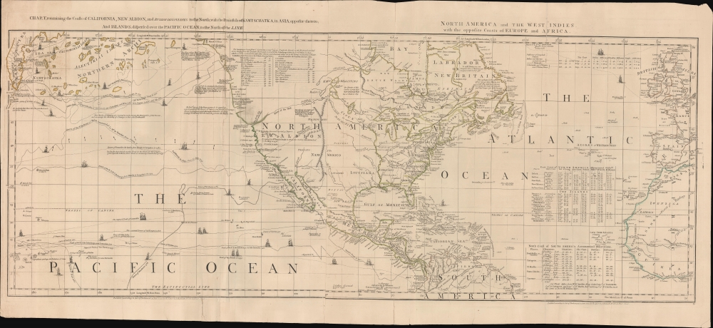
1775 Sayer and Bennet / Braddock Mead Map of North America
NorthAmerica-sayerbennett-1775$1,500.00


Title
Chart, containing the Coasts of California, New Albion, and Russian Discoveries to the North; with the Peninsula of Kamtschatka, in Asia, opposite thereto; and Islands, dispersed over the Pacific Ocean, to the north of the Line.
1775 (dated) 20 x 45 in (50.8 x 114.3 cm) 1 : 21000000
1775 (dated) 20 x 45 in (50.8 x 114.3 cm) 1 : 21000000
Description
A 1775 map of North America by John Green, also known as Braddock Mead. The map is a masterpiece of late 18th-century cartography by one of the least understood and most controversial cartographers of his age. Mead composed the map in protest to what he considered the flagrantly spurious and irresponsible cartography of Frenchmen Joseph-Nicolas De l'Isle (1688 - 1768) and Phillipe Buache (1700 - 1773). It is noteworthy for its treatment of the speculative 'River of the West,' its naming of the Chinese colony of Fusang, and its tentative mapping of the Aleutian archipelago.
A Forthright Cartographer
The cartographer, Braddock Mead / John Green, is uncommonly forthright with his process. Through the map's many annotations, a reader can follow his reasoning as he attempts to piece together a mostly unexplored continent. The map contains three tables where Mead offers his own coordinates for comparison with those of Bellin and D'Anville, thus supporting the superiority of his research. Throughout, he references explorations and discoveries, offering commentary and delineating the routes of notable navigators, including Baffin, Hudson, Bering, and others.A Closer Look
The map embraces from Hudson Bay to the northern part of South America, inclusive of the modern-day United States, Canada, Mexico, and Central America. Mead offers a wealth of commentary concerning the known and unknown, particularly as relates to the Transmississippi. It notes, but gives no credence to, the spurious discoveries of Admiral de Fonte, as well as the more factual discoveries of Francis Drake, Juan de Fuca, and Martin D'Aguilar. Further north, we find the legendary Chinese colony of Fusang. To the south, an expansive River of the West (the Columbia River?) stretches from the supposed location of Aguilar's Inlet (1693) inland to connect with Lake Winnipeg.Fusang
Along the coast of modern-day British Columbia, in an unexplored zone identified by ghosted lines, is the postulated Chinese colony of Fusang. Fusang or Fousang was first documented by the 5th-century Chinese Buddhist missionary Hui Shen. Hui Shen describes a land some 20,000 Chinese Li (c. 8000 km) east of the China coast. Fusang is described in considerable detail in Yao Silian's 7th-century Book of Liang. There are also accounts that the land was settled c. 220 BC by a Chinese Emperor of the Han. In later days, Fusang was commonly used in Chinese poetry to designate Japan. However, earlier references keep it distinct. In any case, Hui Shen's description of Fusang, with regard to distance and geography, corresponds more with the coast of North America than with Japan. The French historian Joseph de Guignes promoted Fusang in his 1761 article Le Fou-Sang des Chinois est-il l'Amerique?. Cartographers of the era, including Buache de Neuville, Zatta, Robert de Vaugondy, and others, included Fusang on many of their maps.Islands of Silver and Gold
Despite Mead's attempts to correct the errors of his contemporaries, he makes plenty of his own. At the far west of the map, we note with interest the 'Rica de Plata' (Silver Island) and 'Rica de Oro' (Gold Island). These islands, believed to lie east of Japan, were so saturated in precious metals that the tall, friendly, light-skinned inhabitants even fashioned their homes out of gold. They were first reported to western navigators by Francisco Gali (1539 - 1586), the captain of the Manila galleon San Juan Bautista, who heard of them while visiting Macao in 1582 - 83. Most likely, the tales were derived from Japanese folklore. Wishful thinking, nonetheless, drove at least three expeditions to unsuccessfully search for them.Publication History and Census
This map was drawn by Braddock Mead for Thomas Jefferys, but here was published by Sayer and Bennett in 1775 for publication in the 1776 edition of their iconic American Atlas. Well represented institutionally but scarce to the market.CartographerS
Robert Sayer (1725 - January 29, 1794) was an important English map publisher and engraver active from the mid to late 18th century. Sayer was born in Sunderland, England, in 1725. He may have clerked as a young man with the Bank of England, but this is unclear. His brother, James Sayer, married Mary Overton, daughter-in-law of John Overton and widow of Philip Overton. Sayer initially worked under Mary Overton, but by December of 1748 was managing the Overton enterprise and gradually took it over, transitioning the plates to his own name. When Thomas Jefferys went bankrupt in 1766, Sayer offered financial assistance to help him stay in business and, in this way, acquired rights to many of the important Jefferys map plates as well as his unpublished research. From about 1774, he began publishing with his apprentice, John Bennett (fl. 1770 - 1784), as Sayer and Bennett, but the partnership was not formalized until 1777. Bennett retired in 1784 following a mental collapse and the imprint reverted to Robert Sayer. From 1790, Sayer added Robert Laurie and James Whittle to his enterprise, renaming the firm Robert Sayer and Company. Ultimately, Laurie and Whittle partnered to take over his firm. Sayer retired to Bath, where, after a long illness, he died. During most of his career, Sayer was based at 53 Fleet Street, London. His work is particularly significant for its publication of many British maps relating to the American Revolutionary War. Unlike many map makers of his generation, Sayer was a good businessman and left a personal fortune and great estate to his son, James Sayer, who never worked in the publishing business. More by this mapmaker...
Braddock Mead (c. 1688 - 1757), also known as John Green, was an Irish cartographer and map engraver active in London during the middle part of the 18th century. Mead is one of the most interesting and colorful figures in cartography whose louche personal life sharply contrasted with the high standard of his maps. Mead was born in Ireland around 1688 and seems to have come from a good family and received a respectable education. His brother Thomas Mead held the position of Lord Mayor of Dublin in 1757. Braddock Mead left Dublin for London around 1717 where he plunged into vice, subsidizing his cartographic work with hack work and gambling. In 1728 Mead fell in with a plot to defraud a 12 year old Irish heiress, Bridget Reading, of her fortune by kidnapping and marrying her himself. Mead suffered jail time for the crime but was more fortunate than his partner, a fellow Irishman named Kimberly, who was hanged. As a cartographer Mead cannot have exhibited a more antithetical character. He held himself and others to the highest standards of accuracy and scholarship, and issued a call for greater transparency in the field of mapmaking. Mead worked with Ephraim Chambers on the Universal Dictionary, as well as with Cave and Astley in the publication of various travelogues and explorer's journals, notably Astley’s New General Collection of voyages and travels. Eventually he came to work for the publishing house of Thomas Jefferys, who saw through Mead's personal failings to appreciate his cartographic brilliance. Mead has been called the genius behind Jefferys and he seems to have had a hand in the production of many of Jefferys' most important maps. William Cumming notes that Mead
had a number of marked characteristics as a cartographer ... One was his ability to collect, to analyze the value of, and to use a wide variety of sources; these he acknowledged scrupulously on the maps he designed and even more fully in accompanying remarks. Another outstanding characteristic was his intelligent compilation and careful evaluation of reports on latitudes and longitudes used in the construction of his maps, which he also entered in tables on the face of the maps ... Mead's contributions to cartography stand out ... At a time when the quality and the ethics of map production were at a low ebb in England, he vigorously urged and practiced the highest standards; in the making of maps and navigational charts he was in advance of his time. For this he deserves due credit.Learn More...
Source
Sayer, R., Bennett, J., and Jefferys, T., The American Atlas: Or, A Geographical Description Of The Whole Continent Of America ... Engraved On Forty-Eight Copper Plates, By The Late Mr. Thomas Jefferys, Geographer to the King, and Others, (London: Sayer and Bennett) 1776.
Thomas Jefferys' The American Atlas is among the most important atlases of American issued during and after the American Revolutionary War (1775 - 1783). Burden calls it 'arguably the first American 'state' atlas' and Ristow writes, it is a '… major cartographic reference work it was very likely consulted by American, English and French civilian administrators and military officers during the Revolution…' It was first published in 1775, with updates following in 1776, 1778, 1782, 1794, and 1800. All editions are notably postdate Jefferys himself, who died in 1771. The application of his name to the The American Atlas is mostly an honorific - though most of the constituent maps can be traced to Jefferys' work. After Jefferys' death, his map plates were acquired by his partner, printseller Robert Sayer. By the mid-1770s Sayer had taken on John Bennett as a partner. Together, they compiled and updated many of Jefferys' map, published as the to capitalize on interest in America associated with the Revolution. Maps from the The American Atlas exhbit is considerable date variation, with some featuring dates later than the title page, suggesting that many were updated by owners in subsequent years, and/or that the title page was reused for latter editions.
Condition
Average. Laid down on archival paper. Several repaired splits and tears. Discoloration along the left side. Wear and splits (reinforced) along some of the old fold lines.
References
Rumsey 0346.001. Tooley, R. V., The Mapping of America, (Stevens and Tree), 4(d). Wagner, H. R., The Cartography of the Northwest Coast of America To the Year 1800, 649.