
This item below is out of stock, but another example (left) is available. To view the available item, click "Details."
Details
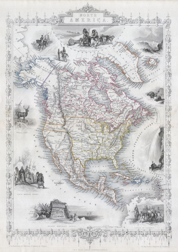
1851 Tallis Map of North America, Retaining Pre-1848 Borders
1851 (undated) $400.00
1850 Tallis Map of North America ( Texas at fullest )
NorthAmerica-tallis-1850$200.00

Title
North America.
1850 9.5 x 14 in (24.13 x 35.56 cm)
1850 9.5 x 14 in (24.13 x 35.56 cm)
Description
This is John Tallis's highly desirable and very rare 1850 Map of the North America. Made shortly following the entry of Texas into the Union, this map depicts an important point in American history. Herein Texas is shown at near its fullest extent including Santa Fe and but excluding the Green Mountain extension in the Northwest. Upper California has yet to become a part of the United States and while Oregon is included, Washington remains a part of British America. The mythical Buenaventure River appears in northern California. Offers several beautiful vignettes depicting 'North American Indians,' a 'White Dear,' Beavers, the 'Falls of Niagara,' a 'Convoy of Diamonds,' an 'Ancient Monument, Mexico,' 'Cossacks,' and the Esquimaux Dog-Sledge. Highly decorative border. Undated, but the form of Texas allows us to positively date this to the early 1850 issue of Tallis's valuable map.
Cartographer
John Tallis and Company (1838 - 1851) published views, maps, and atlases in London from roughly 1838 to 1851. Their principal works, expanding upon the earlier maps of John Cary and Aaron Arrowsmith, include an 1838 collection of London Street Views and the 1849 Illustrated Atlas of the World. The firm’s primary engraver was John Rapkin, whose name and decorative vignettes appear on most Tallis maps. Due to the embellishments typical of Rapkin's work, many regard Tallis maps as the last bastion of English decorative cartography in the 19th century. Although most Tallis maps were originally issued uncolored, it was not uncommon for 19th century libraries to commission colorists to "complete" the atlas. The London Printing and Publishing Company of London and New York bought the rights for many Tallis maps in 1850 and continued issuing his Illustrated Atlas of the World until the mid-1850s. Specific Tallis maps later appeared in innumerable mid to late-19th century publications as illustrations and appendices. More by this mapmaker...
Condition
Fine or perfect condition. Blank on verso.
References
Phillips, 804-70.; Rumsey 0466.065.