This item has been sold, but you can get on the Waitlist to be notified if another example becomes available, or purchase a digital scan.
1788 Schraembl / Pownall Map of North America & the West Indies
NorthAmerica2-schraembl-1788$3,000.00

Title
General Karte von Nord America samt den Westindischen Inseln Verfasst von Herrn Pownall
1788 (dated) 39 x 45.25 in (99.06 x 114.935 cm)
1788 (dated) 39 x 45.25 in (99.06 x 114.935 cm)
Description
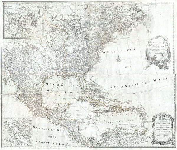
A rare and extraordinary post-colonial wall map of North America by Vienna map publisher Franz Anton Schraembal. Printed in 1788 for inclusion in Schraembal's Allgemeiner Grosser Atlas, this is one of the first maps issued to depict North America following the American Revolutionary War. While this map has been updated to reflect the surveys prepared under Massachusetts governor Thomas Pownall, it is heavily based upon the important 1783 map of North America issued by Sayer and Bennet. The whole is beautifully rendered with wonderful detail regarding the early states, roads, canals, the Great Lakes, American Indian Nations, and explorer's observations. Vermont is not present on the map. Most of the southern states are without western boundaries, but seem to extend only to the Appellation Mountain range. In the upper left quadrant there is an inset of the Baffin and Hudson Bay region including some references to the explorations of Admiral De Fonte in search of a Northwest Passage, as well as to the indigenous Eskimo tribes. Another inset in the lower left quadrant shows the parts of California which Father Franz Kino walked between 1698 and 1701. Kino headed the historic expedition which proved California to be attached to the North American mainland and ultimately defeated the 'California as an Island' theory. Upper right quadrant features an elaborate title cartouche depicting a stylized American Indian woman and cherubs wrestling fish from the sea. A second cartouche in the lower right quadrant features a key to the map. A altogether magnificent map offering both stunning beauty and historic value.
Cartographer
Franz Anton Schrämbl (Schraembl; 1751 - December 13, 1803) was a Vienna-based cartographer working in the later part of the 18th century. Schrämbl was born in Vienna. He became director of the normal school in Troppau but soon quit to set up a bookshop in Vienna. In 1787, with fellow Austrian Franz Johann Joseph von Reilly (1766 - 1820), he founded a publishing firm. He began his great work, the Allgemeiner Grosser Atlas, in the same year. This ambitious large format atlas was to be based upon only the most up-to-date cartographic information available, among them cartographers J. B. B. D'Anville (1697 - 1782) and James Rennel (1742 - 1830), and explorers such as James Cook (1728 - 1779), Charles Roberts (1739 - 1825), and others. The atlas was published in 1800 and became the first Austrian commercial world atlas. The work experienced minimal circulation, possibly due to its high cost. The low sales nearly drove Schrämbl into insolvency, but he recovered through diversification into literature and art books. When Franz Anton died in 1803, his widow Johanna and her brother, the engraver Karl Robert Schindelmayer (1769 - 1839), assumed control of the firm. In 1825, his son, Eduard Schrämbl, took over. More by this mapmaker...
Source
Schraembl, K. A., Allgemeiner Grosser Atlas, (Vienna: Phil. Jos. Schalbacher) 1800.
The Allgemeiner Grosser Atlas, alternatively titled Allgemeiner Grosser Schrämblischer Atlass, is considered the first Austrian commercial Atlas. It is a massive elephant folio atlas published in 1800 by Franz Anton Schrämbl (Schraembl; 1751 - 1803). The atlas drew from the best and most up-to-date cartographic information available, including the works of J. B. B. D'Anville (1697 - 1782) and James Rennel (1742 - 1830), and explorers such as James Cook (1728 - 1779), and Charles Roberts (1739 - 1825), among many others. It was published in Vienna by Phillip Joseph Schalbacher. The atlas was large and expensive, and as such, was of minimal commercial success and had a low circulate - leading to its considerable rarity today. It is believed that the atlas's slow sales and high production costs drove Schrämbl into insolvency by the time of his death in 1803.
Condition
Very good condition. This map has a been professionally cleaned, flattened and backed with linen for stability. Four pieces joined. Minor discoloration on original folds, especially through Mexico in the lower left quadrant. Original hand color. Margnins added all around. Else clean.
References
Phillips, P.L. (Atlases) 694-36, McCorkle, B.B. (New England) 788.6.