1871 Danish Nautical Chart of the North Baltic Sea w/ Stockholm
NorthBalticStockhom-royaldanishchart-1871$1,000.00


Title
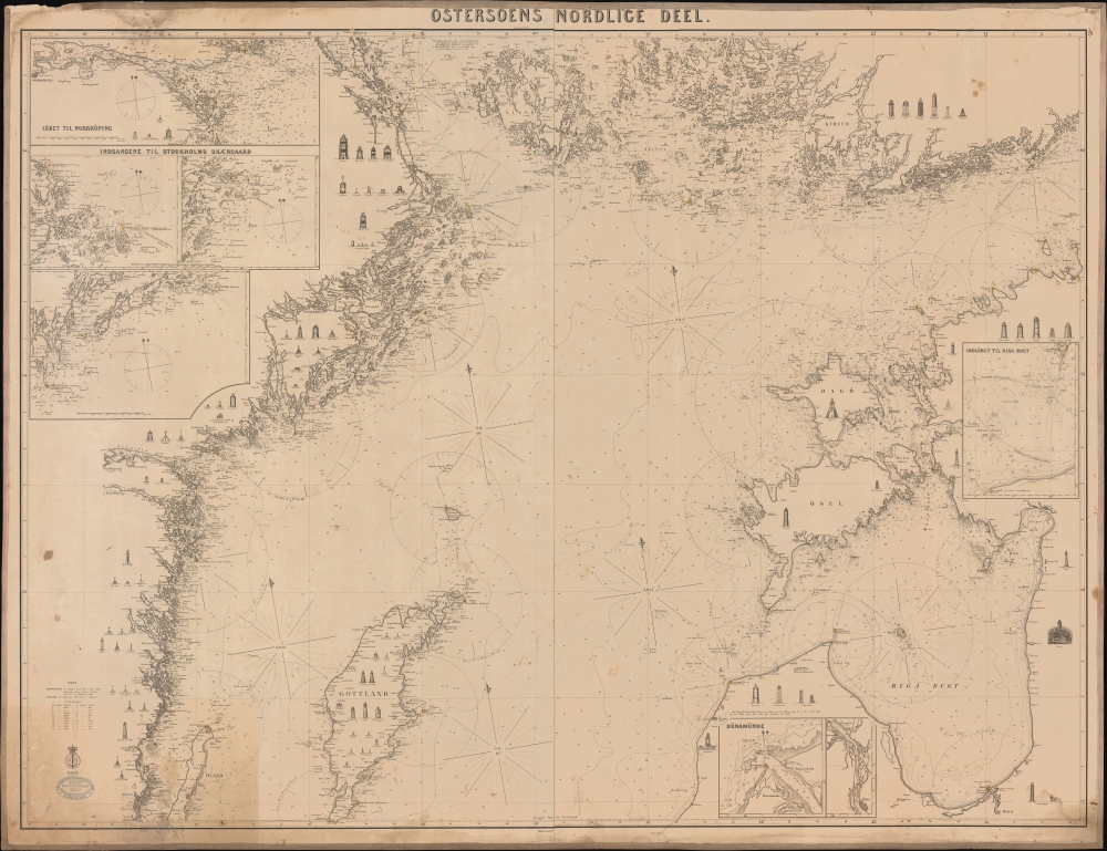
Ostersoens Nordlice Deel.
1871 (dated) 39.5 x 51 in (100.33 x 129.54 cm) 1 : 450000
1871 (dated) 39.5 x 51 in (100.33 x 129.54 cm) 1 : 450000
Description
This is a rare 1871 blueback chart or nautical map of the northern Baltic Sea, including Stockholm, Sweden.
A Closer Look
Coverage embraces from Gotland to the Åland Islands, and from the Swedish coast to Riga, Latvia. Stockholm appears prominently just left of center. This chart is admirable for its profile illustration of the region's many lighthouses. There are inset harbor maps of Norrköping (Sweden), entrances to Stockholm (Sweden), Daugavgrīva (Latvia), Riga (Latvia), and Riga Bay.Blueback Charts
Blueback nautical charts began appearing in London in the late 18th century. Bluebacks, as they came to be called, were privately published large-format nautical charts known for their distinctive blue paper backing. The backing, a commonly available blue manila paper traditionally used by publishers to wrap unbound pamphlets, was adopted as a practical way to reinforce the low-quality paper used by private chart publishers to cut costs. That being said, not all blueback charts are literally backed with blue paper, some are unbacked or backed with linen. Moreover, as blueback charts which were typically composed of multiple sheets, they were designed in a modular fashion, so that multiple charts could be joined to create truly massive custom maps suited for specific voyages. The earliest known blueback charts include a 1760 chart issued by Mount and Page, and a 1787 chart issued by Robert Sayer. The tradition took off in the early 19th century, when British publishers like John Hamilton Moore, Robert Blachford, James Imray, William Heather, John William Norie, Charles Wilson, David Steel, R. H. Laurie, and John Hobbs, among others, rose to dominate the chart trade. Bluebacks became so popular that the convention was embraced by chartmakers outside of England, including Americans Edmund March Blunt and George Eldridge, as well as Scandinavian, French, German, Russian, and Spanish chartmakers. Blueback charts remained popular until the late 19th century, when government-subsidized organizations like the British Admiralty Hydrographic Office and the United States Coast Survey, began issuing their own superior charts on high-quality paper that did not require reinforcement.A Closer Look
The chart was published by the Royal Danish Chart Archive, first in 1869, and again here, with updates to 1871. This map is rare, this being the only example we have identified. The chart is owned jointly by Geographicus and Vetus Carta Maps.Cartographer
The Royal Danish Chart Archive (1784 - 1973) or Det Kongelige Danske Søkaart-Archiv was established by the Danish Crown in 1784. Impressed by the French Dépôt des Cartes de Marine, the crown recruited Captain Lieutenant Poul de Løwenørn to act as the first director of the archive. Løwenørn collected nautical charts from all parts of the world. The archive later began issuing its own charts, often improving and updating older charts. The archive was merged with the Nautical Chart Archive and Life Guard in 1973. More by this mapmaker...
Condition
Very good. Overall toning. Minor marginal staining. Backed on blue paper.