1757 Seutter / Lotter Map of the Northeast with a View of New York City
Northeast-lotter-1757$3,500.00

Title
Recens Edita Totius Novi Belgii, in America Septentrionali siti, delineatio cura et sumtibus Tob. Conr. Lotteri, Sac. Caes. Maj. Geographi August. Vind.
1757 (undated) 19.5 x 22.5 in (49.53 x 57.15 cm) 1 : 2200000
1757 (undated) 19.5 x 22.5 in (49.53 x 57.15 cm) 1 : 2200000
Description
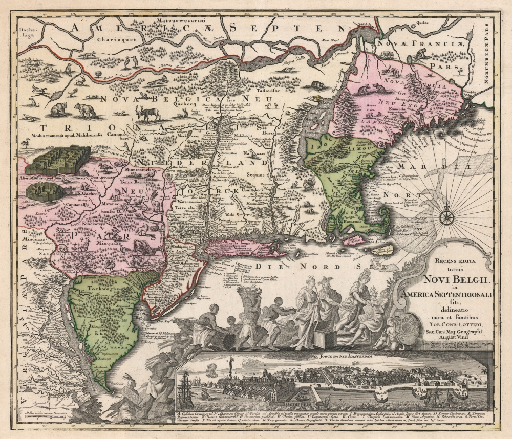
This is Conrad Tobias Lotter's 1757 map of New York, New England, and the mid-Atlantic colonies. It represents the final map in the Jansson-Visscher series. Despite the map's cartography being over a century old, this map continued to capture the idea of this part of the world for Europeans in general and a German audience in particular.
Although Seutter's map preserved the Restitutio View, it did not reprise that map's decorative work, instead presenting a new allegorical cartouche. Here, in the baroque style, King George II is depicted enthroned. Athena (goddess of wisdom in war) presents the King with a laurel and a baton, signs of victory. Hera (queen of the gods) stands over a chest full of coins, while Hermes (patron of communication and commerce) gestures with his caduceus, indicating that the wealth ought to be directed towards the English King. Meanwhile, a crowd of African figures laboriously carries goods to present to the King, a reference to the fact that the British colony was powered by slave labor.
The present example, from a side-bound atlas, has no centerfold and is particularly fine. If you are considering an example of this map for your collection, this is the one you want.
A Closer Look
Coverage extends from the Chesapeake Bay to modern-day Maine, and from the St. Lawrence River to the James River. The map follows on the long legacy of the Jansson-Visscher series, inheriting cartographic conventions dating to 1651. This map significantly updates the series with the naming of Boston. It is the first in the series to do so (albeit misspelled as 'Briston' in this state) but otherwise follows the triumphs and errors of its predecessors.Jansson-Visscher Series
As noted, the present map represents the final iteration of the Jansson-Visscher Series. The series originated with the 1651 Jansson Belgii Novi, Angliae Novae, Et Partis Virginiae Novissima Delineatio. This so-called 'prototype' map was the first iteration of the dominant mapping of New England and the Mid-Atlantic well into the eighteenth century. It was the first to approximate Manhattan and Long Island. It was also the first map to show Swedish settlements along the Delaware and the first reasonably well-informed compendium of regional Native American settlements.The Restitutio View
The view of New York decorating the lower right-hand corner of the map is not the so-called 'Visscher View' that embellished the earlier maps of this type. Instead, this view is from the 1674 second state of the Allard map, termed the 'Restitutio View' for its celebration of the re-occupation of New Amsterdam by the Dutch in 1673. This view is notable not only for its ironies (the Dutch would return the port to the English in exchange for their recognition of Dutch claims to Surinam a scant year later) but for its early depiction of the palisade that would give Wall Street its name. The letter key below the view also marks the city's shoreline defenses, the location of the collect pond and its (then) fresh water, the Dutch Reformed Church, and the Stuyvesant mansion.Although Seutter's map preserved the Restitutio View, it did not reprise that map's decorative work, instead presenting a new allegorical cartouche. Here, in the baroque style, King George II is depicted enthroned. Athena (goddess of wisdom in war) presents the King with a laurel and a baton, signs of victory. Hera (queen of the gods) stands over a chest full of coins, while Hermes (patron of communication and commerce) gestures with his caduceus, indicating that the wealth ought to be directed towards the English King. Meanwhile, a crowd of African figures laboriously carries goods to present to the King, a reference to the fact that the British colony was powered by slave labor.
Publication History and Census
This map was engraved by Matthias Seutter in 1730. When Lotter inherited a share of the firm after Seutter's death in 1757, he amended the cartouche with his own imprint and continued to include the map in his own atlases. This is an example of the fourth state, according to Tooley, with Lotter's imprint and the inclusion of the misspelled 'Briston.' We see twenty examples of this map cataloged in OCLC in a variety of states.The present example, from a side-bound atlas, has no centerfold and is particularly fine. If you are considering an example of this map for your collection, this is the one you want.
CartographerS
Tobias Conrad Lotter (1717 - 1777) was a German engraver and map publisher. Lotter was the son of a baker and city guardsman, but married Euphrosina (1709 - 1784) Seutter, elder daughter of the prominent map publisher Matthäus Seutter. He began working at his is father-in-law's map business about 1740. Between 1740 and 1744 he produced, under Seutter's imprint, the Atlas minor, Praecipua orbis terrarum imperia, regna et provincias, Germania potissimum tabelli. Upon Seutter's death, in 1757, the firm's stock was taken over by his son, Albrecht Karl Seutter (1722 - 1762), who himself died in 1762, just a few years later. The remaining Seutter map plates were subsequently divided between Lotter and the publisher Johan Mitchell Probst (1727 - 1776). With the support of his sons, Matthäus Albrecht (1741 - 1810), Georg Friedrich (1744 - 1801) and Gustav Conrad (1746-1776), Tobias Conrad Lotter succeeded in building on the economic success and professional reputation of his father-in-law. In time, Lotter became one of the most prominent mid-18th century map publishers working in the German school. After Lotter's death in 1777, the business was taken over by his two eldest sons, who, lacking their father's business acumen, presided over the firm's slow decline. It was nonetheless passed on to a subsequent generation of Lotters, Matthäus Albrecht Lotter's sons, Gabriel (1776 - 1857) and Georg Friedrich (1787 - 1864), who pushed it into further decline until it faded out in the early-19th century. More by this mapmaker...
Matthäus Seutter (1678 - 1757) was one of the most important and prolific German map publishers of the 18th century. Seutter was born the son of a goldsmith but apprenticed as a brewer. Apparently uninspired by the beer business, Seutter abandoned his apprenticeship and moved to Nuremberg where he apprenticed as an engraver under the tutelage of the prominent J. B. Homann. Sometime in the early 1700s Seutter left Homann to return to Augsburg, where he worked for the prominent art publisher Jeremiad Wolff (1663 - 1724), for whom he engraved maps and other prints. Sometime around 1717 he established his own independent cartographic publishing firm in Augsburg. Though he struggled in the early years of his independence, Seutter's engraving skill and commitment to diversified map production eventually attracted a substantial following. Most of Seutter's maps are heavily based upon, if not copies of, earlier work done by the Homann and De L'Isle firms. Nonetheless, by 1731/32 Seutter was one of the most prolific publishers of his time and was honored by the German Emperor Karl VI who gave him the title of Imperial Geographer, after which most subsequent maps included the Avec Privilege designation. Seutter continued to publish until his death, at the height of his career, in 1757. Seutter had two engraver sons, Georg Matthäus Seutter (1710 - 173?) and Albrecht Carl Seutter (1722 - 1762). Georg Matthäus quit the business and relocated to Woehrdt in 1729 (and probably died shortly thereafter), leaving the family inheritance to his wastrel brother Albrecht Carl Seutter, who did little to advance the firm until in own death in 1762. Following Albrecht's death, the firm was divided between the established Johann Michael Probst (1727 - 1776) firm and the emerging firm of Tobias Conrad Lotter. Lotter, Matthäus Seutter's son-in-law, was a master engraver and worked tirelessly on behalf of the Suetter firm. It is Lotter, who would eventually become one of the most prominent cartographers of his day, and his descendants, who are generally regarded as the true successors to Matthäus Seutter. (Ritter, M. Seutter, Probst and Lotter: An Eighteenth-Century Map Publishing House in Germany., "Imago Mundi", Vol. 53, (2001), pp. 130-135.) Learn More...
Claes Jansz Visscher (1587 - 1652) established the Visscher family publishing firm, which were prominent Dutch map publishers for nearly a century. The Visscher cartographic story beings with Claes Jansz Visscher who established the firm in Amsterdam near the offices of Pieter van den Keer and Jadocus Hondius. Many hypothesize that Visscher may have been one of Hondius's pupils and, under examination, this seems logical. The first Visscher maps appear around 1620 and include numerous individual maps as well as an atlas compiled of maps by various cartographers including Visscher himself. Upon the death of Claes, the firm fell into the hands of his son Nicholas Visscher I (1618 - 1679), who in 1677 received a privilege to publish from the States of Holland and West Friesland. The firm would in turn be passed on to his son, Nicholas Visscher II (1649 - 1702). Visscher II applied for his own privilege, receiving it in 1682. Most of the maps bearing the Visscher imprint were produced by these two men. Many Visscher maps also bear the imprint Piscator (a Latinized version of Visscher) and often feature the image of an elderly fisherman - an allusion to the family name. Upon the death of Nicholas Visscher II, the business was carried on by the widowed Elizabeth Verseyl Visscher (16?? - 1726). After her death, the firm and all of its plates was liquidated to Peter Schenk. Learn More...
Hugo Allard (1627-1684) was a Dutch draughtsman, engraver and painter, who worked in Tournai and Amsterdam. His son Carel, (1648-1709) carried on the same trade. Most of his own maps were sold as separate publications, or were collected in composite atlases; consequently they tend to be works of great rarity. Learn More...
Jan Jansson or Johannes Janssonius (1588 - 1664) was born in Arnhem, Holland. He was the son of a printer and bookseller and in 1612 married into the cartographically prominent Hondius family. Following his marriage he moved to Amsterdam where he worked as a book publisher. It was not until 1616 that Jansson produced his first maps, most of which were heavily influenced by Blaeu. In the mid 1630s Jansson partnered with his brother-in-law, Henricus Hondius, to produce his important work, the eleven volume Atlas Major. About this time, Jansson's name also begins to appear on Hondius reissues of notable Mercator/Hondius atlases. Jansson's last major work was his issue of the 1646 full edition of Jansson's English Country Maps. Following Jansson's death in 1664 the company was taken over by Jansson's brother-in-law Johannes Waesberger. Waesberger adopted the name of Jansonius and published a new Atlas Contractus in two volumes with Jansson's other son-in-law Elizée Weyerstraet with the imprint 'Joannis Janssonii haeredes' in 1666. These maps also refer to the firm of Janssonius-Waesbergius. The name of Moses Pitt, an English map publisher, was added to the Janssonius-Waesbergius imprint for maps printed in England for use in Pitt's English Atlas. Learn More...
Source
Lotter, C. T., Atlas Geographique, (Augsburg: Lotter), c. 1757.
Condition
Excellent. Margins reinforced; else fine with original wash color.
References
Rumsey 12040.108 (c. 1755 Seutter third state). Tooley, R. V. The Mapping of America p. 292, #27, fourth state. cf. Augustyn / Cohen, Manhattan in Maps, pp. 46-7.