This item has been sold, but you can get on the Waitlist to be notified if another example becomes available, or purchase a digital scan.
1696 Visscher Map of the American East Coast from the Carolinas to Labrador
NortheastCanada-visscher-1696$3,250.00

Title
Nova Tabula Geographica Complectens Borealiorem Americae Partem: in qua Exacte Delineatae Sunt Canada sive Nova Francia, Nova Scotia, Nova Anglia, Novum Belgium, Pensylvania, Virginia, Carolina et Terra Nova, cum Omnibus Littorum. Pulvinorumque Profunditatibus. Amstelodami. à Nicolao Visscher. Cum Privilegio Ordinum Generalium Foederati Belgii./ Carte Nouvelle contenant la Partie d'Amerique la Plus Septentrionale, ou Sont Exactement Dècrites les Provinces Suivantes comme le Canada ou Nouvelle France, La Nouvelle Ecosse, la Nouvelle Angleterre, les Nouveaux Païs Bas, la Pensylvanie, la Virginie, la Caroline et l'Ile de Terre Neuve avec les profondeuis le Long des Côtes et sur les Bancs. Par Nicolas Visscher avec Privilege des Etats Géneraux.
1696 (undated) 23.5 x 19 in (59.69 x 48.26 cm) 1 : 4000000
1696 (undated) 23.5 x 19 in (59.69 x 48.26 cm) 1 : 4000000
Description
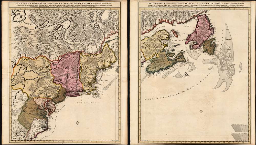
This is Nicolas Visscher II's 1696 two-sheet map of the North American eastern seaboard and the Canadian Maritimes, in a beautiful example of its earliest acquirable state with rich original color. It represents the 17th century's most finely-detailed mapping of the coast from the Carolinas to Labrador. Also, it is the first Dutch map of the region to diverge from the 'Jansson-Visscher' precursor maps.
A Closer Look
The two sheets focus on the North American colonies of France and Great Britain - not least among them the former Dutch colony of New Netherlands (New York), which retains its Dutch name along with its new English appellation of 'New Jork.' In further acknowledgement of the increase of English influence, details in Long Island and New England (such as Eastham Cut in Cape Cod) show evidence of consultation with English charts of the period. The map is rich with indigenous tribal names in the largely unexplored interior, while the coastline is populated with European place names. The coastal regions are, more precise and recognizable than earlier Dutch works although the interior is still largely imaginary. Lakes Champlain and George still appear north of the Connecticut River, far to the east of their proper location north of the Hudson. Lakes Ontario, Huron and Erie are distorted. The mythical Appalachian Lake (a holdover from the Le Moyne map of 1691) still appears upriver from Craven County in the Carolinas.A Magnificent Engraving
In comparison with earlier Dutch maps of the Northeast and Canada, this work reveals the steady advance in the arts of engraving and printing. Presses were getting larger, as is evidenced by the larger-format copperplates employed. Moreover, the engraving itself is finer than maps produced earlier in the century, allowing for sharper detail and smaller, more legible text. The pictorially rendered wooded areas and mountains, the sharply-hachured coastlines, and the finely-stippled shallows proclaim the skill of the engraver (Luggert van Anse). This work also represents a stylistic shift from its precursors. The animals and depictions of Native Americans that fill the interior spaces on earlier Dutch works are here absent. In lieu of speculative lakes and river systems, the sea is left clear and open, with no ships or monsters. Each sheet graced with a single elegant and understated compass rose.Publication History and Census
This map was engraved by Luggert van Anse in and around 1696 for inclusion in the younger Visscher's Atlas Minor. Burden has identified two examples of a first, 'proof state' of the map lacking mountains or trees. The present example exhibits these elements but lacks the Schenk imprint appearing in 1717, and thus we identify it as a c. 1696 second state, the earliest acquirable to the collector. The map, both as a pair and in its separate sheets, is reasonably well represented in institutional collections.CartographerS
Claes Jansz Visscher (1587 - 1652) established the Visscher family publishing firm, which were prominent Dutch map publishers for nearly a century. The Visscher cartographic story beings with Claes Jansz Visscher who established the firm in Amsterdam near the offices of Pieter van den Keer and Jadocus Hondius. Many hypothesize that Visscher may have been one of Hondius's pupils and, under examination, this seems logical. The first Visscher maps appear around 1620 and include numerous individual maps as well as an atlas compiled of maps by various cartographers including Visscher himself. Upon the death of Claes, the firm fell into the hands of his son Nicholas Visscher I (1618 - 1679), who in 1677 received a privilege to publish from the States of Holland and West Friesland. The firm would in turn be passed on to his son, Nicholas Visscher II (1649 - 1702). Visscher II applied for his own privilege, receiving it in 1682. Most of the maps bearing the Visscher imprint were produced by these two men. Many Visscher maps also bear the imprint Piscator (a Latinized version of Visscher) and often feature the image of an elderly fisherman - an allusion to the family name. Upon the death of Nicholas Visscher II, the business was carried on by the widowed Elizabeth Verseyl Visscher (16?? - 1726). After her death, the firm and all of its plates was liquidated to Peter Schenk. More by this mapmaker...
Luggert van Anse (fl. 1677-1716) was a Dutch map engraver, who worked in the shops of Visscher, van Keulen, and Pieter Husson. He appears to have been prolific, but as is often the case with Dutch engravers employed by larger printers or publishers, he would have been considered more of a workman than an artist, and consequently his education and early life are poorly documented. Learn More...
Source
Visscher II, Nicolas, Atlas minor sive geographia compendiosa, (Amsterdam) 1696.
Condition
Very good. Both sheets trimmed close on top and bottom, but margins complete. Left sheet reinforced at areas of oxidation. Faint foxing in water area of right sheet. Else excellent with a bold, sharp strike and superb, rich original color. Approximate size is given for each sheet.
References
OCLC 1240365988. Burden, P., The Mapping of North America, #731 state 2. McCorkle, B. B, New England in Early Printed Maps 1513 - 1800, #689.8. Kershaw, Kenneth A., Early Printed Maps of Canada, #319.