1840 Blunt Nautical Chart or Map of New England and Nova Scotia
NorthEasternNorthAmerica-blunt-1840$2,000.00


Title
The north eastern coast of North America from New York to Cape Canso, including Sable Island.
1840 (dated) 38.5 x 76.5 in (97.79 x 194.31 cm) 1 : 680000
1840 (dated) 38.5 x 76.5 in (97.79 x 194.31 cm) 1 : 680000
Description
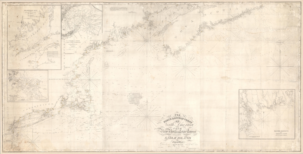
This is Edmund Blunt's rare, monumental 1840 nautical chart or map of the northeast United States, extending from New York to Cape Canso in Nova Scotia, and is the most authoritative American chart of these waters available at the time. It provides not only granular detail of the coastline, but also detailed soundings for the crucial sailing lanes from Halifax to Boston. It is a working chart - typically referred to as a 'blueback chart' due to the color of the reinforcing paper it was originally mounted to. Rather than contend with multiple charts, mariners typically preferred large charts composed of several sheets: hence the impressive expanse of the present chart.
The Main Chart
This chart covers from Barnigat Lighthouse on the Jersey Shore to the Cranberry Island Lighthouse east of Cape Canso and extends farther east to include Sable Island and the Sable Island bank. As such, the chart is an essential tool for navigators making the transatlantic crossing from England and Ireland via Halifax.The Insets
The chart includes minutely-detailed insets of essential harbors, including Halifax Harbor, Cape Cod Harbor, Buzzards Bay, and Boston Harbor. Three of these - all but Cape Cod - rely on the still authoritative (though rapidly aging) charts of the great nautical cartographer J. F. W. DesBarres. The Cape Cod chart, exhaustively sounded, is early work of the topographical engineer James Duncan Graham.Blueback Charts
Blueback nautical charts began appearing in London in the late 18th century. Bluebacks, as they came to be called, were privately published large format nautical charts known for their distinctive blue paper backing. The backing, a commonly available blue manila paper traditionally used by publishers to wrap unbound pamphlets, was adopted as a practical way to reinforce the low-quality paper used by private chart publishers trying to cut costs. The earliest known blueback charts include a 1760 chart issued by Mount and Page and a 1787 chart issued by Robert Sayer. The tradition took off in the early 19th century, when British publishers like John Hamilton Moore, Robert Blachford, James Imray, William Heather, John William Norie, Charles Wilson, David Steel, R. H. Laurie, and John Hobbs, among others, rose to dominate the chart trade. Bluebacks became so popular that the convention was embraced by chartmakers outside of England, including Americans Edmund March Blunt and George Eldridge, as well as Scandinavian, French, German, Russian, and Spanish chartmakers. Blueback charts remained popular until the late 19th century, when government subsidized organizations, such as the British Admiralty Hydrographic Office and the United States Coast Survey, began issuing their own superior charts on high quality paper that did not require reinforcement.Publication History and Census
This scarce chart was executed in 1828, when Blunt's workshops were located at 154 Water Street on the corner of Maiden Lane. This example, with the notation that it has been corrected to 1840, shows the firm's new address of 179 Water Street, at the Southeast corner of Burling Slip. 1848 examples of this chart, for example the copy at the New York Public Library, show this address but with significantly altered typography in the title, suggesting more drastic changes to the chart beyond the title. We see five examples of the 1828 edition in OCLC, with two further copies of the 1844 edition and two of the 1848. We see no examples of the present 1840 edition in any institutional collections.CartographerS
Edmund March Blunt (June 20, 1770 - 1862) was an American navigator, bookseller, chartmaker, and cartographer based in Newburyport, Massachusetts. Blunt was born in Portsmouth, New Hampshire in 1770. In 1796, along with the nominal assistance of prominent navigator Captain Lawrence Furlong, Blunt published The American Coast Pilot, one of the most important published works on American navigation. Although much of the work was plagiarized from British publications, the Coast Pilot was an immediate popular success. In response to the popularity of his work, Blunt published 21 subsequent editions, each with important updates and revisions. The first edition to contain map plates was printed in 1804. Following a fire that destroyed his offices at The Sign of the Bible in 1811, Blunt moved his business to New York and opened a new shop, The Sign of the Quadrant. His sons Edmund Jr. (1799 - 1866) and George William (1802 - 1878), joined the firm in 1824 and eventually took over the family business, renaming the firm 'E. and G. W. Blunt'. They both produced their own nautical books, charts, and instruments, as well as republished their father’s work. In 1830, Edmund accepted a position under Ferdinand Hassler at the United States Office of the Coast Survey. Much of Blunt's original work eventually found its way into U.S. Coast Survey Publications. George closed the firm in 1872 and sold the plates and chart copyrights to the U.S. Coast Survey and the U.S. Navy Hydrographic Office. Due to the quality and detail of Blunt's work, revised editions of his most important charts were republished well into the 1880s. More by this mapmaker...
Joseph Frederick Wallet Des Barres (November 22, 1721 - October 24. 1824) was born in Switzerland in 1721. He is known to have attended the University of Basel where he tutored under the great mathematician Daniel Bernoulli. Following his studies in Basel, Des Barres immigrated to Great Britain where he continued his education at the Royal Military College of Woolwich. Sometime in the 1850s Des Barres joined the American Regiment of the Royal Army in the capacity of Military Engineer. He was assigned to the team surveying the St. Lawrence River where he worked with the legendary cartographer Samuel Holland as well as the young James Cook. Afterwards Des Barres went on to survey and map the Maritime Provinces of New Brunswick, Nova Scotia, and Newfoundland. Des Barres work is known for its stunning combination of accuracy and aesthetic appeal. Augustyn, in Manhattan in Maps writes that with Des Barres, "nautical charting took an unprecedented leap toward greater precision and graphic sophistication". Upon his return to England in 1774, Des Barres was assigned to compile all of the most current cartographic information on the New World into the seminal Atlantic Neptune, which has been described as the "most splendid collection of charts, plates and views ever published" (National Maritime Museum Catalogue). Des Barres would eventually return to Canada where he lived another forty years as a wealthy land owner and active political figure. He died at the ripe old age of 103, one of the few centenarians of the early 19th century. Learn More...
James Duncan Graham (April 4, 1799 - December 28, 1865) was an American topographical engineer active with the Army Corps of Engineers in the first half of the 19th century. Graham was born in Prince William County, Virginia to a family of Scottish descent. He studied at West Point and entered the army upon graduating in 1817 as a Third Lieutenant of the Corps of Artillery. He is reported to have embodied the 'highest accomplishments of the polished gentleman and distinguished scholar.' During his long career with the Topographical Engineers, Graham participated in many of the most important events of the 19th century, ranging from the Mexican American War (1846 - 1848) and the Civil War (1861 - 1865), to surveying the Texas Boundary, producing the first scientifically accurate survey of Cape Cod, mapping the Great Lakes, and the survey of the Mason Dixon Line. Graham died in his home in Boston of sudden heart failure at 66 years of age. Learn More...
Condition
Average. Mended tears with some loss, areas of scuffing. Stabilized and mounted on fresh linen.
References
Compare with Rumsey 4662.004. OCLC 229468079.