This item has been sold, but you can get on the Waitlist to be notified if another example becomes available, or purchase a digital scan.
1700 Pierre Mortier Nautical Map of the Arctic and a Northwest Passage
NorthwestPassage-mortier-1700$500.00

Title
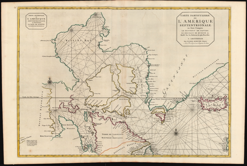
Carte Particuliere de L'Amerique Septentrionale ou sont Compris Le Destroit de Davids, le Destroit de Hudson, etc. Dresse sur les Relations les plus Nouvelles.
1700 (undated) 23 x 32.5 in (58.42 x 82.55 cm) 1 : 8000000
1700 (undated) 23 x 32.5 in (58.42 x 82.55 cm) 1 : 8000000
Description
This is a superb, original-color first-state example of Pierre Mortier's 1700 chart of the North Atlantic and Arctic Canada. The map is significant for embodying European hopes for the Northwest Passage.
A Closer Look
This grand, two-sheet engraving spans from the western coast of Ireland in the east to beyond Buttons Bay and Hudson Bay, thus including the southern coastline of Greenland, all of Iceland, the Labrador Coast, and the northwestern extreme of Newfoundland. Named bodies of water include Davis Strait, Baffins Bay, the Hudson Strait, Hudson Bay, and Buttons Bay. At an indeterminate distance to the chart's extreme west appears the Strait of Anian - the speculative passage thought to exist between North America and Asia. As indicated by the presence of two separate cartouches, the two sheets could also be had as separate works; however, in Mortier's mammoth Neptune François, they were bound joined, as here.The Northwest Passage
The 17th-century explorations of these water did not chart the western coasts of Baffins and Buttons Bays sufficiently for chartmakers to be certain whether or not their various inlets and bays concealed water passages leading further west. Since explorers and mapmakers alike were in eager search for such a passage, the westernmost coastlines of this chart have been left with an array of hopeful gaps - particularly those areas to the west of New North and New South Wales. The inclusion on the lower left of the Destroit d'Anian explicitly plays on the hope that there might be a passage to the Pacific via one or another of those tantalizing channels. A note in French explains, 'Somewhere around here is the Strait of Anian between New Mexico and the Land of Ieso (Hokkaido), through which it is believed that there is communication between the Atlantic and the Pacific Oceans.'Publication History and Census
This map was engraved by Pierre Mortier in 1700 for inclusion in hisNeptune François. The map is well-represented institutionally and appears occasionally on the market.Cartographer
Pierre Mortier (January 26, 1661 - February 18, 1711) or Pieter Mortier was a cartographer, engraver, and print seller active in Amsterdam during the later 17th and early 18th centuries. Mortier, then known as Pieter, was born in Leiden. He relocated to Paris from 1681 to 1685, adopting the French name Pierre, which he retained throughout his career. While in France, he developed deep French connections by bringing sophisticated Dutch printing technology and experience to nascent French map publishers such as Guillaume De L'Isle (1675 - 1726), Alexis-Hubert Jaillot (c. 1632 - 1712), and Nicholas de Fer (1646 - 1720). Consequently, much of Mortier's business was built upon issuing embellished high quality editions of contemporary French maps - generally with the permissions of their original authors. In the greater context of global cartography, this was a significant advantage as most Dutch map publishes had, at this point, fallen into the miasma of reprinting their own outdated works. By contrast, the cartographers of France were producing the most accurate and up to date charts anywhere. Mortier's cartographic work culminated in the magnificent nautical atlas, Le Neptune Francois. He was awarded the Privilege, an early form of copyright, in 1690. Upon Pierre's death in 1711 this business was inherited by his widow. In 1721, his son Cornelius Mortier took over the day to day operation of the firm. Cornelius partnered with his brother-in-law Jean Covens to form one of history's great cartographic partnerships - Covens and Mortier - which continued to publish maps and atlases until about 1866. More by this mapmaker...
Source
Mortier, P., Suite de Neptune François, ou atlas nouveau des cartes marines, (Amsterdam: P. Mortier) 1700.
Condition
Excellent. Full margins and original outline color. Few unobtrusive spots, else fine.
References
OCLC 745062011. Rumsey 12178.000. Burden, P. The Mapping of North America vol 2, #763.