This item has been sold, but you can get on the Waitlist to be notified if another example becomes available, or purchase a digital scan.
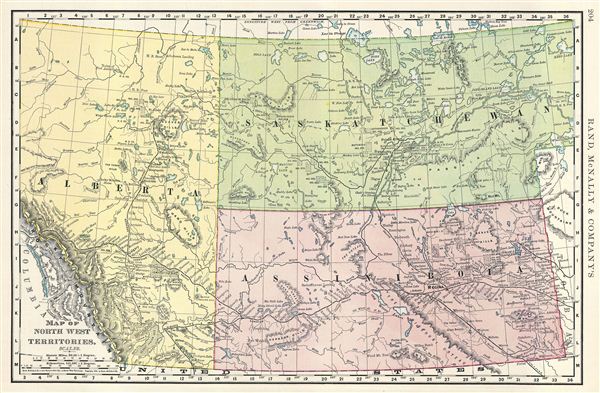
1891 Rand McNally Map of the Northwest Territories of Canada
NorthWestTerritories-randmcnally-1895$50.00

Title
Map of North West Territories.
1891 (dated) 20 x 13 in (50.8 x 33.02 cm) 1 : 2400000
1891 (dated) 20 x 13 in (50.8 x 33.02 cm) 1 : 2400000
Description
This is a beautiful example of Rand McNally and Company's 1893 map of the Northwest Territories of Canada. It covers Alberta, Saskatchewan and Assiniboia (a historic district). Several Indian Reservation sites are noted. The modern territory, created in 1870, resulted from the transfer of the North-Western Territory held by the British Empire to the government of Canada. Color coded according to provinces and regions, the map notes several towns, cities, rivers, mountains, railroads and various other topographical details with relief shown by hachure. This map was issued as plate no. 364 in the 1895 issue of Rand McNally and Company's Indexed Atlas of the World - possibly the finest atlas Rand McNally ever issued.
Cartographer
Rand, McNally and Co. (fl. 1856 - present) is an American publisher of maps, atlases and globes. The company was founded in 1856 when William H. Rand, a native of Quincy, Massachusetts, opened a print shop in Chicago. Rand hired the recent Irish immigrant Andrew McNally to assist in the shop giving him a wage of 9 USD per week. The duo landed several important contracts, including the Tribune's (later renamed the Chicago Tribune) printing operation. In 1872, Rand McNally produced its first map, a railroad guide, using a new cost effective printing technique known as wax process engraving. As Chicago developed as a railway hub, the Rand firm, now incorporated as Rand McNally, began producing a wide array of railroad maps and guides. Over time, the firm expanded into atlases, globes, educational material, and general literature. By embracing the wax engraving process, Rand McNally was able to dominate the map and atlas market, pushing more traditional American lithographic publishers like Colton, Johnson, and Mitchell out of business. Eventually Rand McNally opened an annex office in New York City headed by Caleb S. Hammond, whose name is today synonymous with maps and atlases, and who later started his own map company, C. S. Hammond & Co. Both firms remain in business. More by this mapmaker...
Source
Rand McNally & Co., Foreign Countries. Rand, McNally & Co's Indexed Atlas of the World (Complete in Two Volumes)…, (Chicago) 1895.
Condition
Very good. Text on verso.
References
Rumsey 3565.057 (1897 edition). Philip (atlases) 1026 (1898 edition).