This item has been sold, but you can get on the Waitlist to be notified if another example becomes available, or purchase a digital scan.
1900 Garnier Pocket Map or Plan of Paris, France
NouveauParisMonumental2-garnier-1900$147.50

Title
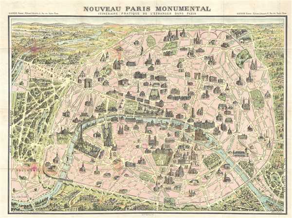
Nouveau Paris Monumental. Itinéraire Pratique de l'Étranger dand Paris.
1900 (undated) 20 x 27 in (50.8 x 68.58 cm) 1 : 16000
1900 (undated) 20 x 27 in (50.8 x 68.58 cm) 1 : 16000
Description
This is an extremely attractive 1900 tourist pocket map of Paris, France. Published by Garnier Freres, this is most likely the 1900 first edition. The map depicts the walled city of Paris and the immediate vicinity from Billancourt to Aubervilliers and from Puteau to Charenton. Important buildings are illustrated in profile, including the Eiffel Tower, the Arc de Triomphe, Sacre-Coeur, the Louvre, Nortre Dame, and others. This map was issued in various editions, from roughly 1900 to 1937. Though most examples are undated we can assign an approximate date due to the development of the Metro system and the map's overall style and construction. In this case the first Paris Metro line, the Chemin de Fer Metropolitain, from Maillot to Vincennes, appears, but the extension from Étoile to Trocadéro is not present, allowing this map to be dated between September 1, 1900 and October 2, 1900, when that extension opened.
This map was published by Garnier Freres as part of one of their tourist guides.
This map was published by Garnier Freres as part of one of their tourist guides.
Cartographer
Garnier Frères (1833 - June, 1983) was a prominent publishing house and bookstore based in Paris, France. The publishing firm was founded in 1833 by the brothers Auguste (1812 - 1887) and Hippolyte Garnier (1815 or 1816 – 1859, photo at right). Their younger brother Pierre-Auguste (1807 – 1899) also joined the firm. Yet another brother, Baptiste-Louis Garnier (1822 - 1893) joined in 1844. The popular Paris bookshop, located in the arcades of the Palais-Royal in the gallery Peristyle Montpensier, followed shortly after in 1838. They opened another location in 1853 in the former government hotel, at the corner of rue de Lille and rue des Saints-Pères. The firm prospered through the publication of low cost editions French classics. Their corpus of work includes maps, guides, novels, historical works, and essays. In June of 1983 the firm filed for bankruptcy and their assents were taken over by Presses de la Cité, a subsidiary of InfoMédia, which was itself liquidated in 2000. More by this mapmaker...
Condition
Very good. Verso reinforcement along left side. Soiling along left original fold line. Slight wear along original fold lines. Blank on verso.