This item has been sold, but you can get on the Waitlist to be notified if another example becomes available, or purchase a digital scan.
1749 Vaugondy Map of the English Colonies: New England, New York, Virginia
NouvelleAngleterre-vaugondy-1749$100.00

Title
Nouvelle Angleterre, Nouvelle York, Nouvelle Jersey. Pensilvanie Mariland et Virginie. Par le Sr. Robert de Vaugondy Fils de Mr. Robert Geog. ordin. du Roi
1749 (dated) 8 x 7 in (20.32 x 17.78 cm) 1 : 5800000
1749 (dated) 8 x 7 in (20.32 x 17.78 cm) 1 : 5800000
Description
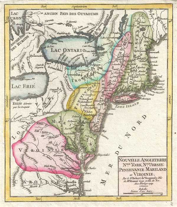
This is a hand colored 1749 Didier Robert de Vaugondy map of the English Colonies in North America, including New England and the Mid-Atlantic colonies, on the cusp of the French and Indian War (1754 – 1763). The organization of the map is significant, with the French controlled Great Lakes dominating the map. The English colonies, which are disproportionally reduced, hug the coast but, save through their alliance with the Iroquois federation, have no access to the Great Lakes. Similarly, Pennsylvania, Virginia and Maryland are limited to lands east of the Appalachian Mountains, reflecting the French claims that would soon lead to war.
The map depicts from Lake Erie and Lake Huron on the left to the Atlantic Ocean on the right and from Lake Huron and New Scotland at the top to North Carolina and Albemarle (Albermale) Bay at the bottom. The map depicts the colonies of New England (Nouvelle Angleterre), New York (Nouvelle Yorck), Pennsylvania (Pennsylvanie), Maryland (Mariland), Virginia (Virginie), and Carolina (Caroline). Louisiana is labeled, which at this point in history was French territory. The Iroquois nation is also depicted.
Numerous American cities are labeled, including Boston, New York (New Yorck), Philadelphia (Philadelphie), and Jamestown. Long Island is labeled, as well as Chesapeake Bay (Baye de Chesapeack). Lake Champlain and Lake Ontario are depicted as well as several rivers.
This map was published by Gilles Robert de Vaugondy in his Atlas Universel, Portatif et Militaire in the 1749 edition.
Cartographer
Robert de Vaugondy (fl. c. 1716 - 1786) was French may publishing from run by brothers Gilles (1688 - 1766) and Didier (c. 1723 - 1786) Robert de Vaugondy. They were map publishers, engravers, and cartographers active in Paris during the mid-18th century. The father and son team were the inheritors to the important Nicolas Sanson (1600 - 1667) cartographic firm whose stock supplied much of their initial material. Graduating from Sanson's maps, Gilles, and more particularly Didier, began to produce their own substantial corpus. The Vaugondys were well-respected for the detail and accuracy of their maps, for which they capitalized on the resources of 18th-century Paris to compile the most accurate and fantasy-free maps possible. The Vaugondys compiled each map based on their own geographic knowledge, scholarly research, journals of contemporary explorers and missionaries, and direct astronomical observation. Moreover, unlike many cartographers of this period, they took pains to reference their sources. Nevertheless, even in 18th-century Paris, geographical knowledge was limited - especially regarding those unexplored portions of the world, including the poles, the Pacific Northwest of America, and the interiors of Africa, Australia, and South America. In these areas, the Vaugondys, like their rivals De L'Isle and Buache, must be considered speculative or positivist geographers. Speculative geography was a genre of mapmaking that evolved in Europe, particularly Paris, in the middle to late 18th century. Cartographers in this genre would fill in unknown lands with theories based on their knowledge of cartography, personal geographical theories, and often dubious primary source material gathered by explorers. This approach, which attempted to use the known to validate the unknown, naturally engendered rivalries. Vaugondy's feuds with other cartographers, most specifically Phillipe Buache, resulted in numerous conflicting papers presented before the Academie des Sciences, of which both were members. The era of speculative cartography effectively ended with the late 18th-century explorations of Captain Cook, Jean Francois de Galaup de La Perouse, and George Vancouver. After Didier died, his maps were acquired by Jean-Baptiste Fortin, who in 1787 sold them to Charles-François Delamarche (1740 - 1817). While Delamarche prospered from the Vaugondy maps, he defrauded Vaugondy's window Marie Louise Rosalie Dangy of her rightful inheritance and may even have killed her. More by this mapmaker...
Source
Robert de Vaugondy, G., Atlas Portatif, Universel, et Militaire, (Paris: Vaugondy, Durand, Pissot) 1749.
Condition
Very good. Blank on verso. Original press mark visible.
References
Pedley, M. S., Bel et Utile, p. 213, 468.