1705 De Fer Map of Mexico, Florida, and the Gulf Coast
NouvelleEspagneFloride-defer-1702-2$1,000.00

Title
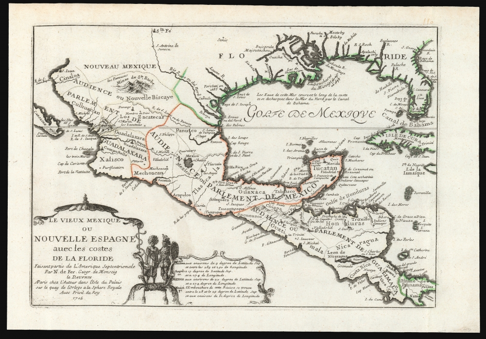
Le Vieux Mexique ou Nouvelle Espagne avec les costes de la Floride.
1702 (dated) 9 x 13 in (22.86 x 33.02 cm) 1 : 10000000
1702 (dated) 9 x 13 in (22.86 x 33.02 cm) 1 : 10000000
Description
This is Nicolas De Fer's 1705 map of Mexico, the Gulf Coast, and Florida. It illustrates French ambitions in the New World, particularly hopes to size and control the rich Mines of Santa Barbara. This map, and others like it, were subsequently influential in the inflation of the Mississippi Company - one of the world's first bubble economies.
When Rene Robert Cavelier, Sieur de La Salle (1643 - 1687), set out from France, his intention was to found his colony at the mouth of the Mississippi River. Although it may have been an error that La Salle founded his colony far to the west of the Mississippi at Matagorda Bay, he was certainly aware of the political implication of its perceived proximity to the Santa Barbara Mines. In addition to several eastward expeditions in search of the mouth of the Mississippi, there is strong evidence that La Salle also traveled extensively west of the Mississippi, no doubt in hopes of seizing the Santa Barbara mines. Louis Hennepin, a Franciscan Recollect priest, both a high-ranking member of La Salle's expedition and a potent rival to La Salle, claimed that La Salle intended to seize glory in the form of the Santa Barbara mines before he set out on his first expedition. Such was not an impractical ambition. When La Salle sailed from France to found his colony, France and Spain were involved in the War of the Reunions (1683 - 1684). Seizing the Santa Barbara Mines would have been a major blow to the Spanish and a territorial and financial coup for the French. Little did he know, the war with Spain ended just two weeks after he sailed from France, and the nations became cautious allies.
Curiously, despite Santa Barbara being a prominent and wealthy silver city and one of the northernmost outposts of New Mexico back in France, La Salle's failure to conquer it gave the mines an 'El Dorado-like' mystique. John Law, the Scottish economist, millionaire, con artist, and murderer wasted no time capitalizing on the Santa Barbara legend to promote his nascent Mississippi Company. Law disseminated rumors that the 'Mines of St. Barbe' had been discovered and distributed ingots supposedly taken from the mine. Speculation on the mines, as well as other scams, pushed Mississippi Company stock to astronomical highs, creating one of the world's first bubble economies. This was possible because of cartographers like De Fer, who, by illustrating the mines on their maps, made the legend of the Mines de Ste. Barbe part of early 18th-century French popular mythology.
A Closer Look
Centered on the Gulf of Mexico, coverage embraces from Baja California to Florida and Cuba, covering the Gulf of Mexico, parts of New Mexico as far north as Santa Fe and as far as south in Central America as Panama. De Fer intended this map to illustrate the full extent of Spanish domination in North America and French dominance of the coastline between Florida and Texas. French settlements are identified at Fort Biloxi and Fort Maurepas, which are noted but not specifically named. Well within the regions color-coded as part of Spain, Fort Saint Louis, La Salle's failed colony, is also noted.The Mines of St. Barbe or the Santa Barbara silver mines of Chihuahua-Durango
Perhaps this map's most striking feature is its dramatic illustration of 'Les Fameuses Mines de Ste. Barbe'. Although called by some the El Dorado of New Spain, these mines are real and were well-known in the 17th century. The Mines of St. Barbe are better known as the Santa Barbara silver mines of Chihuahua-Durango. They were first discovered in 1567 by the Spanish Conquistador Rodrigo del Rio de Losa (1536 - 1604). Although initially difficult to exploit due to extreme remoteness and lack of indigenous labor, by 1600, Santa Barbara had grown to a population of 7000 and was becoming a wealthy silver town.When Rene Robert Cavelier, Sieur de La Salle (1643 - 1687), set out from France, his intention was to found his colony at the mouth of the Mississippi River. Although it may have been an error that La Salle founded his colony far to the west of the Mississippi at Matagorda Bay, he was certainly aware of the political implication of its perceived proximity to the Santa Barbara Mines. In addition to several eastward expeditions in search of the mouth of the Mississippi, there is strong evidence that La Salle also traveled extensively west of the Mississippi, no doubt in hopes of seizing the Santa Barbara mines. Louis Hennepin, a Franciscan Recollect priest, both a high-ranking member of La Salle's expedition and a potent rival to La Salle, claimed that La Salle intended to seize glory in the form of the Santa Barbara mines before he set out on his first expedition. Such was not an impractical ambition. When La Salle sailed from France to found his colony, France and Spain were involved in the War of the Reunions (1683 - 1684). Seizing the Santa Barbara Mines would have been a major blow to the Spanish and a territorial and financial coup for the French. Little did he know, the war with Spain ended just two weeks after he sailed from France, and the nations became cautious allies.
Curiously, despite Santa Barbara being a prominent and wealthy silver city and one of the northernmost outposts of New Mexico back in France, La Salle's failure to conquer it gave the mines an 'El Dorado-like' mystique. John Law, the Scottish economist, millionaire, con artist, and murderer wasted no time capitalizing on the Santa Barbara legend to promote his nascent Mississippi Company. Law disseminated rumors that the 'Mines of St. Barbe' had been discovered and distributed ingots supposedly taken from the mine. Speculation on the mines, as well as other scams, pushed Mississippi Company stock to astronomical highs, creating one of the world's first bubble economies. This was possible because of cartographers like De Fer, who, by illustrating the mines on their maps, made the legend of the Mines de Ste. Barbe part of early 18th-century French popular mythology.
Publication History and Census
This map was published only in De Fer's Suite de l'Atlas Curieux, a supplement to his better known Atlas Curieux. A dozen examples of the 1702 issue are listed in OCLC, but only one example of this 1705 state.Cartographer
Nicholas de Fer (1646 - October 25, 1720) was a French cartographer and publisher, the son of cartographer Antoine de Fer. He apprenticed with the Paris engraver Louis Spirinx, producing his first map, of the Canal du Midi, at 23. When his father died in June of 1673 he took over the family engraving business and established himself on Quai de L'Horloge, Paris, as an engraver, cartographer, and map publisher. De Fer was a prolific cartographer with over 600 maps and atlases to his credit. De Fer's work, though replete with geographical errors, earned a large following because of its considerable decorative appeal. In the late 17th century, De Fer's fame culminated in his appointment as Geographe de le Dauphin, a position that offered him unprecedented access to the most up to date cartographic information. This was a partner position to another simultaneously held by the more scientific geographer Guillaume De L'Isle, Premier Geograph de Roi. Despite very different cartographic approaches, De L'Isle and De Fer seem to have stepped carefully around one another and were rarely publicly at odds. Upon his death of old age in 1720, Nicolas was succeeded by two of his sons-in-law, who also happened to be brothers, Guillaume Danet (who had married his daughter Marguerite-Geneviève De Fer), and Jacques-François Bénard (Besnard) Danet (husband of Marie-Anne De Fer), and their heirs, who continued to publish under the De Fer imprint until about 1760. It is of note that part of the De Fer legacy also passed to the engraver Remi Rircher, who married De Fer's third daughter, but Richer had little interest in the business and sold his share to the Danet brothers in 1721. More by this mapmaker...
Source
De Fer, N. Suite de l'Atlas curieux, par M. de Fer (Paris) 1705-1716
Condition
Very good. Original color, refreshed. Marginal mend not impacting image, else excellent.
References
OCLC 13828136. Pastoureau, Mireille, Les Atlas Francais, XVIe-XVIIe Siecles Repertoire bibliographique et etude, M. De Fer I-A, 111. Lowery, W., The Lowery Collection, 254.