1744 Bellin Map or Plan of New Orleans, Louisiana
NouvelleOrleans-bellin-1744-9$900.00

Title
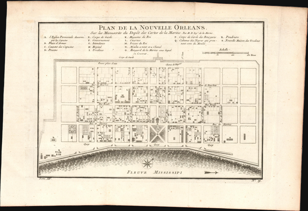
Plan de la Nouvelle Orleans. Sur les Manuscrits du Depôt des Cartes de la Marine.
1744 (undated) 7.5 x 11 in (19.05 x 27.94 cm) 1 : 4800
1744 (undated) 7.5 x 11 in (19.05 x 27.94 cm) 1 : 4800
Description
This scarce 1744 map by J. N. Bellin is the earliest obtainable map of New Orleans, Louisiana. It was issued for Pierre François Xavier de Charlevoix's Histoire et Description Generale de la Nouvelle France, one of the earliest published accounts of the city.
The company rapidly attracted investment, and its shares rocketed in value, generating so much wealth that the Law devised a secondary scheme to assume the national debt of the French state, which had grown to untenable levels by the many wars in the preceding decades. When colonists encountered a hostile environment rife with tropical diseases, which killed many, the scheme collapsed, along with the value of the company, wiping away fortunes in days and leaving the French state in dire fiscal straits. Along with a nasty hurricane in 1722, these were hardly auspicious beginnings for New Orleans, but through centuries of environmental engineering and public health measures, a thriving city nonetheless emerged, especially once trade along the Mississippi River started booming in the 19th century.
Charlevoix's history proved exceptionally influential as one of the most comprehensive works on North America predating the French and Indian War. Copies of the Histoire et Description Generale were found in the libraries of many 18th-century luminaries, including Voltaire, Franklin, and Jefferson. Jefferson especially admired Charlevoix's work, calling it 'a particularly useful species of reading' and no doubt influenced his decision to pursue the historic 1803 Louisiana Purchase, possibly the most significant event in the post-colonial history of North America.
A Closer Look
Oriented to the northwest, Bellin's map covers the original settlement of New Orleans along the Mississippi River and inland as far the Fosse plein d'eau (roughly translated: 'Pit full of Water') near modern-day Dauphine Street, and from modern-day Iberville Street (shown but not named) to Barracks Street (shown but not named). The map illustrates about 100 buildings, with 18 specifically identified via an alphabetically coded table set just above the map. The layout of today's French Quarter is immediately recognizable, with Jackson Square (Place d'Armes) bordered by a Catholic Church (St. Louis Cathedral) on the waterfront. Most of the street names here remain in use today.Early History of New Orleans
New Orleans was founded in 1718 by the French at a strategic site considered amenable to developing a thriving colonial outpost. The Regent of France, Philip II, Duke of Orléans, for whom the city is named, entrusted his Controller General of Finances of France, a Scottish economist named John Law, with promoting the colony, which resulted in one of the earliest bubbles in financial history. The Mississippi Company was modeled on the chartered monopolies common among European powers at the time. Law proved to be an excellent evangelist, touting the Eden-like qualities and tremendous opportunities for wealth in Louisiana (by which he meant the entire Mississippi watershed), despite having never set foot there.The company rapidly attracted investment, and its shares rocketed in value, generating so much wealth that the Law devised a secondary scheme to assume the national debt of the French state, which had grown to untenable levels by the many wars in the preceding decades. When colonists encountered a hostile environment rife with tropical diseases, which killed many, the scheme collapsed, along with the value of the company, wiping away fortunes in days and leaving the French state in dire fiscal straits. Along with a nasty hurricane in 1722, these were hardly auspicious beginnings for New Orleans, but through centuries of environmental engineering and public health measures, a thriving city nonetheless emerged, especially once trade along the Mississippi River started booming in the 19th century.
Publication History and Census
This plan was first engraved by D'Heulland for inclusion by Bellin in Pierre François Xavier de Charlevoix's 1744 Histoire et description generale de la Nouvelle France. We are aware of two subsequent, re-engraved plates; a 1764 and 1757 (reused in 1780). There may be different states of these three plates that have not been enumerated. These subsequent editions were issued to accompany Prévost's Histoire des Voyages and reissues of Charlevoix.Charlevoix's history proved exceptionally influential as one of the most comprehensive works on North America predating the French and Indian War. Copies of the Histoire et Description Generale were found in the libraries of many 18th-century luminaries, including Voltaire, Franklin, and Jefferson. Jefferson especially admired Charlevoix's work, calling it 'a particularly useful species of reading' and no doubt influenced his decision to pursue the historic 1803 Louisiana Purchase, possibly the most significant event in the post-colonial history of North America.
Cartographer
Jacques-Nicolas Bellin (1703 - March 21, 1772) was one of the most important cartographers of the 18th century. With a career spanning some 50 years, Bellin is best understood as geographe de cabinet and transitional mapmaker spanning the gap between 18th and early-19th century cartographic styles. His long career as Hydrographer and Ingénieur Hydrographe at the French Dépôt des cartes et plans de la Marine resulted in hundreds of high quality nautical charts of practically everywhere in the world. A true child of the Enlightenment Era, Bellin's work focuses on function and accuracy tending in the process to be less decorative than the earlier 17th and 18th century cartographic work. Unlike many of his contemporaries, Bellin was always careful to cite his references and his scholarly corpus consists of over 1400 articles on geography prepared for Diderot's Encyclopedie. Bellin, despite his extraordinary success, may not have enjoyed his work, which is described as "long, unpleasant, and hard." In addition to numerous maps and charts published during his lifetime, many of Bellin's maps were updated (or not) and published posthumously. He was succeeded as Ingénieur Hydrographe by his student, also a prolific and influential cartographer, Rigobert Bonne. More by this mapmaker...
Condition
Very good. Original fold lines visible; else excellent.
References
Lemmon, A., Magill, J., and Wiese, J., Charting Louisiana: Five Hundred Years of Maps, #171. Brown University, John Carter Brown Library, E744 C479h5.