This item has been sold, but you can get on the Waitlist to be notified if another example becomes available, or purchase a digital scan.
1716 Homann Map of New York and New England
NovaAnglia-homann-1716$1,500.00

Title
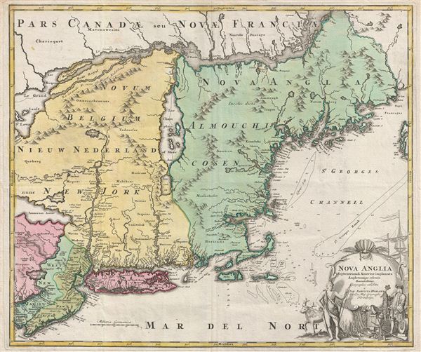
Nova Anglia Septentrionali Americae Implantata Anglorumque Coloniis Florentissima Geographice Exhibita a Joh. Baptista Homann.
1716 (undated) 19.5 x 23.5 in (49.53 x 59.69 cm)
1716 (undated) 19.5 x 23.5 in (49.53 x 59.69 cm)
Description
A significant though often overlooked piece, this is J. B. Homann's c. 1716 map of New England, New York, and New Jersey. Though titled 'Nova Anglia,' (New England) Homann's map actually covers a much broader area from New France (Canada) to the Delaware Bay, and from Philadelphia to Nova Scotia, inclusive of all of New England, New York, and New Jersey, as well as parts of adjacent Canada and Pennsylvania. The map identifies both European and American Indian settlements, differentiating between the two by rendering indigenous settlements as pictorial villages, huts and all, and European towns as small circles, major cities like Philadelphia and Boston being the exception.
The Cartouche
The beautifully engraved decorative cartouche in the lower right quadrant depicts an elegantly-dressed European merchant trading manufactured goods with a Native American in return for beaver pelts. This might well be a microcosmic view of the entire political and economic status of this region in the early 18th century. European settlement was sparse, largely confined to coastlines and a few inland entrepôts like Albany, shown here at the northern terminus of the Hudson River. The fur trade was the dominant force driving both settlement and trade throughout 17th and 18th century New England. Although Homann identifies some areas as Nieuw Nederland and Novum Belgium, referencing the 17th century Dutch attempts to colonize the Hudson Valley, the more aggressive English colonists had long since attained regional dominance. This is perhaps also suggestive of Homann's Dutch sources, most likely Visscher's 1689 map, Nova Tabula Geographica Complectens Borealiorem Americae Partem.The Interior
Most Europeans were content to follow the example of the gentleman in our cartouche by letting the more skilled American Indians trap beavers and other fur-bearing animals, then acquiring them through trade along the coastline at various inland depots. As the cartouche work suggests, guns and metal tools were the primary currency despite being specifically forbidden by the crown - for obvious reasons. Consequently, little was known of the interior aside from vague offered up by secretive Indians and a few early probes mostly associated with river systems. The Hudson River had not been explored beyond Albany. Although, the French explorer Samuel de Champlain had mapped Lake Champlain in 1609, challenges in determining Longitude caused him to place the lake well east of its actual location. Fur traders had also heard of the lake from the American Indians with whom they did business. To them, it was the ultimate source, a sort of Beaver Shangri La, however, they knew it by another name, Lake Iroquois - after the tribal confederation that dominated the area. Here Lake Champlain is properly labeled and, Lake Iroquois, just to the south, is now doubt Lake George.Codfish
Homann also incorporates numerous depth soundings along the entire cost line and notes various shoals and banks, particularly around Nantucket and Cape Cod, which is rendered as an island. His incorporation of this data is no doubt associated with New England's other major industry - the Cod fishery. The banks off Cape Cod were exceptionally rich in Cod, which, when salted and dried, provided sustainable tack for most nautical voyages will into the 19th century.Cartographic Curiosities
Additional elements of interest abound. Homann places a large lake, the Zuyd Lac, on the Delaware River. This is simply a misinterpretation of the natural widening of the Delaware at the Delaware Water Gap. In Pennsylvania, a vast swampland is an exaggeration of natural wetlands in modern day Bucks County, today known as the Quakertown Swamp, a protected area popular with birders. Sennecaas Lacus, just west of the Hudson, is most likely a mismapping of Lake Erie.Norumbega - the New Englan El Dorado
The fictitious region of Norumbeag is placed in present-day Maine at the head of Penebrock Bay, another reference to the explorations of Samuel de Champlain who associated the Penobscot with the 'Great River of Norumbega.' Norumbega, as it is more commonly spelled, was believed to be a riverside settlement of fair skinned people, possibly the descendants of Vikings, first described by Jean Allefonsce in 1542,The river is more than 40 leagues wide at its entrance and retains its width some thirty or forty leagues. It is full of Islands, which stretch some ten or twelve leagues into the sea. ... Fifteen leagues within this river there is a town called Norombega, with clever inhabitants, who trade in furs of all sorts; the town folk are dressed in furs, wearing sable. ... The people use many words which sound like Latin. They worship the sun. They are tall and handsome in form. The land of Norombega lies high and is well situated.Norombega appeared on maps from as early as the late 1500s.
Publication History and Census
The first appearance of this map was in Homann's c. 1716 Atlas Novus. It was subsequently reissued for several decades with only slight changes. The present example reflects the second state, with Manhattan in clear insular form, labeled as 'N. Loch.'Cartographer
Johann Baptist Homann (March 20, 1664 - July 1, 1724) was the most prominent and prolific map publisher of the 18th century. Homann was born in Oberkammlach, a small town near Kammlach, Bavaria, Germany. As a young man, Homann studied in a Jesuit school and nursed ambitions of becoming a Dominican priest. Nonetheless, he converted to Protestantism in 1687, when he was 23. It is not clear where he mastered engraving, but we believe it may have been in Amsterdam. Homann's earliest work we have identified is about 1689, and already exhibits a high degree of mastery. Around 1691, Homann moved to Nuremberg and registered as a notary. By this time, he was already making maps, and very good ones at that. He produced a map of the environs of Nürnberg in 1691/92, which suggests he was already a master engraver. Around 1693, Homann briefly relocated to Vienna, where he lived and studied printing and copper plate engraving until 1695. Until 1702, he worked in Nuremberg in the map trade under Jacob von Sandrart (1630 - 1708) and then David Funck (1642 - 1709). Afterward, he returned to Nuremberg, where, in 1702, he founded the commercial publishing firm that would bear his name. In the next five years, Homann produced hundreds of maps and developed a distinctive style characterized by heavy, detailed engraving, elaborate allegorical cartouche work, and vivid hand color. Due to the lower cost of printing in Germany, the Homann firm could undercut the dominant French and Dutch publishing houses while matching their diversity and quality. Despite copious output, Homann did not release his first major atlas until the 33-map Neuer Atlas of 1707, followed by a 60-map edition of 1710. By 1715, Homann's rising star caught the attention of the Holy Roman Emperor Charles VI, who appointed him Imperial Cartographer. In the same year, he was also appointed a member of the Royal Academy of Sciences in Berlin. Homann's prestigious title came with several significant advantages, including access to the most up-to-date cartographic information as well as the 'Privilege'. The Privilege was a type of early copyright offered to very few by the Holy Roman Emperor. Though less sophisticated than modern copyright legislation, the Privilege offered limited protection for several years. Most all J. B. Homann maps printed between 1715 and 1730 bear the inscription 'Cum Priviligio' or some variation. Following Homann's death in 1724, the firm's map plates and management passed to his son, Johann Christoph Homann (1703 - 1730). J. C. Homann, perhaps realizing that he would not long survive his father, stipulated in his will that the company would be inherited by his two head managers, Johann Georg Ebersberger (1695 - 1760) and Johann Michael Franz (1700 - 1761), and that it would publish only under the name 'Homann Heirs'. This designation, in various forms (Homannsche Heirs, Heritiers de Homann, Lat Homannianos Herod, Homannschen Erben, etc.) appears on maps from about 1731 onwards. The firm continued to publish maps in ever-diminishing quantities until the death of its last owner, Christoph Franz Fembo (1781 - 1848). More by this mapmaker...
Source
Homann, J. B., Neuer Atlas bestehend in einig curieusen Astronomischen Kuppren und vielen auserlesenen accuratensten Land-Charten über die Gantze Welt, (Nuremberg: Homann), 1716.
Homann's Neuer Atlas bestehend in einig curieusen Astronomischen Kuppren und vielen auserlesenen accuratensten Land-Charten über die Gantze Welt was first publihsed in 1707 with 33 maps. A second edition followed in 1710 with 60 maps. Subsequent editions followed until about 1730. The title page notes proudly that the atlas features measurements based on the 'Copernican principle of the moving sky', a truly state-of-the-art innovation for the period. Regardless of editions, collations of the atlas are inconsistent, with some examples having less, while others have more maps - a consequence of the fact that the map sheets were delivered loose, to be bound at the buyer's discretion, and so some buyers chose to omit maps they did not consider relevant, or add others they did. Between editions, the constituent maps, particularly of European regions, were regularly updated to reflect the most recent political events. The atlas continued to be published by Homann's son, J. C. Homann (1703 - 1730), and then by Homann Heirs. Most examples also feature a fine allegorical frontispiece with the title Atlas Novus Terrarum Orbis Imperia, regna et Status, which was used for multiple Homann atlases, including the Neuer Atlas and the Atlas Minor.
Condition
Very good condition. Original centerfold. The finest example of this map we have ever encountered.
References
Goss, J., The Mapping of North America: Three Centuries of Map-Making 1500-1860 #50. McCorkle, B.B., New England in Printed Maps 1513-1800: An Illustrated Carto-Bibliography, 724.1. Portinaro, P., and Knirsch, F., The Cartography of North America 1500-1800, pl.116. Van Ermen, E., The United States in Old Maps and Prints, p.47. Sellers, J. and Van Ee, P. M., Maps and Charts of North America and the West Indies 1750-1789, 807. Manasek, F. J., Collecting Old Maps, 73. Baynton-Williams, Checklist: Printed Maps of New England to 1780, Part IV: 1700-1780, #1716.01b.