This item has been sold, but you can get on the Waitlist to be notified if another example becomes available, or purchase a digital scan.
1635 Blaeu Map of Italy
NovaItaliae-blaeu-1635$800.00

Title
Nova Italiæ Delineatio.
1635 (undated) 15.5 x 20.5 in (39.37 x 52.07 cm) 1 : 3700000
1635 (undated) 15.5 x 20.5 in (39.37 x 52.07 cm) 1 : 3700000
Description
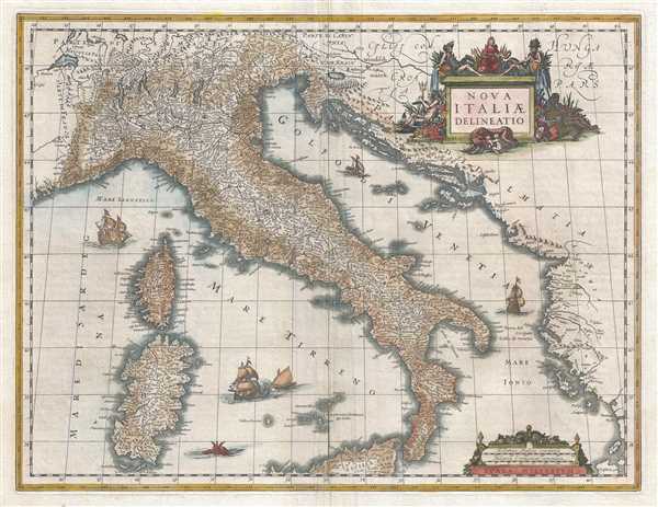
This is a 1635 first edition Willem Janszoon Blaeu map of Italy. The map depicts the region from western France to the Balkans and from Switzerland (labeled here as Parte di Germania) to northern Sicily. Highly detailed, myriad cities, towns, and villages are labeled throughout Italy and in the surrounding area, including Rome (Roma), Florence (Fiorenza), Pisa, Milan, (Milano), Venice (Venetia), Cannes (Canes), France, and Geneva (Geneve), Switzerland. Numerous towns, islands, and other locations are also labeled along the Dalmatian coast, modern day Croatia, Bosnia and Herzegovina, and Montenegro. Though not clearly delineated, this map predates Italian unification by nearly two hundred years, so a collection of duchies, kingdoms, and other states are labeled within Italy. Innumerable rivers and lakes are illustrated throughout, along with the Alps along Italy's northern border. Both Sardinia and Corsica are depicted in detail, with towns, villages, coastal locations, and rivers all illustrated and labeled. Five sailing ships of different sizes are illustrated in the Tyrrhenian Sea and the Adriatic Sea, along with a sea monster near Sicily. A decorative title cartouche, complete with an illustration of Romulus and Remus and the wolf that adopted them, is situated in the upper right corner.
Blaeu issued two atlas maps of Italy, the present first edition from 1635, and a subsequent revised edition. This map was created by Willem Janszoon Blaeu and published in 1635.
The Crypto-Island of 'M. Sardo'
As authoritative as Magini's 1608 wall map Italia Nuova was, one of its hallmarks - and those maps based on it - was the placement of a mysterious mountainous island 'M. Sardo' in the Gulf of Taranto. Despite being reproduced faithfully on near every 17th century map of the peninsula, the origins of this imaginary island have long been obscure. More recently, the scholar/collector Vladimirio Valerio discovered a interesting notation on the Otranto map in the 1595 Stigliola manuscript Atlas of the Kingdom of Naples (added to his collection in 1975). On that manuscript, a crude mountain-hump is mapped in the Gulf of Taranto - the first known instance in print or otherwise of any such 'M. Sardo' in those waters. While no such island or mountain actually exists, there is, near the tip of Otranto, a mountaintop village - Monte Sardo - notable for its visibility both from the Gulf of Otranto and the Gulf of Venice. Thus the manuscript 'M. Sardo' is a crude coastal profile highlighting a observable coastal navigational feature. Valerio's theorizes that, in compiling his masterpiece map of Italy, Magini consulted the Stigliola as the best and most detailed map of southern Italy. In doing so, he misinterpreted the navigational notation, preserving it as a literal mountain in the middle of the Gulf, and retaining the name M. Sardo. Magini's work was so authoritative that Blaeu copied the map, errors and all; and in turn, with few exceptions, the rest of the European mapmaking community followed.
Cartographer
Willem Janszoon Blaeu (1571 - October 18, 1638), also known as Guillaume Blaeu and Guiljelmus Janssonius Caesius, was a Dutch cartographer, globemaker, and astronomer active in Amsterdam during the late 16th and early 17th centuries. Blaeu was born 'Willem Janszoon' in Alkmaar, North Holland to a prosperous herring packing and trading family of Dutch Reformist faith. As a young man, he was sent to Amsterdam to apprentice in the family business, but he found the herring trade dull and instead worked for his cousin 'Hooft' as a carpenter and clerk. In 1595, he traveled to the small Swedish island of Hven to study astronomy under the Danish Enlightenment polymath Tycho Brahe. For six months he studied astronomy, cartography, instrument making, globe making, and geodesy. He returned to Alkmaar in 1596 to marry and for the birth of his first son, Johannes (Joan) Blaeu (1596 – 1673). Shortly thereafter, in 1598 or 1599, he relocated his family to Amsterdam where he founded the a firm as globe and instrument makers. Many of his earliest imprints, from roughly form 1599 - 1633, bear the imprint 'Guiljelmus Janssonius Caesius' or simply 'G: Jansonius'. In 1613, Johannes Janssonius, also a mapmaker, married Elizabeth Hondius, the daughter of Willem's primary competitor Jodocus Hondius the Elder, and moved to the same neighborhood. This led to considerable confusion and may have spurred Willam Janszoon to adopt the 'Blaeu' patronym. All maps after 1633 bear the Guiljelmus Blaeu imprint. Around this time, he also began issuing separate issue nautical charts and wall maps – which as we see from Vermeer's paintings were popular with Dutch merchants as decorative items – and invented the Dutch Printing Press. As a non-Calvinist Blaeu was a persona non grata to the ruling elite and so he partnered with Hessel Gerritsz to develop his business. In 1619, Blaeu arranged for Gerritsz to be appointed official cartographer to the VOC, an extremely lucrative position that that, in the slightly more liberal environment of the 1630s, he managed to see passed to his eldest son, Johannes. In 1633, he was also appointed official cartographer of the Dutch Republic. Blaeu's most significant work is his 1635 publication of the Theatrum orbis terrarum, sive, Atlas Novus, one of the greatest atlases of all time. He died three years later, in 1638, passing the Blaeu firm on to his two sons, Cornelius (1616 - 1648) and Johannes Blaeu (September 23, 1596 - December 21, 1673). Under his sons, the firm continued to prosper until the 1672 Great Fire of Amsterdam destroyed their offices and most of their printing plates. Willem's most enduring legacy was most likely the VOC contract, which ultimately passed to Johannes' son, Johannes II, who held the position until 1617. As a hobbyist astronomer, Blaeu discovered the star now known as P. Cygni. More by this mapmaker...
Source
Blaeu, W., Atlas Major, (Amsterdam: Blaeu) 1635.
In 1662 Joan Blaeu published his masterwork, which has been described as 'the greatest and finest atlas ever published' (Verwey, 1952): his monumental, eleven-volume Atlas Maior. This contained nearly six hundred maps, more than two hundred in excess of the Blaeus' mainstay the Atlas Novus. The former work already being renowned for the quality and beauty of its maps, Blaeu not only added copious material but improved the sophistication of his work: many of the newly-added maps utilized larger-sized presses and sheets, and the artistry applied to the engravings was often far superior to that of the earlier maps in the atlas - many of which by now were 30, and some more than 50 years old. Blaeu's Atlas Maior was published from 1662 to 1672, consisting of some 594 maps compiled into upwards of 9 volumes with some editions containing as many as 12 volumes. This triumphant work's publishing life was cut violently short when, in 1672, the Blaeu's mammoth workshop was destroyed by fire; surviving stock would be sold at auction between 1674 and 1677, occasionally appearing under the imprint of later Dutch printers such as Pieter Schenk and Pieter Mortier. The maps added to the Atlas Maior, owing to their tragically short publishing life, are among the hardest-to-find of the Blaeu maps.
Condition
Very good. Even overall toning. Closed margin tears professionally repaired on verso. Text on verso.
References
OCLC 776391868.