1749 Bellin Map of Nova Zembla and the Kara Sea
NovaZemla-Bellin-1749$175.00

Title
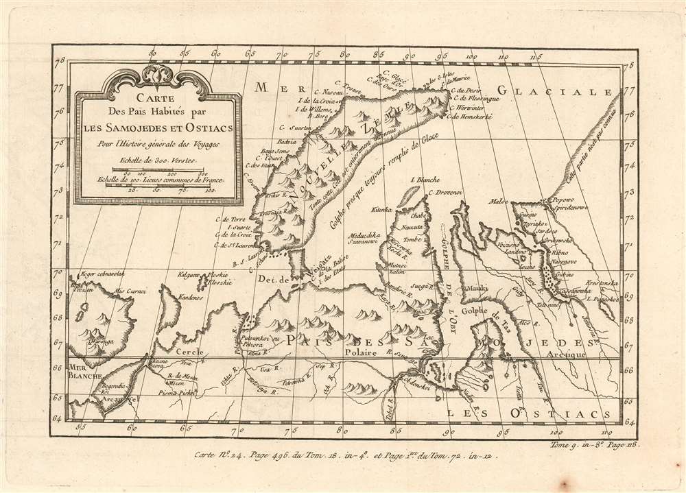
Carte Des Pais Habités par Les Samojedes et Ostiacs Pour l'Histoire Générale des Voyages.
1749 (undated) 6.75 x 9.5 in (17.145 x 24.13 cm) 1 : 9800000
1749 (undated) 6.75 x 9.5 in (17.145 x 24.13 cm) 1 : 9800000
Description
This is a 1749 Bellin map of the northwestern coast of Russia, focusing on the island of Nova Zembla, the mouth of the River Ob, and the limits of European efforts to achieve a northeast passage. The eastern shore of Nova Zembla is sketched in and noted to be entirely unknown; The Kara sea is not named, but it is described as a gulf 'nearly always full of ice.' The Ob and the Yenisea rivers are shown with reasonable accuracy, but beyond the mouth of the unnamed Pyasina River, the coastline is conjectural and, again, n'est pas connue.
Despite its appearance in Prévost's Histoire générale des voyages - a work perhaps better known for its imaginative flourish than for its factuality - Bellin drew on state-of-the-art knowledge for the maps he contributed. Though the map was intended to contextualize Prévost's discussion of Russias indigenous tributaries to the Tsars, Bellin's map presents a reasonably accurate depiction of what Europeans understood of the geography of this remote region.
Despite its appearance in Prévost's Histoire générale des voyages - a work perhaps better known for its imaginative flourish than for its factuality - Bellin drew on state-of-the-art knowledge for the maps he contributed. Though the map was intended to contextualize Prévost's discussion of Russias indigenous tributaries to the Tsars, Bellin's map presents a reasonably accurate depiction of what Europeans understood of the geography of this remote region.
Publication History and Census
This map appears to be rare on the market, with no price records since 1985. OCLC lists six copies of the separate map in various editions. Prévost's Histoire is well represented in institutional collections.CartographerS
Jacques-Nicolas Bellin (1703 - March 21, 1772) was one of the most important cartographers of the 18th century. With a career spanning some 50 years, Bellin is best understood as geographe de cabinet and transitional mapmaker spanning the gap between 18th and early-19th century cartographic styles. His long career as Hydrographer and Ingénieur Hydrographe at the French Dépôt des cartes et plans de la Marine resulted in hundreds of high quality nautical charts of practically everywhere in the world. A true child of the Enlightenment Era, Bellin's work focuses on function and accuracy tending in the process to be less decorative than the earlier 17th and 18th century cartographic work. Unlike many of his contemporaries, Bellin was always careful to cite his references and his scholarly corpus consists of over 1400 articles on geography prepared for Diderot's Encyclopedie. Bellin, despite his extraordinary success, may not have enjoyed his work, which is described as "long, unpleasant, and hard." In addition to numerous maps and charts published during his lifetime, many of Bellin's maps were updated (or not) and published posthumously. He was succeeded as Ingénieur Hydrographe by his student, also a prolific and influential cartographer, Rigobert Bonne. More by this mapmaker...
Antoine François Prévost d'Exiles (April 1, 1697 – November 25, 1763), usually known the Abbé Prévost, was a French author and novelist. Having had difficulty in his youth determining a preference for life in the military or life among the Jesuits, he eventually wound up with the Benedictines, with whom he took vows. Despite his taking the vows, the vows evidently did not take with him: in 1728 he abandoned his abbey and fled to London. Naturally, he became a writer. In this he was prolific, both producing his own work and translations of others. Beginning in 1726, he published the first volume of his Histoire générale des voyages, which he worked on for the remained of his life and which was completed by his associates after his death, stretching to 25 volumes. Learn More...
Source
Prévost, A., Histoire Générale des Voyages, ou Nouvelle Collection de Toutes les Relations de Voyages par Mer et par Terre..., (Paris: Didot) 1746 - 1759, Supplements 1761 - 1801.
Prévost's Histoire Générale des Voyages is a 15-volume compendium of travel literature initiated by Antoine François Prévost (Provost; 1697 - 1763) in 1746, intended as a universal history of exploration and geography. The initial publication, compiled from 1746 to 1759, spans 15 volumes and draws from a vast array of sources - travelers, explorers, missionaries, merchants, and diplomats - to present detailed narratives of significant global journeys. The work was initially published in Paris by Didot and offers ethnographic, political, religious, and natural observations about the peoples, cultures, flora, fauna, and geography. It is an ambitious attempt to organize knowledge about the world's diversity according to Enlightenment values, reflecting both scientific curiosity and imperial ideology. It functioned as both an informative reference and a literary work, influencing how European audiences understood and imagined distant lands. It proved extremely successful, and both reissues other publishers and pirate editions emerged, most notably Pierre de Hondt's 1747 Dutch edition and Jean-Franćois de la Harpe's 1780 abridged version. In addition to reissues of the original work, between 1768 and 1801, additional expanded volumes emerged, adding new voyages and histories. We have seen some sets with as many as 80 volumes. Over time, the Histoire générale des voyages became one of the most comprehensive and widely read travel collections of the 18th century, notable for blending factual reporting with the period's characteristic intellectual ambition.
Condition
Very good condition. Few spots outside printed image, else a bold, sharp example.
References
OCLC 890367939.