This item has been sold, but you can get on the Waitlist to be notified if another example becomes available.
1958 General Drafting Co. Upside-Down Road Map of the Eastern United States
NYFLUpsideDown-generaldrafting-1958$87.50

Title
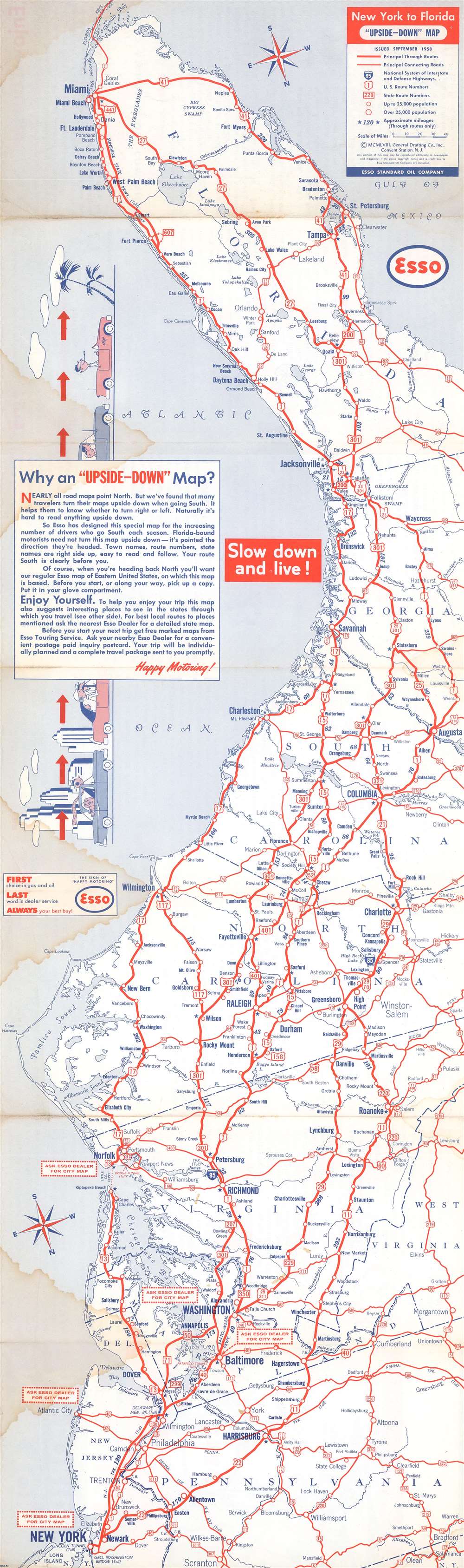
New York to Florida 'Upside-Down' Map.
1958 (dated) 28 x 8.25 in (71.12 x 20.955 cm) 1 : 2534400
1958 (dated) 28 x 8.25 in (71.12 x 20.955 cm) 1 : 2534400
Description
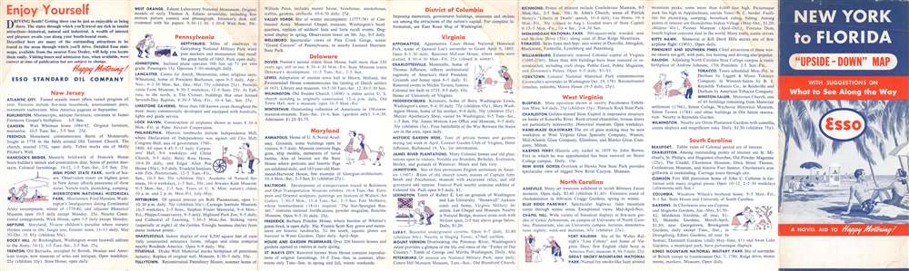
A map with an unusual concept, this 1958 General Drafting Corporation road map of the east coast of the United States is printed upside-down! Created for 'snowbirds' fleeing New York City for the winter, General Drafting discovered that travelers would turn maps upside-down when traveling south, so it was decided that a map should be created accordingly. Here, the southernmost point, the Florida Keys, appear at the top of the map and New York City at the bottom. As jarring as this may seem at first glance, the idea offers a great deal of practical utility. All text is printed correctly (not upside-down like the map's geography), making it fully functional. Major metropolises, such as New York, Washington, D.C., Baltimore, Richmond, Raleigh, Columbia, Jacksonville, and Miami, are highlighted by large bold block letters, while smaller cities and towns throughout the depicted region are labeled by using progressively smaller, less bolded font. All the highways (both federal and state) are marked by red lines and labeled, making the map, as previously stated, easy to use.
Publication History and Census
This map was created by the General Drafting Corporation and published by the Esso Standard Oil Company in 1958. Several editions were published. According to the Map Collection of Yale University Library, Esso first published the 'upside-down' map in 1956, although we have encountered one from 1955. We note a single example of the 1958 edition cataloged in OCLC, which is part of the collection at Utrecht University in the Netherlands.Cartographer
General Drafting Corporation (1909 - 1992) was one of the 'Big Three' publishers of road maps between 1930 and 1970, along with H. M. Gousha and Rand McNally. Founded in 1909, Otto G. Lindberg, an immigrant from Finland and the company's founder, began his business with a borrowed drafting board and a $500 loan from his father. At the time only twenty-three years old, Lindberg advertised his business as 'any and all general drafting' and was based out of 170 Broadway in New York City. Only two years later, in 1911, the firm secured its first contract from the American Automobile Association to make 'road maps'. Lindberg incorporated his business in 1914 and became its first Chairman of the Board, a position he held until his death in 1968. Lindberg persuaded Standard Oil of New Jersey to let him draw the 'best' road map of the state that they had ever seen, and Standard Oil would distribute it for free. Sufficiently impressed with the finished product, Standard contracted General Drafting to make all their road maps - a relationship that lasted another six decades. This relationship allowed General Drafting to work exclusively for Standard Oil, but when oil companies stopped providing free maps, General Drafting was in a bind. The company tried to expand into the retail map market, and it of course continued creating maps for Exxon (the new name for Standard Oil) to sell, but its returns continued to decline. The firm was purchased in 1992 by Langenscheidt and subsequently absorbed into the American Map Company. General Drafting's state maps became this company's 'Travelvision' lineup. More by this mapmaker...
Condition
Average. Exhibits significant dampstaining. Exhibits light wear along original fold lines. Text on verso.
References
OCLC 902605904.