This item has been sold, but you can get on the Waitlist to be notified if another example becomes available, or purchase a digital scan.
1948 Pictorial Map of New York State w/ Parks and Nature Conservancy
NYSOutdoors-seagears-1948$87.50

Title
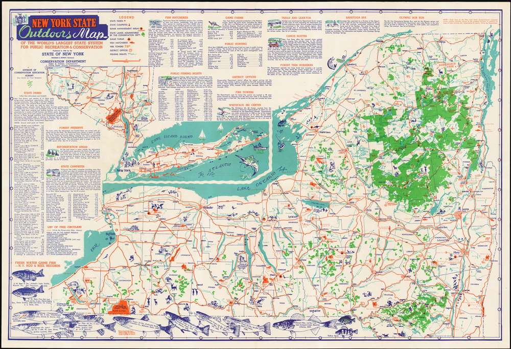
New York State Outdoors Map of the World's Largest State System for Public Recreation & Conservation.
1948 (dated) 19.25 x 28 in (48.895 x 71.12 cm) 1 : 840000
1948 (dated) 19.25 x 28 in (48.895 x 71.12 cm) 1 : 840000
Description
This is a 1948 Map of New York State by illustrator (and New York State Superintendant of Conservation Education) Clayton Seagears, issued by the Conservation Department to promote the public use of New York's 'vast network of State parks,' especially for camping, swimming and fishing. The map is filled with drawings of animals, wildlife scenes, and people enjoying themselves hiking, hunting, canoeing, and even getting a massage in Saratoga Spa. Most of these scenes are drawn in a folksy, cartoonish style - but the map is also decorated with quite realistic drawings of the State's principal fresh water game fish, accompanied by the record catches of those fish, complete with location and date of the catch, weight of the fish, and the names of the lucky fishermen. (Arthur Lawton, for your 1944 catch of a 58 pound St. Lawrence Muskalonge, you are here immortalized.)
The map's central focus is on the vast expanse of upstate New York; an inset map in the upper left details the portions of the State south of Sullivan County, including New York City and Long Island.
Rich in Detail
Printed on the map are extensive lists of state parks, campsites, fishing hatcheries and public fishing grounds, game farms and hunting areas; each listed item bears coordinates allowing easy location on the map. These features are also identified on the map with a key, which additionaly marks lands administered by the Conservation department, district informational offices, and fire towers. Text throughout the map explore aspects of the parks such as its trails, canoe routes, and even an Olympic Bobsled run near Lake Placid.The map's central focus is on the vast expanse of upstate New York; an inset map in the upper left details the portions of the State south of Sullivan County, including New York City and Long Island.
Publication History and Census
This map was produced in one edition, published in 1948 by the State of New York, Conservation Department, Division of Conservation Education. It has been neglected by both institutional collections and the trade, appearing in only seven institutional collections in OCLC and appearing in no auction records or dealers' catalogues.Cartographer
Clayton B. Seagears (1901-1983) was an American artist, writer and naturalist. He served as New York State Superintendent of Conservation until 1960, having joined the department in 1937. In 1946 he founded The Conservationist, the department's magazine. He was a prolific illustrator, his work relating to wildlife and conservation appearing in Collier's, The Saturday Evening Post, American Gun, The Hunter's Encyclopedia and Outdoors Unlimited. In 1953, his design won the national competition for the annual Federal Migratory Bird Hunting and Conservation Stamp. His cartographic work appears to have been limited to a single map: a 1948 map of New York, proudly displaying the state's abundant parks. More by this mapmaker...
Condition
Excellent condition. No staining or wear at folds.
References
OCLC 51182112.