This item has been sold, but you can get on the Waitlist to be notified if another example becomes available, or purchase a digital scan.
1939 Hagstrom Map of Subway and Auto Routes to the New York World's Fair
NYWorldsFairSubwayCar-hagstrom-1939$125.00

Title
New York World's Fair by Subway and Automobile.
1939 (undated) 16.25 x 21.25 in (41.275 x 53.975 cm) 1 : 95040
1939 (undated) 16.25 x 21.25 in (41.275 x 53.975 cm) 1 : 95040
Description
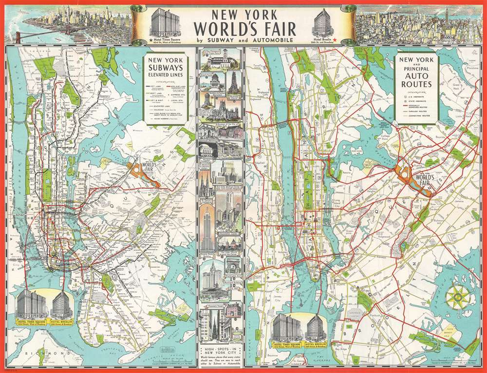
A promotional piece for the 1939 New York World's Fair, this c. 1939 Hagstrom map combines a New York City subway map and a map of road routes to the World's Fair together on one sheet. Both maps illustrate generally the same area from New Jersey to Nassau County on Long Island and from Westchester County to The Narrows. The grounds of the World's Fair in Queens are shaded orange and include an illustration of the Trylon and Perisphere, the monumental constructions that became the symbol of the fair.
More detail is included in New Jersey in the road map, allowing travelers by car to have a better understanding of how to navigate the routes to the fair. On the other hand, significant detail is depicted in the five boroughs of New York City on the subway map, as nearly every subway station is marked, the I.R.T., B.M.T., and Independent lines are illustrated by different colors, and elevated lines (most of which have since been dismantled) are included as well.
Eighteen vignettes sites around Manhattan, including the Metropolitan Museum of Art, the Empire State Building, and Rockefeller Center, separate the two maps. Each vignette is numbered and labeled, with these numbers appearing inscribed in black circles on the auto route map. Other sites, such as Grand Central Terminal and Penn Station, are sketched on the auto route map as well. The Hotel Times Square and the Hotel Breslin are drawn in profile on both maps and marked by stars. They also flank the map's title along the top border. Two aerial views of New York City are also situated along the top border. A view of Lower Manhattan and the Financial District is included on the left, which includes the Brooklyn Bridge. On the right is a view of Midtown looking to the east, with both the Empire State Building and the Chrysler building prominently illustrated. The Trylon and Persiphere are visible on the horizon at the top of the view.
Publication History and Census
This map was created and copyrighted by Hagstrom and distributed by the Hotel Times Square and the Hotel Breslin c. 1939. We have been unable to locate any examples of this map in institutional collections and it is scarce on the private market.Cartographer
Andrew Gunnar Hagstrom (1890 - September 24, 1977) was a map publisher based in Maspeth, Queens. Hagstrom was a Swedish immigrant who came to new York in 1909 where took work milking cows at a farm near Coney Island, Brooklyn. He then worked in the meat packing industry while taking a degree in commercial art at the New York Mechanics Institute. Afterwords he founded a drafting business in Manhattan, creating a map to illustrate his drafting skill help customers locate his shop. His map proved popular and he expanded operations, founding the Hagstrom Map Company (1916 - 1968) and issuing additional maps of various parts of New York City and the surrounding regions. By 1949, Hagstrom had issued more than 150 maps, guides, and atlases, most of which focused on New York. Hagstrom pioneered a cartographic style that exaggerated street size to increase clarity and create additional room for large print readable labeling. Even the New York Subway system hired Hagstrom to produce its map, which was in use from the 1940s to 1958. Hagstrom died in 1977, at the age of 81. Hagstrom was knighted by the King of Sweden. His company flourished until 1968 when it was acquired by Macmillan. The brand has since passed through multiple corporate portfolios and is currently the property by Kappa Publishing Group. More by this mapmaker...
Condition
Very good, Light wear along original fold lines. Text and printed photographs on verso.