This item has been sold, but you can get on the Waitlist to be notified if another example becomes available, or purchase a digital scan.
1906 Donn Map of Oahu, Hawaiian Islands
Oahu-donn-1906$475.00

Title
Oahu Hawaiian Islands.
1906 (dated) 27.25 x 33.5 in (69.215 x 85.09 cm) 1 : 90000
1906 (dated) 27.25 x 33.5 in (69.215 x 85.09 cm) 1 : 90000
Description
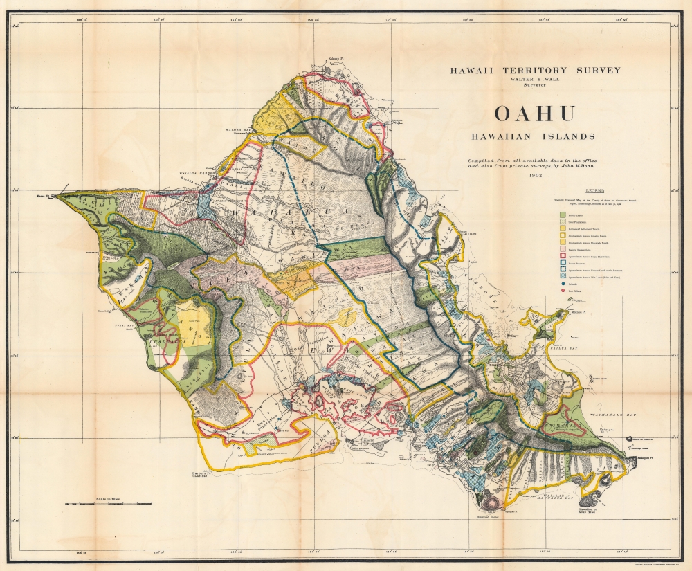
This is a 1906 John M. Donn map of Oahu, Hawaiian Islands. It represents the first comprehensive modern mapping of Oahu.
A Closer Look
Published in a U.S. government report 8 years after the U.S. annexation of Hawaii, this map focuses on land use on Oahu. A legend provides an explanation for the colors employed to highlight public lands, sisal plantations, grazing lands, pineapple lands, federal reserves (i.e. military bases), sugar plantations, forest reserves, and wet lands. Honolulu, Diamond Head, and Pearl Harbor appear in detail. Specific companies and plantations are identified as well, among these are the Waimanalo Sugar Company, the Heeia Agricultural Company, and the Kahuku Plantation.Hawaiian Territorial Survey
The Hawaiian Territorial Survey came into existence in 1901, three years after the United States annexed the archipelago and took the place of the Hawaiian Government Survey. (The Hawaiian Government Survey was created in 1870 to survey the Hawaiian government's land.) In 1901 the Surveyor General of the Hawaiian Government Survey William D. Alexander became the head of the Branch Office of the U.S. Coast and Geodetic Survey in the Hawaiian Islands and Walter E. Wall succeeded him as Territorial Surveyor. The Territorial Survey continued its work until 1959 when Hawaii became a state and thus changed to the State Survey.Publication History and Census
This map was 'compiled from all available data in the office and also from private surveys by John M. Donn' in 1902 and 'specially prepared for Governor's Annual Report, Illustrating Conditions as of June 30, 1906'. We note seven examples cataloged in OCLC: Princeton University, the University of Wisconsin Milwaukee, Brigham Young University, the University of California Berkeley, the University of Hawaii Manoa, the University of California San Diego, and the University of California Davis. An example is also part of the David Rumsey Map Collection.CartographerS
John M. Donn (1871 - August 9, 1931) was an American architect. Donn lived and worked in Washington, D.C., and designed several government buildings. Donn served as the chief draughtsman of the Hawaiian Territorial Survey and was also the Second Assistant. He created a map of Hawaii and a map of Oahu for the Hawaii Territory Survey. He also updated a map of Maui created by the Hawaiian Government Survey. More by this mapmaker...
Walter Eugene Wall (October 13, 1867 - July 23, 1944) was an American surveyor. Born in Yreka, California, he arrived in Honolulu with his parents in 1880. His father was the architect in charge of the construction of the Iolani Palace. He began working at the Hawaiian Government Survey in 1889 and was appointed Territorial Surveyor General in 1901. He worked for the survey for more than 35 years. Wall attended the Ponahou School where he was known for his athletics, introducing the curveball (referenced as 'curve pitching in baseball' in his obituary) to Hawaii. He married Edith Louise Dietz on June 22, 1903. He died in 1944 in Honolulu. Learn More...
Andrew B. Graham (1845 - September 9, 1909) was an American lithographer active in Washington, D.C. in late 19th and early 20th century. Graham was born in Washington D.C., the son of a lithographer and engraver. After college, he joined the U.S. Coast Survey, where he was a draftsman until 1889. He retired from the Coast Survey to take over management of his father's lithography firm. The firm, Andrew B. Graham Company, was one of several that thrived on lucrative government publication contracts. Graham died of 'brain fever' in his Washington D. C. residence on September 9 of 1909. Some of his work was republished posthumously until about 1917, and his firm was active until at least the early 1920s. Learn More...
Source
Governor of Hawaii Board of Indian Commissioners, 'Report of the Governor of Hawaii', Annual Reports of the Department of the Interior for the Fiscal Year Ended June 30, 1906, (Washington: Government Printing Office) 1907.
Condition
Very good. Light wear and some soiling along original fold lines. Verso reinforcements at some fold intersections. Closed margin tear professionally repaired on verso.
References
Rumsey 3705.009. OCLC 225988496, 145505799.