This item has been sold, but you can get on the Waitlist to be notified if another example becomes available, or purchase a digital scan.
1915 Hyde Map of Oak Beach and Lonelyville, New York
OakIslandBeach-hyde-1915$175.00

Title
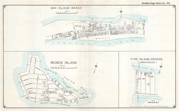
Oak Island Beach. / Muncie Island. / Fire Island Estates (Lonelyville).
1915 (dated) 16 x 26 in (40.64 x 66.04 cm)
1915 (dated) 16 x 26 in (40.64 x 66.04 cm)
Description
This is a 1915 E. Belcher Hyde set of three maps of Jones Beach Island and Fire Island, New York, printed on one sheet and depicts the communities of Oak Beach (Oak Island Beach) and Lonelyville (Fire Island Estates – Lonelyville) and Muncie Island. The map along the top of the sheet illustrates Oak Beach (Oak Island Beach) from the residence of Dr. H. Keyes to Adams Street and from Coolies Channel to the Atlantic Ocean. Each street within the community is labeled, and numerous private residences are labeled with their occupant's name. Each lot is illustrated as is the location of the house. The Bath House and hotel on the outskirts of town are also illustrated and labeled, as is the government dock.
The map on the lower left depicts Muncie Island in a similar manner. Each street is labeled, as are the residences of the island's nearly two-dozen households. The Muncie Island Hotel and Casino are illustrated and labeled on the extreme right side of the island. The map of Fire Island Estates (Lonelyville) is situated in the lower right corner. Depicting the community in the same way as the other two, each of the streets is illustrated, though they remain unlabeled, and the residences of the ten households are illustrated and identified by their owners. A railroad runs through the community from the dock on the Great South Bay to the pier on the Atlantic Ocean. The Fire Island Fishing Company is also labeled, though it is unclear exactly how much real estate they occupy.
This map was created and published by the E. Belcher Hyde Company of Brooklyn, New York in 1915.
Cartographer
Hyde and Company (fl. c. 1880 - 1920) (a.k.a. E. Belcher Hyde Map Company) was a Brooklyn, New York, publisher of maps and atlases. Hyde's work primarily focused on Long Island and the fire insurance industry, which required highly detailed maps of cities and towns in order to assess risk and liability. Many of Hyde's maps offered incredible detail at a large scale, including annotations on property owners, building materials, size, and function. While Long Island was the focus of most of the firm's efforts, it also produced atlases of the greater New York City metropolitan area, including the Bronx, Queens, Manhattan, and Westchester. More by this mapmaker...
Condition
Very good. Verso repairs to centerfold separations. Blank on verso.