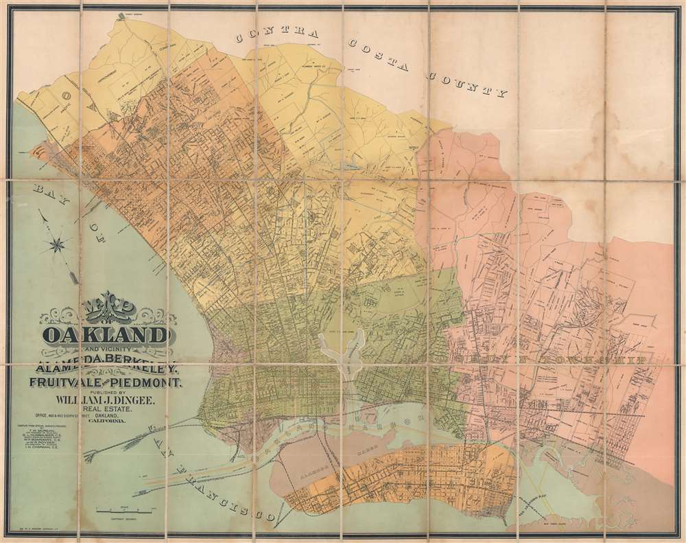
1892 Dingee City Plan or Map of Oakland and the East Bay, California
OaklandVicinity-dingee-1892$3,750.00


Title
Map of Oakland and Vicinity. Alameda, Berkeley, Fruitvale, and Piedmont.
1892 (dated) 27 x 34.25 in (68.58 x 86.995 cm) 1 : 23040
1892 (dated) 27 x 34.25 in (68.58 x 86.995 cm) 1 : 23040
Description
This is a c. 1892 William J. Dingee city plan or map of Oakland, California, and the surrounding East Bay area. Published just before Oakland experienced a decades-long boom following the Panic of 1893 in which the city became in industrial center, streets are illustrated and labeled throughout Oakland, Berkeley, Albany (incorporated in 1908), Emeryville (incorporated in 1896), Piedmont, Alameda, and Brooklyn Township.
A Chronicle of Land Ownership
City blocks are numbered throughout the region. Tracts and grants previously owned by private citizens throughout Oakland, Berkeley, and the other communities are superimposed over this street grid. However, the street grid had not yet reached areas farther from downtown Oakland or Berkeley. For example, large tracts of land in what is today Albany, are owned by the Pacific Improvement Company, an affiliate of the Southern Pacific Railroad. The Alameda Water Company and the Contra Costa Water Company owned land east of the city as well. This map's publisher, William J. Dingee, also owned large parts of Oakland and Brooklyn Townships. Part of Berkeley is reserved for the 'State University' (which we know today as the University of California, Berkeley). The Mountain View Cemetery, designed by famed landscape architect Frederick Law Olmstead, appears as well.A City on the Rise
Dingee published this map when Oakland was about to become one of the most important industrial cities in the western United States. Between 1900 and 1930, Oakland was one of the three fastest growing cities in the United States, growing from 67,000 residents to 284,000. This rise was driven by Oakland's history as a railroad hub and the penultimate stop for travelers from the East Coast along with the arrival of new railroads in the Santa Fe and the Western Pacific. Oakland's already robust railroad and streetcar network is illustrated here by dashed black and white lines. Among these are routes operated by the California and Nevada Railroad, the Central Pacific Railroad, and the Highland Park and Fruitvale Railroad. The region's burgeoning industrial might is not highlighted here, but its many churches, schools, and government buildings are noted.Publication History and Census
This map was published by William J. Dingee and lithographed by the H.S. Crocker Company c. 1892. We note a single cataloged example, which is part of the collection at the Huntington Library.CartographerS
William Jackson Dingee (July 22, 1854 - September 5, 1941) (pronounced 'dingy') was an American real estate magnate and utility owner. Born in Pennsylvania, Dingee moved to Oakland, California in 1877 and found a job as a bookkeeper. Between 1878 and 1888, Dingee became wealthy investing in real estate. By 1888 he was living at the Fernwood Estate (the former residence of Colonel Jack Coffee Hays). In 1891, Dingee approached the Contra Costa Water Company to service his acreage in the Montclair - Piedmont area. Contra Costa refused, purportedly because of the company's supply problems. (Water in the East Bay was scarce) In response, Dingee drilled tunnels into the hills on his estate above Shepherd Canyon to access aquifers. To offset this venture, he extended the pipes past his Piedmont property into the Oakland flatlands, areas poorly serviced by the Contra Costa Water Company. In doing so he formed the Piedmont Spring and Water Company in 1891 and then in the Oakland Water Company in 1893. In doing so, he became a direct competitor with the Contra Coast Water Company. These events ignited the infamous 'Water War' of the late 19th century. The companies slashed prices to compete and hired 'experts' to denigrate one-another's water, claiming it was 'not fit for human consumption'. Both companies suffered sabotage, for which they publicly blamed each other. The war led to severe water shortages throughout Oakland such that it was impossible to get water to the upper floors of downtown buildings in the afternoon. Even City Hall had to use pitchers to get water to the second floor. Finally, in 1888 or 1889, under city pressure, the companies consolidated under Dingee. At the end of the Water War, Dingee was a millionaire and owned property in both Oakland and New York. His Fernwood Estate burned to the ground in 1899 while he and his wife were in New York. Around this time, Dingee invested the cement industry, opening plants in California, Pennsylvania, and Washington. He came to be known as 'The Cement King'. Dingee's fortune evaporated in 1908, supposedly because of a corrupt business partner. Humbled, he and his wife moved to Sacramento. His wife died of pneumonia in 1914 and he entered bankruptcy court in 1921. Dingee died in obscurity in 1941. More by this mapmaker...
Henry Smith Crocker (January 31, 1832 - July 18, 1904) was an American printer, publisher, and railroad investor active in northern California in the middle to late 19th century. Crocker followed the Gold Rush to California, settling in Sacramento in the 1850s. He established his printing concern, H. S. Crocker, in 1856. Apparently his first office was little more than a tent with a small sign. Crocker relocated to San Francisco in 1871. He became extremely wealthy almost overnight by leveraging his ties to the Central Pacific Railroad, which is brother, Charles Crocker (1822 - 1888) founded. In 1885, Crocker constructed a large five-story printing factory, powered by his own private steam plant, then the largest and most sophisticated printing concern on the west coast. Crocker's prosperity continued and by the time he died in 1904, he was the head of a large and wealthy family. Although Crocker passed on, his company, H.S. Crocker, continued to operate and remains active to this day. Learn More...
Condition
Good. Dissected and mounted on linen in twenty-four (24) panels. Soiling.
References
Huntington Library Call Number 151606.