This item has been sold, but you can get on the Waitlist to be notified if another example becomes available, or purchase a digital scan.
1897 Garcia Cubas Map of Oaxaca
Oaxaca-garciacubas-1897$300.00

Title
Oaxaca.
1897 (dated) 15.5 x 22 in (39.37 x 55.88 cm) 1 : 100000
1897 (dated) 15.5 x 22 in (39.37 x 55.88 cm) 1 : 100000
Description
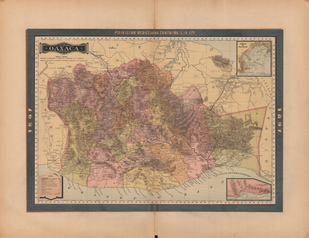
A lovely map of Oaxaca, Mexico, published in 1897 as part of the Atlas Geográfico de los Estados Unidos Mexicanos. It highlights the significant changes taking place in the state at the time, including the construction of a railway linking the Atlantic and Pacific Oceans across the Isthmus of Tehuantepec.
The railway line leading east out of Tehuantepec into Chiapas was completed and integrated into the Ferrocarril Transístmico. However, the line proposed here leading south from Oaxaca City to the Pacific coast via Miahuatlán to Huatulco was never constructed.
As with most other parts of Mexico, Oaxaca suffered from the political upheaval, civil wars, and foreign interventions of the 19th and early 20th centuries. Oaxaca underwent a fairly typical experience during the Porfiriato (1876 - 1911), with investment in infrastructure and modernization efforts producing tangible results, but which also mainly benefitted wealthy Mexicans and foreigners, and relied on exploitative labor practices that angered the working masses.
A Closer Look
Districts and municipalities are color shaded for easy differentiation. Roads, railways (existing and proposed), cities and towns, haciendas, ranchos, ports, waterways, and the lush, abundant mountains of Oaxaca are all represented. An inset map and nautical chart of the Bay of Salina Cruz, Oaxaca's main port, appears at bottom-right. At top-right, a similar map and chart of the Bay of Huatulco is presented. As with other maps in the Atlas Geográfico, longitude is measured from Mexico City.Opening Up Oaxaca
The completed railway line towards top which zig-zags through the mountains is the Ferrocarril Mexicano del Sur (opened 1892), which originated in Mexico City. The railway at right noted as under construction (dashed line) is the Ferrocarril Nacional de Tehuantepec, now known as the Ferrocarril Transístmico. When it opened in 1907, it completed a link across the Isthmus of Tehuantepec that had been discussed for nearly a century, and which at times seemed a contender to rival planned railways and canals in Nicaragua and Panama. Though it never quite matched the Panama Canal in importance, it did significantly expedite the export of raw materials from Oaxaca and elsewhere, allowing quick transit to either the Atlantic or Pacific, and turned Tehuantepec into a boom town in the early 20th century.The railway line leading east out of Tehuantepec into Chiapas was completed and integrated into the Ferrocarril Transístmico. However, the line proposed here leading south from Oaxaca City to the Pacific coast via Miahuatlán to Huatulco was never constructed.
Oaxaca at Center Stage
Oaxaca and Oaxacans played a central role in Mexico's political fortunes in the second half of 19th century. In particular, the two towering figures of Mexican politics of the time, Benito Juárez (1806 - 1872) and Porfirio Díaz (1830 - 1915), were born, raised, and began their political careers in the state. Aside from his other accomplishments, Juárez was, like much of the population in Oaxaca, of indigenous heritage, and became the first indigenous president of Mexico (or anywhere else in the Americas).As with most other parts of Mexico, Oaxaca suffered from the political upheaval, civil wars, and foreign interventions of the 19th and early 20th centuries. Oaxaca underwent a fairly typical experience during the Porfiriato (1876 - 1911), with investment in infrastructure and modernization efforts producing tangible results, but which also mainly benefitted wealthy Mexicans and foreigners, and relied on exploitative labor practices that angered the working masses.
Publication History and Census
This map was published in Mexico City in 1897 by Vega y Cie. It was originally prepared in 1886 for Antonio García Cubas' Atlas geografico y estadistico de los Estados Unidos Mexicanos and was updated with additional border work for the 1897 issue of the Atlas Geográfico de los Estados Unidos Mexicanos. The atlas is represented in several institutional collections but is extremely scarce on the market. The individual maps, likewise, are scarce to the market.Cartographer
Antonio Garcia y Cubas (July 24, 1832 - February 9, 1912) was a Mexican cartographer, writer, engineer, and geographer active in Mexico City in the second half of the 19th and the early 20th centuries. He is considered Mexico's first great geographer. Garcia y Cubas was born in Mexico City. He was orphaned at birth and was raised by is aunt. When he turned 18, he enrolled in the Dirección General de Industria, a government sponsored technical school. There he studied engineering and geography, which he further pursued at the Colegio de San Gregorio, Colegio de Ingenieros. He graduated with honors in geography and from 1856, became a member of the Sociedad Mexicana de Geografía y Estadística. His geographical work earned him the Order of Guadalupe, a Mexican second empire honorific, directly from the Emperor Maximillian. He published several atlases, including his important Atlas Geográfico, Estadístico e Histórico de la República Mexicana, and multiple decorative chromolithograph Atlas Pintoresco e Históricos covering Mexico, Cuba, Spain, and elsewhere. Today his work is scarce and highly desirable. More by this mapmaker...
Source
García Cubas, Antonio, Atlas Geográfico de los Estados Unidos Mexicanos, (Mexico City: Vega) 1897.
Atlas Geográfico de los Estados Unidos Mexicanos is a grand-format folio atlas of Mexico. It is based largely upon the Atlas Geográfico y Estadístico de los Estados Unidos Mexicanos published in 1887 by Antonio García Cubas and Debray. The present atlas incorporates the same maps, but adds a dramatic silver and gold border, which obscures the 1886 García Cubas imprint. It was issued during Porfirio Díaz's third term as president of Mexico - a period marked by rapid expansion of infrastructure and industry, including railroads, mines, bridges, roads, and broad scale electrification and waterworks. The atlases title page in this 1897 edition, celebrates Diaz with a large portrait and dedication. We have identified at least two editions of this atlas, both bearing the 1897 date: one by Cadena y Cie, features a red title page, another by Vega y Cie, featuring a blue title page. All 1897 editions we have identified have the silver borders, but these seem to be overprinted to cover an earlier gold border, with unidentifiable text and dating behind. We have been unable to find any examples with only the gold border. The atlases in general are showpieces of Mexican lithography in the golden age of the Porfiriato.
Condition
Good. Wear along centerfold, which is reinforced on verso. Minor marginal tears professionally closed on verso. Chip along bottom edge near center.
References
Rumsey 5758.015 (1886 Edition).