This item has been sold, but you can get on the Waitlist to be notified if another example becomes available, or purchase a digital scan.
1780 Raynal and Bonne Map of Great Lakes and Upper Mississippi
OccidentileCanada-bonne-1780$200.00

Title
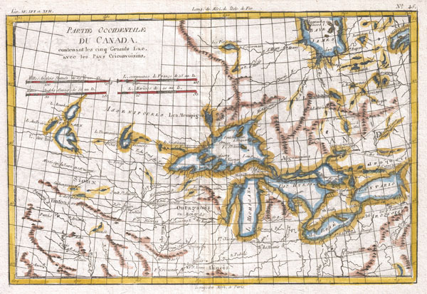
Partie Occidentale Du Canada, Contenant Les Cinq Grands Lac, Avec Les Pays Criconvoisins
1780 (undated) 9 x 13 in (22.86 x 33.02 cm)
1780 (undated) 9 x 13 in (22.86 x 33.02 cm)
Description
A fine example of Rigobert Bonne and Guilleme Raynal's 1780 map of the Great Lakes and upper Mississippi Valley. A map of considerable importance, this chart was constructed during a period of aggressive exploration into this region. Explorers, seeking a 'westward passage' to the Pacific, believed an inland water route was not only reasonable, but highly likely. With no concept that the vast barrier of the Rocky Mountains stood in their way, they mapped out the likely courses for this route, as depicted on this map. They believed one could pass through the Great Lakes and, roughly following the current US-Canada border, pass upriver to Rainey Lake (L. Tecamamiouen)and then, through another River, to the Lake of the Woods (Lac des Bois), then, via another river, to (though it does not appear on this map) Lake Winnipeg. Here the water route westward ends - though at the time they didn't know it. Throughout this map, Bonne attempts to document rivers, mountains, forts, and American Indian tribes and villages with the most recent data obtainable. He identifies the lands of the Sioux, the Iroquois (Five Nations), the Algonquians, the Illinois, and many others. Chicago (Chicagou) and Detroit both appear as forts. The Great Lakes are mapped with a rough approximation of accuracy, though Lake Superior does include a number of apocryphal islands including I. Ponchartrain and I. Minong (also known as Phillipeaux). These islands first appeared Bellin's mapping of the region in 1750s and continued to appear until the 1820s. Also of note are the possible headwaters of the Mississippi, which the map describes as 'La Source en est inconnue.' Atlas de Toutes les Parties Connues du Globe Terrestre, Dressé pour l'Histoire Philosophique et Politique des Établissemens et du Commerce des Européens dans les Deux Indes.
Cartographer
Rigobert Bonne (October 6, 1727 - September 2, 1794) was one of the most important French cartographers of the late 18th century. Bonne was born in Ardennes à Raucourt, France. He taught himself mathematics and by eighteen was a working engineer. During the War of the Austrian Succession (1740 - 1748) he served as a military engineer at Berg-op-Zoom. It the subsequent years Bonne became one of the most respected masters of mathematics, physics, and geography in Paris. In 1773, Bonne succeeded Jacques-Nicolas Bellin as Royal Cartographer to France in the office of the Hydrographer at the Depôt de la Marine. Working in his official capacity, Bonne compiled some of the most detailed and accurate maps of the period - most on an equal-area projection known erroneously as the 'Bonne Projection.' Bonne's work represents an important step in the evolution of the cartographic ideology away from the decorative work of the 17th and early 18th century towards a more scientific and practical aesthetic. While mostly focusing on coastal regions, the work of Bonne is highly regarded for its detail, historical importance, and overall aesthetic appeal. Bonne died of edema in 1794, but his son Charles-Marie Rigobert Bonne continued to publish his work well after his death. More by this mapmaker...
Source
Raynal, G., Atlas de Toutes les Parties Connues du Globe Terrestre, Dressé pour l'Histoire Philosophique et Politique des Établissemens et du Commerce des Européens dans les Deux Indes, 1780.
Condition
Very good. Original centerfold. Platemark visible. Blank on verso.
References
Sellers, J. R. and Van Ee, P. M., Maps and Charts of North America and the West Indies 1750-1789, 173. Kershaw, K., Early Printed Maps of Canada, nos. 973-976.