1874 Tardieu Map of Australia and the Pacific Ocean
Oceanie-tardieu-1874$125.00

Title
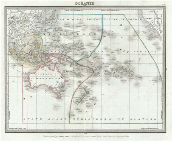
Oceanie.
1874 (undated) 14.5 x 17.5 in (36.83 x 44.45 cm) 1 : 32000000
1874 (undated) 14.5 x 17.5 in (36.83 x 44.45 cm) 1 : 32000000
Description
This is a fine 1874 map of the Pacific Ocean, including Australia, Polynesia, Melanesia and Malaysia by Ambroise Tardieu. It covers the region in considerable detail with parts of North America and Asia included. Extends as far north as Japan and south to include Auckland Island and New Zealand. This map depicts the continent of Australia with good detail along the coast with a largely unexplored interior. This map also identifies various cities, towns, rivers and an assortment of additional topographical details. This map was prepared by Ambroise Tardieu as plate no. 25 and issued in his 1874 edition of Atlas Universel de Geographie Ancienne et Moderne.
CartographerS
Ambroise Tardieu (March 2, 1788 - January 17, 1841) was a prominent French cartographer and engraver operating in the late 18th and early 19th centuries. He was member of the large and prolific Tardieu family, which, for over 200 years, produced multiple skilled and active engravers. Tardieu's work is known for its beauty and accuracy as well as for its depth of detail. Tardieu's most important work is his version of John Arrowsmith's large format map of the United States, published in 1806. Ambroise Tardieu is eclipsed in fame by his son, artist and medical scholar, August Ambroise Tardieu. Ambroise Tardieu is also frequently confused with Jean Baptiste Pierre Tardieu, another unrelated French map and print engraver active in the early 19th century. More by this mapmaker...
Alexandre Aimé Vuillemin (1812 - 1880) was an engraver, publisher, and editor based in Paris, France in the middle of the 19th century. Despite a prolific publishing career, much of Vuillemin's life is shrouded in mystery. In 1852, he married Josephine Caroline Goret and they had at least one child, Ernestine Adèle Vuillemin, later in the same year. What is known is that his studied under the prominent French Auguste Henri Dufour (1798 - 1865). Vuillemin's most important work his detailed, highly decorative large format Atlas Illustre de Geographie Commerciale et Industrielle. Learn More...
Source
Furne, Jouvet et Cie Atlas Universel de Geographie Ancienne et Moderne (Paris), 1874.
Condition
Very good. Minor wear along original centerfold. Original platemark visible. Minor spotting.
References
Rumsey 4697.031 (1863 edition).