1863 Mitchell Map of Ohio and Indiana
OhioIndiana-mitchell-1863$100.00

Title
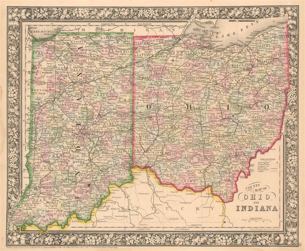
County Map of Ohio and Indiana.
1863 (dated) 11.5 x 14 in (29.21 x 35.56 cm) 1 : 1800000
1863 (dated) 11.5 x 14 in (29.21 x 35.56 cm) 1 : 1800000
Description
This is an 1863 Samuel Augustus Mitchell, Jr. map of Ohio and Indiana. The map depicts the region from Illinois to Pennsylvania and Virginia and from Lake Michigan, the State of Michigan, and Lake Erie to Kentucky and Virginia.
The Wabash and Erie Canal and the Miami and Erie Canal
Perhaps the most important aspect of this map is the illustration of the Wabash and Erie Canal. The canal connected the Great Lakes to the Ohio River, which established a direct waterway from the Great Lakes to the Gulf of Mexico. Although the canal was known as the Wabash and Erie (that label does not appear here), it was actually a combination of four canals: the Miami and Erie Canal from Toledo, Ohio to Junction Ohio; the original Wabash and Erie Canal from Junction, Ohio to Terre Haute, Indiana; the Cross Cut Canal from Terre Haute, Indiana to Worthington, Indiana; and the Central Canal from Worthington, Indiana to Evansville, Indiana. At over 460 miles long, the Wabash and Erie Canal was the longest canal constructed in North America. The Miami and Erie Canal, which also connected Lake Erie and the Ohio River, cut south across the state from Defiance, Ohio to Cincinnati, Ohio. The canals were hard pressed to compete with the newly - expanding (and much faster) railroads. Despite this competition, the canals survived until the early 1900s and then ceased operations due to decline in use and high operating costs.Colorful and Informative
Individual counties are illustrated, labeled, and shaded different colors to allow for easy differentiation in both Indiana and Ohio. Cities, such as Toledo, Cleveland, Cincinnati, Columbus, Indianapolis, Terre Haute, and Evansville are labeled, along with myriad other towns and villages. Rivers, creeks, and lakes are illustrated as well, though not all are labeled.Publication History and Census
This map was prepared by S. A. Mitchell Jr. for inclusion in the 1863 edition of Mitchell's New General Atlas. The work was successful and examples of the map appear on the market, although separate examples of the map are scarce in institutional collections. The atlas is well represented in OCLC.Cartographer
Samuel Augustus Mitchell (March 20, 1792 - December 20, 1868) began his map publishing career in the early 1830s. Mitchell was born in Bristol, Connecticut. He relocated to Philadelphia in 1821. Having worked as a school teacher and a geographical writer, Mitchell was frustrated with the low quality and inaccuracy of school texts of the period. His first maps were an attempt to rectify this problem. In the next 20 years Mitchell would become the most prominent American map publisher of the mid-19th century. Mitchell worked with prominent engravers J. H. Young, H. S. Tanner, and H. N. Burroughs before attaining the full copyright on his maps in 1847. In 1849 Mitchell either partnered with or sold his plates to Thomas, Cowperthwait and Company who continued to publish the Mitchell's Universal Atlas. By about 1856 most of the Mitchell plates and copyrights were acquired by Charles Desilver who continued to publish the maps, many with modified borders and color schemes, until Mitchell's son, Samuel Augustus Mitchell Junior, entered the picture. In 1859, S.A. Mitchell Jr. purchased most of the plates back from Desilver and introduced his own floral motif border. From 1860 on, he published his own editions of the New General Atlas. The younger Mitchell became as prominent as his father, publishing maps and atlases until 1887, when most of the copyrights were again sold and the Mitchell firm closed its doors for the final time. More by this mapmaker...
Source
Mitchell, S. A. New General Atlas Philadelphia, 1863.
Condition
Very good. Wear to lower left corner away from image, few spots.
References
OCLC 7124377.