This item has been sold, but you can get on the Waitlist to be notified if another example becomes available, or purchase a digital scan.
1945 XXIV Corps Intelligence Section Map of Southern Okinawa During WWII
OkinawaNaha-xxivcorps-1945$1,375.00

Title
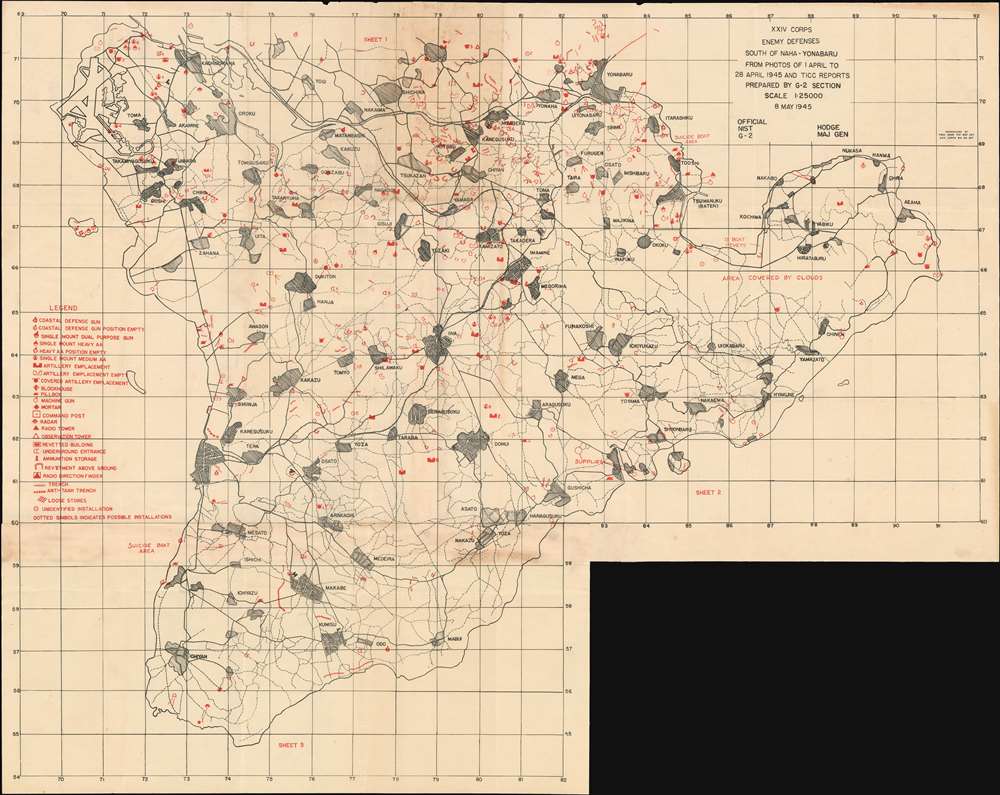
XXIV Corps. Enemy Defenses South of Naha-Yohabaru. From Photos of 1 April to 28 April 1945 and TICC Reports.
1945 (dated) 27 x 34 in (68.58 x 86.36 cm) 1 : 25000
1945 (dated) 27 x 34 in (68.58 x 86.36 cm) 1 : 25000
Description
A rare 1945 World War II military intelligence map of southern Okinawa likely created by American intelligence officers from a captured Japanese map. This 1945 XXIV Corps Intelligence Section map was prepared to support what would become the last major battle of the Pacific War. Red overprinting highlights the known Japanese defensive positions from Yonabaru to the southern tip of the island. A legend situated along the left border details twenty-six types of Japanese military installations, including coastal guns, three different types of artillery emplacements, pillboxes, mortars, machine guns, and command posts. Japanese trenches and anti-tank defenses are also marked. Two text notes printed along the coastline near Itarashiku and Mesato, respectively, read 'Suicide Boat Area', which refer to Japanese Shin'yō-class motorboats. These boats were part of a Japanese program to create suicide craft, which included kamikaze planes, kaiten submarines, fukuryu suicide divers, and the shinyo boats. They were operated by one man, could travel up to thirty knots, and carried up to 300 kilograms (660 pounds) of explosives in their bow, which could either be detonated by the driver or on impact.
The XXIV Corps and the Creation of This Map
In the XXIV Corps Action Report summarizing the Ryukyus campaign from 1 April 1945 - 30 June 1945, Lieutenant General John R. Hodge, the commanding officer of the XXIV Corps, refers to the creation of a map very similar to the present map in the chapter discussing Intelligence. It readsA captured Jap map scale 1 : 25,000 was reproduced and distributed to divisions and Corps troops. Later on the map was annotated with place names and blown up to 1 : 10,000 for use in small units. Corps Artillery reported an accuracy of 200 yards or less in horizontal control and a fair degree of accuracy in vertical control. The original Jap map was dispatched by air to CinCPac [Commander in Chief Pacific] and a revised 1 : 25,000 map was issued based on this map and latest photos. Corps Artillery reported its mean accuracy to within five yards in both horizontal and vertical control.While it is impossible to know with certainty that the present map is an example of the 1 : 25,000 scale map referenced here by General Hodge, several details suggest this to be the case. First, the scales match. Second, the map was prepared from aerial photographs taken as late as April 28, and with a publication date of May 8, that certainly counts as the latest photographs in 1945. Third, the map states that it was prepared by the G-2 Section, an Army abbreviation for the Intelligence Section. Lastly, the map was reproduced by the Provisional Engineer Topographical Map Detachment of the XXIV Corps, as noted along the right border in small print. With a map of this sensitivity, it is likely that CinCPac would have sent only a master copy to Okinawa if the XXIV Corps had the capability of printing copies themselves, which it appears they did.
A third revision of the 1 : 25,000 map was issued late in May. This became the official operations map. It was later blown up to a scale of 1 : 10,000 and distributed to company commanders and platoon leaders. It is suggested that in future map revisions where captured maps are available, the hill numbers and correct town names be included in the revision. Jap maps of OKINAWA contained hill numbers and in many instances correct names of towns as well as names of towns not shown on our maps.
The Battle of Okinawa
The Battle of Okinawa raged from April 1, 1945 until June 22, 1945. Codenamed Operation Iceberg, the invasion of Okinawa took place on the morning of April 1 and was the largest amphibious assault in the Pacific Theater. The Allies intended to use Okinawa's Kadena Air Base as a launching point for the upcoming invasion of the Japanese home islands, Operation Downfall. The battle has earned the nickname the 'typhoon of steel' due to the ferocity of the fighting, the number of Allied ships and tanks that participated, and the intensity of the Japanese kamikaze attacks. The Japanese surrender following the bombings of Nagasaki and Hiroshima eliminated the need to proceed with the Operation Downfall home islands invasion.Publication History and Census
This map was created by the G-2 Section and printed by the Provisional Engineer Topographical Map Detachment of the XXIV Corps. This is the only known surviving example.Condition
Very good. Exhibits some toning and soiling. Light wear along original fold lines. Closed tear extending 1.5 inches into printed area from bottom border professionally repaired on verso. Does not effect island. Blank on verso.