This item has been sold, but you can get on the Waitlist to be notified if another example becomes available, or purchase a digital scan.
1940 Nelson Pictorial Map of 'Old Chicago', Illinois
OldChicago-nelson-1940$475.00

Title
Old Chicago.
1940 (dated) 29.75 x 35.5 in (75.565 x 90.17 cm)
1940 (dated) 29.75 x 35.5 in (75.565 x 90.17 cm)
Description
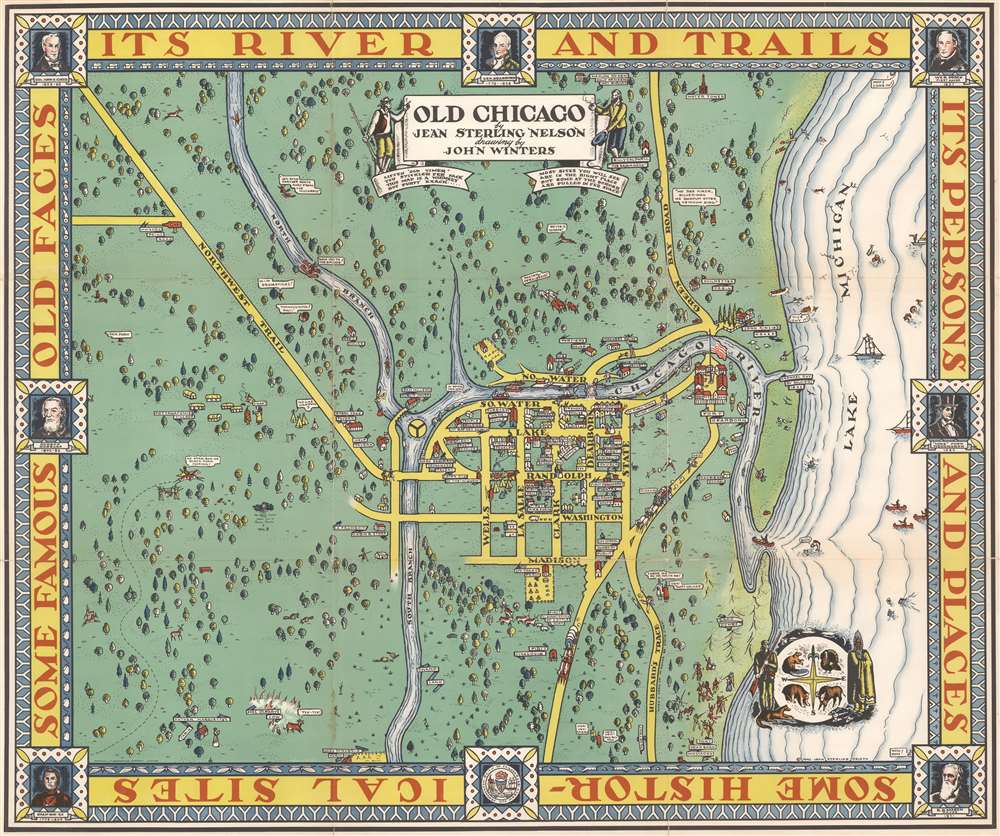
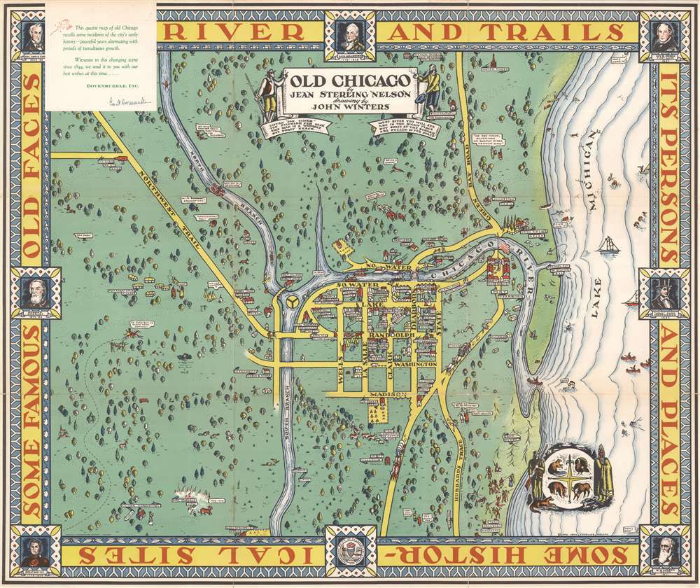
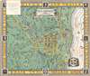
This is a rare 1940 Jean Sterling Nelson and John Winters pictorial map of historic Chicago, Illinois. Nelson and Winters focus on illustrating Chicago in the first half of the 19th century, when it was a fledgling city on the very edge of civilization. The city's historic center, from South Water Street to Madison Street and from the South Branch of the Chicago River to State Street and Fort Dearborn farther east, exhibits an emerging urban grid. Many of Chicago's 'firsts' are illustrated, including the first post office, the first Catholic church (St. Mary's), the first Presbyterian church, the first jail and courthouse, the first permanent theatre, and the first public school. Outside this area, Chicago's first synagogue (built in 1849) is also illustrated (this is now the federal building, per the map), along with the water tower, Mary Todd Lincoln's 1866 home, and Mrs. O'Leary's Cow (supposedly started the Great Chicago Fire). Explorers, ranchers, Native Americans, and frontiersmen populate the map. Portraits of notable early Chicagoans, including John B. Kinzie, General Dearborn, and William B. Ogden adorn the border, along with text that reads 'Its River and Trails, its Persons and Places, some Historical Sites, some Famous Old Faces.'
Publication History and Census
This map was drawn by John Winters and published by Jean Sterling Nelson in 1940. We note two examples cataloged in OCLC, located at the Newberry Library and the Wisconsin Historical Society. We note a third cataloged example at the University of Wisconsin Milwaukee.CartographerS
Jean Sterling Nelson (1885 - 19xx) was an American interior designer and lecturer at the Chicago Art Institute. She was the daughter of immigrants and spent her entire life in Illinois. She received a bachelor's degree in Philosophy from the University of Chicago in 1907 and lived at 3202 Dearborn Street from 1910 until 1913 according to the University of Chicago Alumni Directory. She made one map: a pictorial map of Chicago entitled 'Old Chicago'. In 1951, Nelson was a patient at the 28-K infirmary at Oak Forest (a suburb of Chicago) and apparently read the entire Chicago Tribune to fellow patients every morning. A letter to the editor and publisher of the Tribune written by Nelson got a film of General MacArthur's visit to the U.S. in 1951 shown at the 28-K infirmary. More by this mapmaker...
John Richard Winters (May 12, 1904 - February 28, 1983) was an American artist. Born in Omaha, Nebraska, Winters established himself as an integral part of the Chicago art scene during the 1930s and 1940s. He was a talented, diverse, and extremely prolific artist. Over the course of his career, he worked as a newspaper photographer, executed countless murals, and worked as an administrator for WPA Illinois Art Project. He briefly taught art and design at the Layton School of Art in Milwaukee and Kansas State University in Manhattan, Kansas, before beginning a career as the chief artist/designer in the display department of Wanamaker's in Philadelphia in 1948. He retired in 1973. Learn More...
Condition
Good. Wear along original fold lines. Verso repairs to fold separations. Closed margin tears professionally repaired on verso. Old tape repairs evident on verso. Slight loss at some fold intersections.
References
OCLC 52525927.