This item has been sold, but you can get on the Waitlist to be notified if another example becomes available, or purchase a digital scan.
1886 Walling Map of the Old Colony Railroad, Cape Cod, Martha's Vineyard
OldColonyLine-walling-1886$375.00

Title
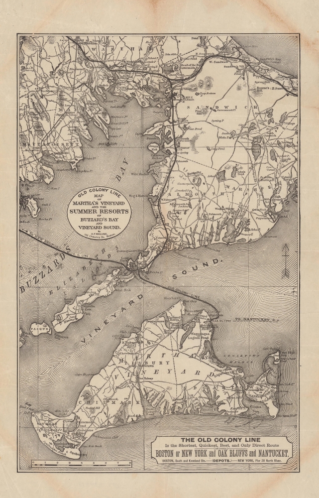
Old Colony Line map of Martha's Vineyard and the summer resorts of Buzzard's Bay and Vineyard Sound.
1886 (undated) 14 x 9 in (35.56 x 22.86 cm) 1 : 165000
1886 (undated) 14 x 9 in (35.56 x 22.86 cm) 1 : 165000
Description
A c. 1886 Henry Francis Walling map of southern Cape Cod and Martha's Vineyard, highlighting the Old Colony Railroad network. It captures the region as it transitioned from whaling to tourism-based economies. The Old Colony network is illustrated near its height, with rail service to Cape Cod, ferry service to Martha's Vineyard, and a short-lived narrow-gauge railway on Martha's Vineyard itself.
This map was issued as Martha's Vineyard was transitioning from a whaling to tourism economy. The Old Colony system was an essential part of this transition, bringing in well-heeled tourists from throughout New England and beyond.
Aside from rail and ferry lines, roads, waterways, islands, beaches, and other features are indicated throughout, including 'Indian Lands' on the west side of Martha's Vineyard. This area was then known as Gay Head but has recently been officially renamed to its historic indigenous name, Aquinnah, and continues to serve as an important cultural center for the Wampanoag people.
A Closer Look
Focusing on the lands around Buzzard's Bay and Vineyard Sound, this map highlights lines belonging to the Old Colony Railroad, at the time one of the largest rail systems in New England. Lines extending from Falmouth on Cape Cod and to New Bedford, beyond the map's scope to the west, are not rail lines but ferry services (operated as a subsidiary, the Old Colony Steamboat Company). However, once passengers reached Oak Bluffs on Martha's Vineyard, they could board a narrow-gauge railroad to Katama Point in Edgartown. This line operated from 1874 to 1896 and was run by the Old Colony Railroad in its final years.This map was issued as Martha's Vineyard was transitioning from a whaling to tourism economy. The Old Colony system was an essential part of this transition, bringing in well-heeled tourists from throughout New England and beyond.
Aside from rail and ferry lines, roads, waterways, islands, beaches, and other features are indicated throughout, including 'Indian Lands' on the west side of Martha's Vineyard. This area was then known as Gay Head but has recently been officially renamed to its historic indigenous name, Aquinnah, and continues to serve as an important cultural center for the Wampanoag people.
The Old Colony Railroad
Founded in 1845, the Old Colony Railroad operated in southeastern Massachusetts and parts of Rhode Island until 1893. Named after the 'Old Colony,' a reference to Plymouth, its network grew extensively through mergers and acquisitions. Old Colony operated both passenger and freight services, as well as steamship service to New York City. A steamer between Woods Hole, Martha's Vineyard, and Nantucket also operated from 1872. The New York, New Haven, and Hartford Railroad acquired the Old Colony trackage rights in 1893 and renamed it the 'Old Colony Division' of the New York, New Haven, and Hartford Railroad. Portions of the railroad's network have been incorporated into the MBTA Commuter Rail system; namely, the Middleborough/Lakeville and Kingston/Plymouth Lines, and are known informally as the 'Old Colony Lines.'Publication History and Census
This map was drawn by Henry Francis Walling and was likely published in the mid-1880s. Maps with this title are held by the Newberry Library, Northwestern University, Yale University, and Harvard University, though they are cataloged under different presumed dates, which may indicate multiple editions of the map.Cartographer
Henry Francis Walling (June 11, 1825 - April 8, 1889) was an American civil engineer, cartographer, surveyor, and map publisher active from the middle to late 19th century. Walling was born in Providence, Rhode Island. He studied/worked at the Providence Athenaeum before discovering a talent for mathematics and surveying. Walling took a position with Samuel Barrett Cushing (1846 - 1888), a Providence-based civil engineer with whom he issued in 1846 a revision of James Steven's Topographical Map of the State of Rhode-Island. Walling established himself independently around 1850 and immediately began preparing a series of town plans focusing on Bristol County, near Providence. Buoyed by widespread interest in his plans, Walling expanded his operations to Massachusetts, where, by 1857, he had produced no less than 50 town plans. Apparently, Walling's business model involved a contract with town officials to produce a certain number of maps, after which he acquired the right to print and sell additional copies on his own account. This work eventually led to Walling's appointment as Massachusetts "Superintendent of the State Map", a designation that began appearing on his maps around 1855. While Walling's work focused heavily on city and county maps, he successfully published three scarce state maps: Maine, Vermont, and Rhode Island. In 1856, Walling relocated his headquarters to New York City, where he had better access to quality lithographers. The Civil War (1861 - 1865) proved difficult for Walling, and diminished sales may have forced him into a partnership with Ormando W. Gray, with whom he published numerous state, county, and national atlases in the 1860s and 1870s. Around 1880, Walling took a post with the U.S. Coast Survey, with whom he worked on various charts until requesting a transfer in 1883 to the newly formed U.S. Geological Survey. Walling remained with the Geological Survey until his untimely death of a heart attack in April 1889. More by this mapmaker...
Condition
Good. Discoloration in the margins. Tear in right margin towards top. Area of loss at bottom-left corner.
References
OCLC 28374161, 1021281942, 61296242.