This item has been sold, but you can get on the Waitlist to be notified if another example becomes available, or purchase a digital scan.
1867 New England Lith. Co. Railroad Map of Massachusetts and Rhode Island
OldColonyNewport-newengland-1867$125.00

Title
Old Colony and Newport Railway and its Connections.
1867 (undated) 12.5 x 12.5 in (31.75 x 31.75 cm) 1 : 1200000
1867 (undated) 12.5 x 12.5 in (31.75 x 31.75 cm) 1 : 1200000
Description
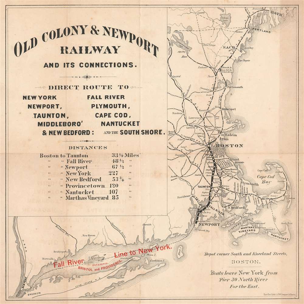
This is a c. 1867 New England Lithographic Company railroad map of Massachusetts, Rhode Island, and Maine highlighting the Old Colony and Newport Railroad. The map depicts the region from Bath, Maine, south to Martha's Vineyard and Nantucket and west to Brooklyn and New York City. A thick black line connects Boston and Newport and represents the Old Colony and Newport Railroads. Stops along the Old Colony and Newport are labeled, including Taunton and Fall River. Individual stops are also identified between Braintree and Cohasset, and Braintree and Plymouth. Other connecting railroads, including the Fitchburg Railroad, Cape Cod Railroad, and the Boston and Maine Railroad, appear as thinner black lines. Most have circles marking stops, but only a few are labeled. The Cape Cod Railroad is an exception because every stop marked along its route is also identified. Red overprinting along in the bottom left quadrant promotes the Old Colony's steamship line between Fall River and New York City. An excellent illustration of a steamer occupies part of Long Island Sound to emphasize the ease with which this trip could be made.
The Old Colony and Newport Railroad
The Old Colony and Newport Railroad existed from 1863 until 1872. It came into existence in July 1863 after the Old Colony and Fall River Railroad merged with the Newport and Fall River Railroad. The Old Colony and Newport finished the line between Fall River and Newport because bureaucratic nonsense from Massachusetts had barred the Newport and Fall River from building in Massachusetts. The Old Colony and Newport Railroad merged with the Cape Cod Railroad on May 1, 1872, and became the Old Colony Railroad on October 1.The Old Colony Railroad
Founded in 1845, the Old Colony Railroad operated in southeastern Massachusetts and parts of Rhode Island until 1893. Named after the 'Old Colony,' a reference to Plymouth, its network grew extensively through mergers and acquisitions. Old Colony operated both passenger and freight services, as well as steamship service to New York City. A steamer between Woods Hole, Martha's Vineyard, and Nantucket also operated from 1872. The New York, New Haven, and Hartford Railroad acquired the Old Colony trackage rights in 1893 and renamed it the 'Old Colony Division' of the New York, New Haven, and Hartford Railroad.Publication History and Census
This map was created and printed by the New England Lithographic Company and published by the Old Colony and Newport Railroad c. 1867. An example is part of the Sidney R. Knafel Map Collection at Philips Academy in Andover, Massachusetts. An OCLC reference exists for this map as well. However, it only references a digital map, which is likely the Philips Academy example that has been digitized by the Boston Public Library.Condition
Good. Exhibits some toning and offsetting. Verso repairs to fold separations and at fold intersections. Blank on verso.
References
OCLC 1037463808.