This item has been sold, but you can get on the Waitlist to be notified if another example becomes available, or purchase a digital scan.
1780 Schley Map of Europe, Africa and Asia during the Biblical Era
OldWorld-schley-1780$150.00

Title
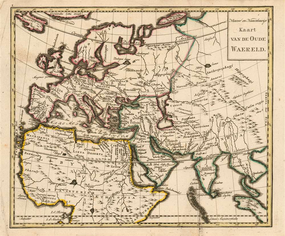
Nieuwe en naauwkeurige kaart van de Oude Waereld.
1780 (undated) 7.25 x 8.75 in (18.415 x 22.225 cm) 1 : 49674240
1780 (undated) 7.25 x 8.75 in (18.415 x 22.225 cm) 1 : 49674240
Description
This rare 1780 map of Europe, Northern Africa and Western Asia presents - with some notable exceptions - the parts of the world known to the Roman Empire during the Biblical period. Most of the place names are those which would have been familiar to Ptolemy, Pliny and Josephus. The geography shown is not ancient, however. Rather than being modeled after Ptolemy's mapping of the world known during the Roman era, the map reflects the geographical knowledge of the 18th century. Neither Nova Zemla nor Iceland, both shown here, were known to ancient geographers; and although distorted, both the Indian and Malay peninsulae are shown as they were understood after the discovery era. The mapmaker follows many of the early translators of Ptolemy in identifying the island of Taprobana as Sri Lanka. Similarly, Goa and Cambodia are marked and named on the map. Central Asia is labeled (libeled?) as the domain of cannibals and horse-eaters. The map was intended to accompany a book of Biblical geography, and to help the reader place the events of religious antiquity in the context of a modern, expanding world.
Publication History and Census
This map was engraved by Jacob van der Schley for Martinus de Bruyn's Bybelsche huis en zak-Atlas, an atlas of fifteen maps intended to accompany Johan Jacob Schmidt's 1776 Bybelsche Geögraphicus . The atlas was not produced until 1780 and was relegated to a small, solitary edition. Consequently all of the maps of the atlas are rare. OCLC shows only nine examples of the zak-Atlas in institutional collections. Only one example of this map appears in OCLC, catalogued as an anonymous work at Tilburg University.Cartographer
Jacob Van der Schley (1715 - 1779) was a prominent Amsterdam engraver and draftsman based out of Amsterdam. Schley apprenticed under portrait engraver Bernard Picart, whose style he imitated. He is said to have completed several of Picart's portraits following his master's death. While Schley is primarily known for his work as a portraitist and illustrator, he also has a considerable cartographic corpus. He is known to have worked with Bellin, Hondt, and Provost, among others. More by this mapmaker...
Source
De Bruyn, Martinus Bybelsche huis en zak-AtlasAmsterdam, 1780.
Condition
Very good condition; some marginal spotting, else excellent with original outline color.
References
OCLC 202465153.