This item has been sold, but you can get on the Waitlist to be notified if another example becomes available.
1962 Martin Bird's-Eye View Map of the Olympic Mountains and Puget Sound
OlympicPeaks-martin-1962$150.00

Title
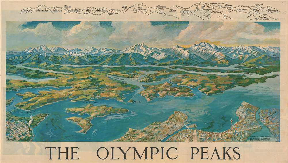
The Olympic Peaks.
1962 (dated) 20 x 35 in (50.8 x 88.9 cm)
1962 (dated) 20 x 35 in (50.8 x 88.9 cm)
Description
This is a 1962 George W. Martin bird's-eye view map of the Olympic Mountains and Puget Sound. The snowcapped Olympic Mountains, from Mt. Ellinor to Mt. Townsend, dominate the view. Puget Sound, its associated waterways, and lushly forested peninsulas and islands spread out toward the viewer from the foothills. Seattle (with the newly constructed Space Needle conspicuous among its buildings) and Tacoma occupy the foreground. Small towns, including Bremerton, Silverdale, Purdy, Allyn, and Kingston are all labeled in the expanse between Seattle-Tacoma and the Olympic Mountains. Bays, islands, inlets, and canals are also identified.
Publication History and Census
This map was created by George W. Martin and published in 1962 and published in 1962. Three examples are cataloged in OCLC and are part of the institutional collections at the University of Washington, the Washington State Library, and the Bibliothèque nationale de France.Cartographer
George Winston Martin (1901 - September 7, 1970) was an American educator, mountaineer, and artist. Martin held a master's degree in zoology from the University of Washington. He worked as an educator for thirty-six years, at Bremerton High School (where he eventually became vice principal) and as Registrar of Olympic College, a position he held for eighteen years. In 1948, Bob Thorson, Student Body President of Bremerton High School, fell to his death in the Olympic Mountains. This tragedy spurred Martin into pushing for improved mountaineering and wilderness education and safety. This drive helped Martin start the Outdoor Education Program at Olympic College, in which he taught corses in rescue and survival, advanced climbing, basic and advanced camp craft, and skiing. All these courses involved instruction in such diverse topics as botany, geology, climbing, camping and survival, astronomy, zoology, and meteorology. After Martin retired in 1966, he traveled the world: climbing mountains in Europe and hiking in the foothills of the Himalayas and visiting numerous countries, including Japan, India, and locations throughout Africa and the Middle East. Martin suffered a coronary episode on September 1, 1970, while presenting the Mountain Rescue Council oil 'By Nature's Rules'. While his recovery looked promising at one time, he succumbed a week later on September 7. More by this mapmaker...
Condition
Mounted on linen. Exhibits significant creasing, repaired tears, and some surface soiling. Priced accordingly.
References
Rumsey 8248.003. OCLC 41589356.