
1930 Bekins Map of Omaha, Nebraska

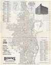
Map of Omaha Nebraska.
Moving to Omaha? Let Bekins help!
$150.00
Choose a Collection:
- Digital Map Information
- Suitable for large format printing
- Full resolution TIFF file
- ICC color profile embedded
- Delivered instantly via download link
This Item
Enquire
Moving to Omaha? Let Bekins help!
This is a 1930 Bekins Van and Storage Company city plan or map of Omaha, Nebraska. Depicting Omaha from the University of Nebraska-Omaha campus (then called Omaha University) to the Missouri River and from North Omaha south to Mandan Park. Streets are labeled throughout, along with numerous parks, athletic fields, hospitals, and schools. Both Union Pacific and Burlington railroad lines are illustrated and labeled, along with their respective depots. Both Carter Lake and the 'municipal aviation field' (now Eppley Airport) are labeled on the map's right side. Numerical street indexes appear in the upper-left and lower-right, and list streets north and south of Dodge Street, respectively.The Bekins Van and Storage Company
Bekins Van Lines, Inc. is a domestic and international moving company founded in Indianapolis, Indiana in 1891. Bekins is the oldest and largest household moving company in the United States and is one of the largest moving companies in North America. The company had a fleet of over 2,100 vehicles and operated over 300 locations as of 2009 and owned over four million square feet of warehouse space. Wheaton World Wide Moving acquired Bekins in 2012 and still operates Bekins Van Lines as a separate brand. Most similar Bekins maps illustrate California cities, this is the first we have seen of Omaha.Publication History
This map was created and published by the Bekins Van and Storage Company in 1930, was updated from an earlier edition published in 1924, and was printed in Omaha. Three examples are cataloged in OCLC and are part of the institutional collections at Pennsylvania State University, Ball State University, and the University of California, Santa Barbara.Condition
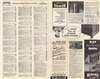
Very good. Closed margin tear professionally repaired on verso. Text and printed images on verso.
References
OCLC 47096571.