1849 R. H. Pease map of the Western Finger Lakes Region of New York State
OntarioCounty-pease-1849$200.00

Title
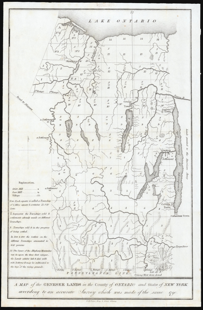
A Map of the Genesee Lands in the County of Ontario and State of New York according to an accurate Survey which was made of the same 1790.
1849 (undated) 13 x 8.25 in (33.02 x 20.955 cm) 1 : 460000
1849 (undated) 13 x 8.25 in (33.02 x 20.955 cm) 1 : 460000
Description
This is Richard H. Pease's 1849 map of part of Ontario County, New York, comprising part of the western Finger Lakes region known as Gorham and Phelps' Purchase. The map records the annexation of Iroquois lands after the American Revolution in response to their support of the British.
Historical Context
These lands had been alienated from the Iroquois following the American Revolutionary War (1775 - 1783), and title to sell the land had passed from Massachusetts in 1784 to land investors Oliver Phelps and Nathaniel Gorham in 1788. Later that year, Phelps and Gorham negotiated title to sell these lands from the Iroquois and had begun to do so when they were compelled in 1791 to sell all of the unsold land to Robert Morris, who would in turn sell at a massive profit in 1792 to the British 'the Pulteney Association.'Phelps and Gorham Purchase Surveys
Despite the title of the present work, there were two surveys of the Phelps and Gorham purchase: one made in 1788, and another re-survey in 1791 and 1792. The follow-up survey was executed to correct known flaws in the 1788 survey, particularly in its delineation of the easternmost boundary of the purchase: that so-called 'First Survey' had placed the boundary to the west of Seneca Lake and Geneva Town; the second survey of 1791-2 corrected the boundary to roughly bisect the Lake. The present map depicts the boundary according to the 1788 survey - which, in addition, appears to have missed Canadice Lake, between Hemlock and Honeoye Lakes (these are here but unnamed).A Closer Look
An array of settlements are marked on the map. On Seneca Lake, Geneva Town, Culver's Town, and Catherine's Town are marked. (The latter had been a Seneca village, named after a prominent Seneca woman, Catherine Montour. It was destroyed by Colonial Revolutionary forces in 1779, however - so its presence here is puzzling.) At the northeastern end of Crooked Lake is marked a Quaker settlement. This is at the site of present-day town of Milo. Ontario County's seat, Canandaigua, is marked 'County Town.' The whole of the surveyed land is divided into 'townships'. Some of these are marked as having been sold, and some of those are shown in the process of settlement.Publication History and Census
This map was printed in Albany in 1849 by Richard H. Pease, for inclusion in volume 2 of The Documentary History of the State of New-York. Only four examples of the separate map are listed in institutional collections, but the map appears on the market from time to time and the Documentary History is very well represented in institutional collections.Cartographer
Richard H. Pease (1813 - 1869) was an American merchant and lithographer active in Albany, New York, during the middle part of the 19th century. Pease is best recognized for his publication of America's first Christmas card for the 1849 -1850 holiday season. He also played a role in populating the American version of Santa Claus and tying it to consumerism in the holiday advertisements his produced for his 'Temple of Fancy or Pease's Great Variety Store.' Pease operated the Great Variety Store in tandem with his lithography business until he passed the store on to his son, Harry E. Pease, in 1855. The store was located at 516 Broadway, Albany. Pease also published hand-colored lithographs of fruit for Ebenezer Emmons’s book Agriculture of New York State, published between 1846 and 1854. From 1856 to 1867 he worked with the lithography firm of Hoffman, Knickerbocker and Co. More by this mapmaker...
Source
O'Callaghan, E. B., The Documentary History of the State of New-York arranged under direction of the Hon. Christopher Morgan, Secretary of State, (Albany: Weed, Parsons, and Co.) 1849.
Condition
Very good. Few marginal mends; mended split along one fold with no loss.
References
OCLC 81550203.