1944 Turner Map of East Asia and Central Pacific
OnToTokyo8th-turner-1944$425.00

Title
Dated Events. On to Tokyo. Invasion Map of the Pacific and the Far East. Eighth Edition. / War in Europe. Dated Events.
1944 (dated) 20 x 26 in (50.8 x 66.04 cm) 1 : 16500000
1944 (dated) 20 x 26 in (50.8 x 66.04 cm) 1 : 16500000
Description
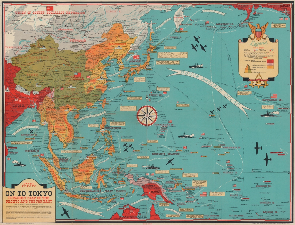
This is a Stanley Francis Turner map of the Pacific Theater of World War II (1939 - 1945), published in late October or early November 1944. As with Turner's other World War II maps, short text boxes highlight important events during the war up to publication, in this case from the Japanese attack on Pearl Harbor on December 7, 1941, until the U.S. invasion of the Philippines on October 17, 1944.
A Closer Look - World War II in the Pacific
Depicting from central India to Hawaii and from the Soviet Union and Alaska to northern Australia, Turner highlights Allied victories and Japanese expansion across the Pacific (including Corregidor, Bataan, and Guam). Text boxes inform on Japanese incursions into Manchuria, China, and French Indochina, as well as their alliance with the Axis. The Battle of Midway, Battle of the Coral Sea, and Battle of the Solomons are referenced by name. Red illustrates areas of under Allied control (India, Australia, and part of New Guinea). Pink, which colors the rest of New Guinea, part of New Britain, and most of the Solomon Islands, shades territory that has been retaken from the Japanese, and orange areas represent territory occupied by the Japanese.Verso Content: Dated Events War Map of Europe
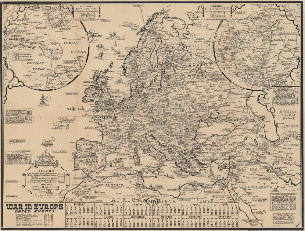
An edition of Turner's Dated Events War Map of Europe occupies the verso. This map is not as up to date as the recto map of the Pacific. Major events from 1944, including the D-Day landings, are not included, not to mention the complete lack of information concerning the 1943 invasion of Sicily. Intriguingly, other important events from 1943 do appear, including the Tehran Conference between Roosevelt, Churchill, and Stalin. The list of events on the Eastern Front (labeled 'The Great Russian Offensive') also includes events through the end of October 1943. Two polar inset maps occupy the upper corners.Publication History and Census
This map was created by Stanley Francis Turner and published by C. C. Peterson in 1944. We note a single example cataloged in OCLC: University of Minnesota Twin Cities, and another with the David Rumsey Map Collection.CartographerS
Stanley Francis Turner (1883 – 1953) was a visual artist and painter based in Toronto, Canada. Turner was born in Aylesbury, England. He studied art in London at the South Kensington School before migrating to Canada in 1903, where he studied at Ontario College of Art under George Reid and J. W. Beatty. Turner is best known as a painter and designer capable of working in a variety of mediums. During World War II, Turner took a contract with the Globe and Mail to illustrate pictorial maps of war events. Turner may have maintained the rights to his war maps, as he also seems to have had a contract with the advertiser and publisher, C.C. Peterson, also of Toronto, to publish and distribute his maps in the United States. Turner's maps are information dense and designed to illustrate the events of the war in an easily digestible pictorial format. Turner experimented with different ways of working with the cartographic ranging from simple Mercator projections to more contemporary equal-area projections. In 1930, Turner was elected an Associate of the Royal Canadian Academy of Arts. He died in Toronto in 1953. More by this mapmaker...
C. C. Peterson (fl. c. 1940 – 1950) was an advertising and publishing company based in Toronto Canada, but with distribution and licensing in both the United States and Canada. Peterson had contracts with the artist Stanley Francis Turner to publish pictorial 'war maps' during World War II. The company supplemented its income by selling advertisements on Turner's maps. Learn More...
Condition
Good. Wear along original fold lines. Verso repair to a fold separation. Pinholing in corners and along sides. Dated Events Map of Europe on verso.
References
Rumsey 10010.001. OCLC 613361665.