This item has been sold, but you can get on the Waitlist to be notified if another example becomes available, or purchase a digital scan.
1926 Plat Map of Opa-Locka, Florida
OpaLockaFlorida-unknown-1926$425.00

Title
Opa-Locka Florida.
1926 (undated) 22.25 x 35.25 in (56.515 x 89.535 cm) 1 : 3400
1926 (undated) 22.25 x 35.25 in (56.515 x 89.535 cm) 1 : 3400
Description
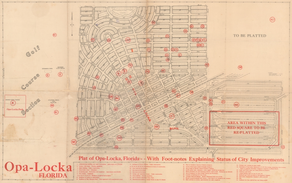
A one-of-a-kind planning plat map of Opa-Locka, Florida, a planned community spearheaded by aviation pioneer Glenn Curtiss, produced in tandem with the city's founding in 1926. It provides a fascinating look into the process of the city's development, including its highly distinctive 'Moorish Revival' architecture and nomenclature, based on the classic tales of the Arabian Nights.
The city's eventual layout did not entirely conform with what is projected here, demonstrating the early date of this plat. For example, at top, the 'ebony horse circle' and lake were replaced with additional housing on a simpler layout. Likewise, the area 'to be platted' at bottom-right did not quite pan out as envisioned here, and of course the top-right portion had not been planned at all at this point.
To spur growth, Curtiss relocated the Florida Aviation Camp to a parcel west of town - in the middle of a planned Golf Course. Nonetheless, just months after its founding, the city was devastated by the catastrophic 1926 Miami Hurricane, which slowed development. Opa-Locka recovered as a residential and industrial community, and during World War II (1939 - 1945), its airport was repurposed as a military base. Today, it serves the private jet community as the Miami-Opa Locka Executive Airport.
Flagler and other boosters of the region successfully promoted it as a paradisical escape from the grimy cities and cold weather of New England and the Mid-Atlantic. Land prices shot up at an astronomical rate and developers carved entirely new cities out of wetlands in mere months. In addition to Flagler's railway, the arrival of the highway system and associated businesses (gas stations, motels, restaurants, etc.) in the 1920s made the region more easily accessible. But the speculation around land prices in Florida had reached irrational heights, and the damage caused by two hurricanes followed by the financial crash of 1929 led to a collapse in the real estate market, ruining many investors in the process.
A Closer Look
Influenced by the 'garden city' school of urban planning, with architecture and street names drawn based on the Arabian Nights, this plat map displays the existing and planned lots of the city of Opa-Locka. Individual lots are numbered, with several shaded or circled, likely by a prospective investor or real estate agent. Red numbered circles, corresponding to an index at bottom, mark out important buildings in town, both extant and planned. These include a fire station, major businesses, a zoo, train station, and more. The Opa-Locka Company Administration Building (number 1 in the index) served as the city's first City Hall. After falling into disuse and disrepair, the building is currently undergoing renovations to reopen as a museum, part of a wider conservation boom in Opa-Locka. A small legend at right indicates the type of pavement on roads (oiled or rock) and the location of ornamental lights. The Seaboard Air Line railroad cuts diagonally straight through the town, reflecting the continued importance of passenger rail even as automobiles became more common.The city's eventual layout did not entirely conform with what is projected here, demonstrating the early date of this plat. For example, at top, the 'ebony horse circle' and lake were replaced with additional housing on a simpler layout. Likewise, the area 'to be platted' at bottom-right did not quite pan out as envisioned here, and of course the top-right portion had not been planned at all at this point.
Opa-Locka
Opa-Locka, Miami-Dade, Florida, was founded as 'Opa-tisha-woka-locka' in 1926 by aviation pioneer Glenn Curtiss (1878 - 1930). The unusual name is derived from an abbreviation of a Seminole phrase referring to the area's slightly higher elevation and, thus, drier ground than its surroundings. Curtiss, in conjunction with architect Bernhardt E. Muller, envisioned a unique city inspired by Moorish Revival architecture. The city was designed with themed streets, domes, minarets, and exotic street names like Ali Baba and Sultan Avenue. Curtiss's ambitious plans included nearly 100 Moorish-style buildings, many of which still stand, making Opa-Locka one of the most architecturally distinctive cities in the United States.To spur growth, Curtiss relocated the Florida Aviation Camp to a parcel west of town - in the middle of a planned Golf Course. Nonetheless, just months after its founding, the city was devastated by the catastrophic 1926 Miami Hurricane, which slowed development. Opa-Locka recovered as a residential and industrial community, and during World War II (1939 - 1945), its airport was repurposed as a military base. Today, it serves the private jet community as the Miami-Opa Locka Executive Airport.
Florida Land Boom(s)
In the late 19th and early 20th century, Florida experienced a series of land booms and crashes; the most well-known of these occurred in the 1920s. The collapse of a previous land boom that established Florida as a center for the citrus industry in the 1880s - 1890s allowed for the easy acquisition of large tracts of land at cut-rate prices. Industrialist and co-founder of Standard Oil Henry Flagler (1830 - 1913) seized the opportunity to build his Florida East Coast Railway and extend it to the region that would develop into Miami and other communities on the state's southeastern coast. Soon, competing modes of transport followed, including the Seaboard Air Line Railroad, which runs through the center of town here, additional railways, steamships, and automobile highways.Flagler and other boosters of the region successfully promoted it as a paradisical escape from the grimy cities and cold weather of New England and the Mid-Atlantic. Land prices shot up at an astronomical rate and developers carved entirely new cities out of wetlands in mere months. In addition to Flagler's railway, the arrival of the highway system and associated businesses (gas stations, motels, restaurants, etc.) in the 1920s made the region more easily accessible. But the speculation around land prices in Florida had reached irrational heights, and the damage caused by two hurricanes followed by the financial crash of 1929 led to a collapse in the real estate market, ruining many investors in the process.
Publication History and Census
This map is undated and contains no publication information, but was very likely produced by the Opa-Locka Company, Curtiss' outfit which existed both before and after the town's incorporation on May 14, 1926. From context, the map appears to predate the 1926 hurricane, which took place in mid-September, yielding a presumed date of early-mid 1926. We are unaware of any other examples of this map in institutional or private collections.Condition
Average. Map has been laid down on archival tissue to stabilize old fold splits. Slight loss reinstated along a few old lines. Light pencil annotations.