This item has been sold, but you can get on the Waitlist to be notified if another example becomes available, or purchase a digital scan.
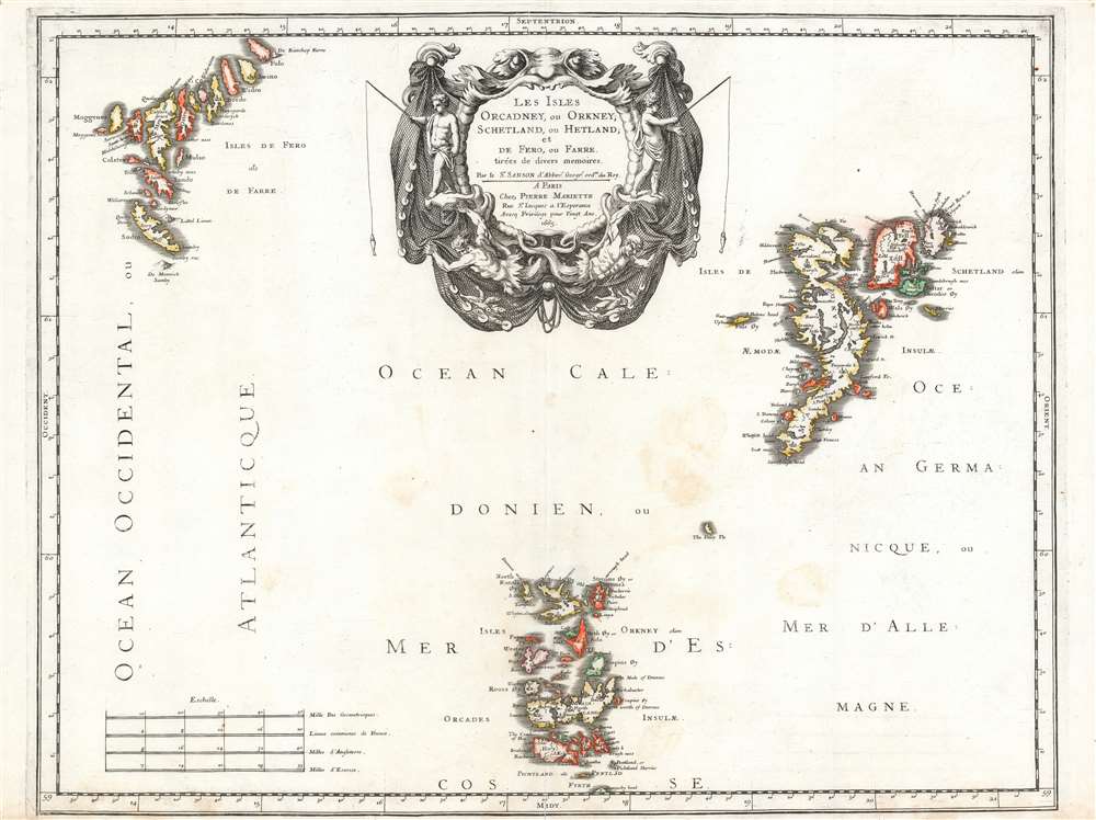
1665 Sanson Map of the Faroe, Shetland and Orkney Islands
Orcadney-sanson-1665$250.00

Title
Les Isles Orcadney, ou Orkney; Schetland, ou Hetland; et de Fero, ou Farre, tirées de divers memoires.
1665 (dated) 17 x 21.5 in (43.18 x 54.61 cm) 1 : 1846560
1665 (dated) 17 x 21.5 in (43.18 x 54.61 cm) 1 : 1846560
Description
This is a scarce, beautifully engraved 1655 map of the Orkney, Shetland and Faroe Islands, produced by Nicolas Sanson, the preeminent French mapmaker of the 17th century. While the detail of the Orkneys and the Shetlands derives from contemporaneous Dutch sources, Sanson's map is the first to focus on the Faroe Islands, and place them in reasonably accurate context with the other two archipelagos.
A Superb Cartouche
Sanson's maps, more often than not, leaned towards the spartan. This is not the case here, the cartouche resembles the mouth of a great sea monster and is curtained with a fishing net - doubtless a reference to rich whaling grounds. Below, two mermen struggle with the folds of the net. Flanking the cartouche are boys with fishing poles, plainly disappointed with the wee fish dangling at the ends of their lines.Publication History and Census
The map was printed in 1655 for Nicolas Sanson's folio atlas by the firm of Pierre Mariette, with whom the geographer had a long and profitable partnership. Other examples appeared in the 18th century under other imprints - such as Jean Fortin - but this map is scarce in its Sanson-Mariette editions, being cataloged in only four institutional collections.CartographerS
Nicolas Sanson (December 20, 1600 - July 7, 1667) and his descendants were the most influential French cartographers of the 17th century and laid the groundwork for the Golden Age of French Cartography. Sanson was born in Picardy, but his family was of Scottish Descent. He studied with the Jesuit Fathers at Amiens. Sanson started his career as a historian where, it is said, he turned to cartography as a way to illustrate his historical studies. In the course of his research some of his fine maps came to the attention of King Louis XIII who, admiring the quality of his work, appointed Sanson Geographe Ordinaire du Roi. Sanson's duties in this coveted position included advising the king on matters of geography and compiling the royal cartographic archive. In 1644, he partnered with Pierre Mariette, an established print dealer and engraver, whose business savvy and ready capital enabled Sanson to publish an enormous quantity of maps. Sanson's corpus of some three hundred maps initiated the golden age of French mapmaking and he is considered the 'Father of French Cartography.' His work is distinguished as being the first of the 'Positivist Cartographers,' a primarily French school of cartography that valued scientific observation over historical cartographic conventions. The practice result of the is less embellishment of geographical imagery, as was common in the Dutch Golden Age maps of the 16th century, in favor of conventionalized cartographic representational modes. Sanson is most admired for his construction of the magnificent atlas Cartes Generales de Toutes les Parties du Monde. Sanson's maps of North America, Amerique Septentrionale (1650), Le Nouveau Mexique et La Floride (1656), and La Canada ou Nouvelle France (1656) are exceptionally notable for their important contributions to the cartographic perceptions of the New World. Both maps utilize the discoveries of important French missionaries and are among the first published maps to show the Great Lakes in recognizable form. Sanson was also an active proponent of the insular California theory, wherein it was speculated that California was an island rather than a peninsula. After his death, Sanson's maps were frequently republished, without updates, by his sons, Guillaume (1633 - 1703) and Adrien Sanson (1639 - 1718). Even so, Sanson's true cartographic legacy as a 'positivist geographer' was carried on by others, including Alexis-Hubert Jaillot, Guillaume De L'Isle, Gilles Robert de Vaugondy, and Pierre Duval. More by this mapmaker...
Pierre Mariette (1569 - 1657) was a French publisher and engraver active in Paris during the first half of the 19th century. Mariette established himself as successful publisher of art prints, but decided to turn his energy to cartography with the purchase of the plates for Melchior Tavernier's maps in 1644. Tavernier had partnered with Sanson before his death and Mariette followed suit. Around 1644- 1648 Mariette partnered with Nicolas Sanson, a then nascent figure in French cartography, to produce folio maps and atlases. The Sanson-Mariette relationship depended upon Sanson to draw and obtain rights for the maps while Mariette engraved them and paid for the expensive printing process. The two then shared rights to the maps into perpetuity. The finished copper plates were split between two such that neither could publish an atlas without the other's assent. The relationship seemed reasonably amicable until Mariette's death in 1657, when disputes arose between Sanson and Mariette's heirs. A court battle finally returned the most of the plates to Sanson's own heirs in 1674. As a consequence, some printings feature the Mariette imprint, others the Sanson imprint, and still others both imprints. Learn More...
Source
Sanson, N. and Mariette, P., Atlas du Monde, (Paris) 1665.
Condition
Very good. Top and bottom trimmed close but borders complete. Bright, attractive original outline color.
References
OCLC 431254790.