
Mariette, Pierre

Pierre Mariette (1569 - 1657) was a French publisher and engraver active in Paris during the first half of the 19th century. Mariette established himself as successful publisher of art prints, but decided to turn his energy to cartography with the purchase of the plates for Melchior Tavernier's maps in 1644. Tavernier had partnered with Sanson before his death and Mariette followed suit. Around 1644- 1648 Mariette partnered with Nicolas Sanson, a then nascent figure in French cartography, to produce folio maps and atlases. The Sanson-Mariette relationship depended upon Sanson to draw and obtain rights for the maps while Mariette engraved them and paid for the expensive printing process. The two then shared rights to the maps into perpetuity. The finished copper plates were split between two such that neither could publish an atlas without the other's assent. The relationship seemed reasonably amicable until Mariette's death in 1657, when disputes arose between Sanson and Mariette's heirs. A court battle finally returned the most of the plates to Sanson's own heirs in 1674. As a consequence, some printings feature the Mariette imprint, others the Sanson imprint, and still others both imprints.
Rare, French-printed Edition.
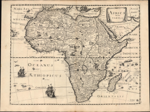
Africae nova Tabula.
$3,000.00
Acquire
- Digital Map Information
- Suitable for large format printing
- File Size: 18.78 MB
- File Type: ZIP / TIFF
- ICC color profile embedded
- Delivered instantly via download link
This is Peter Mariette's 1650 map of Africa, published in his Theatre Géographique de France. The present example is a rare French edition that does not appear in OCLC and has appeared only twice on the market since 2008. (more details)
First specific map of Vietnam.
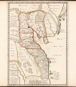
Carte du Royaume d'Annam, comprenant les Royaumes du Tumkin et de la Cocinchine.
$9,500.00
Acquire
- Digital Map Information
- Suitable for large format printing
- DPI: 600
- File Size: 12.7 MB
- File Type: ZIP / TIFF
- ICC color profile embedded
- Delivered instantly via download link
This is the Alexander de Rhodes and Pierre Mariette 1653 map of Vietnam, considered the first specific map of the Kingdom of Annam, or Tonkin, today's North Vietnam. This map represents a major milestone in the mapping of Vietnam and would prove the underpinning cartography of this region through the mid-19th century. (more details)