This item has been sold, but you can get on the Waitlist to be notified if another example becomes available, or purchase a digital scan.
1863 Public Survey Map of Oregon
Oregon-publicsurvey-1863$125.00

Title
A Diagram of Public Surveys in Oregon.
1863 (dated) 18.5 x 24.5 in (46.99 x 62.23 cm) 1 : 1140480
1863 (dated) 18.5 x 24.5 in (46.99 x 62.23 cm) 1 : 1140480
Description
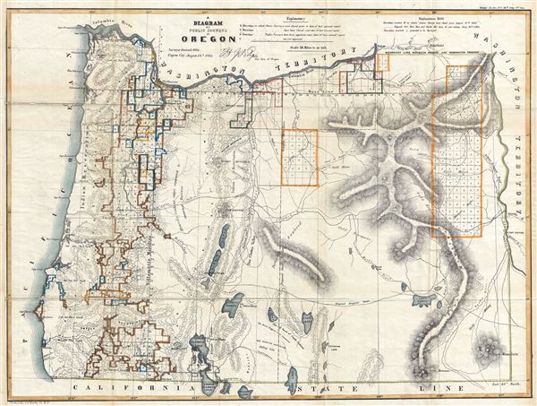
This is a fine 1863 public survey map of Oregon. It covers the region from the Pacific Ocean to Boise and from the Columbia River to the California state boundary. The map was prepared to illustrate the progress of the land survey work in Oregon, noted via a series of blocks representing the survey grid. An explanation along the top border describes the various markings in the blocks. The map notes several important towns, cities, mountain ranges, including the Cascades and the Blue Mountains, with relief shown by hachures. It also identifies Indian reservations and villages, as well as several trails, including the Applegate Trail, the Proposed Emigrant Trail, Trail to Powder River and Fremont's Trail, among others. Forts, lakes, rivers and other topographical features are noted throughout. The cartographer also identifies gold discoveries in the Blue Mountains near Auburn, Canyon City, and Round Lake. Wheat has this to say:
eastern Oregon is much enlivened by gold discoveries. 'Gold Mines' appears near the heads of the John Days River (east of the new Canyon City); 'Gold Prospects' near the southern headwaters of the Crooked River, 'Gold Mining' down the Owyhee River; 'Gold Mining' at the head of the Malheur River; and 'Gold Mines' adjacent to the Burnt River and the upper Power - where Auburn has now appeared. The term 'Mormon Basin' has been given to a broad area north of the Malheur. In th Grande Ronde Valley 'Gold Mines' appears again. On the Umatilla River is shown, without a name, 'County Seat of Baker County.' Curiously although this map was signed as late as August 24, 1863, no Idaho is recognized.' 'Washington Territory lies east as well as North of the State Boundaries.This map was engraved by J. Bien and prepared by B. J. Pengra, Surveyor General of Oregon and issued in the 1864 congressional report, Message of the President of the United States to the Two Houses of Congress at the Commencement of the First Session of the Thirty-Eighth Congress.
CartographerS
The General Land Office (1812 - 1946) was an independent agency charged with the administration and sale of public lands of the western territories of the United States under the Preemption Act of 1841 and the Homestead Act of 1862. During a time of frenetic energy and rapid westward expansion, the Land Office oversaw the surveying, platting, mapping and eventually the sale of much of the Western United States and Florida. The structural layout of the western United States that we see today, and many of their district and county divisions, are direct result of the early surveying work of the General Land Office. More importantly, as a branch of the Federal Government in Washington D.C. and the only agency able to legally sell and administer public lands in the western territories of the United States, the General Land Office played a pivotal role in consolidating power away from the original states and into the hands of the centralized federal government. The General Land Office was absorbed into the Department of Interior in 1849 and in 1946 merged with the United States Grazing Service to become the Bureau of Land Management. Today the Bureau of Land Management administers the roughly 246 million acres of public land remaining under federal ownership. More by this mapmaker...
Julius (Julien) Bien (September 27, 1826 - December 21, 1909) was a German-Jewish lithographer and engraver based in New York City. Bien was born in Naumburg, Germany. He was educated at the Academy of Fine Arts, Cassell and at Städel's Institute, Frankfurt-am-Main. Following the suppression of the anti-autocratic German Revolutions of 1848, Bien, who participated in the pan-German movement, found himself out of favor in his home country and joined the mass German immigration to the United States. Bien can be found in New York as early as 1849. He established the New York Lithographing, Engraving & Printing Company in New York that focused on the emergent chromo-lithograph process - a method of printing color using lithographic plates. His work drew the attention of the U.S. Government Printing Office which contracted him to produce countless government maps and surveys, including the Pacific Railroad Surveys, the census, numerous coast surveys, and various maps relating to the American Civil War. Bien also issued several atlases both privately and in conjunction with a relation, Joseph Bien. At the height of his career Bien was elected president of the American Lithographers Association. After his death in 1909, Bien's firm was taken over by his son who promptly ran it into insolvency. The firm was sold to Sheldon Franklin, who, as part of the deal, retained the right to publish under the Julius Bien imprint. In addition to his work as a printer, Bien was active in the New York German Jewish community. He was director of the New York Hebrew Technical Institute, the New York Hebrew Orphan Asylum, and president of the B'nai B'rith Order. Learn More...
Source
Government Printing Office, Message of the President of the United States to the Two Houses of Congress at the Commencement of the First Session of the Thirty-Eighth Congress, (Washington) 1864.
Condition
Very good. Some wear and toning along original fold lines. Professionally flattened and backed with archival tissue.
References
Rumsey 1077.007. Wheat, Carl Irving, Mapping of the Transmississippi West, 1540-1861, 1088.