This item has been sold, but you can get on the Waitlist to be notified if another example becomes available, or purchase a digital scan.
1827 Map of The Oregon Territory (Idaho, Western Montana, Wyoming)
OregonTerritory-vandermaelen-1827$425.00

Title
Amer. Sep. Partie des Etats-Unis No. 39.
1827 (undated) 18.75 x 21 in (47.625 x 53.34 cm) 1 : 1641836
1827 (undated) 18.75 x 21 in (47.625 x 53.34 cm) 1 : 1641836
Description
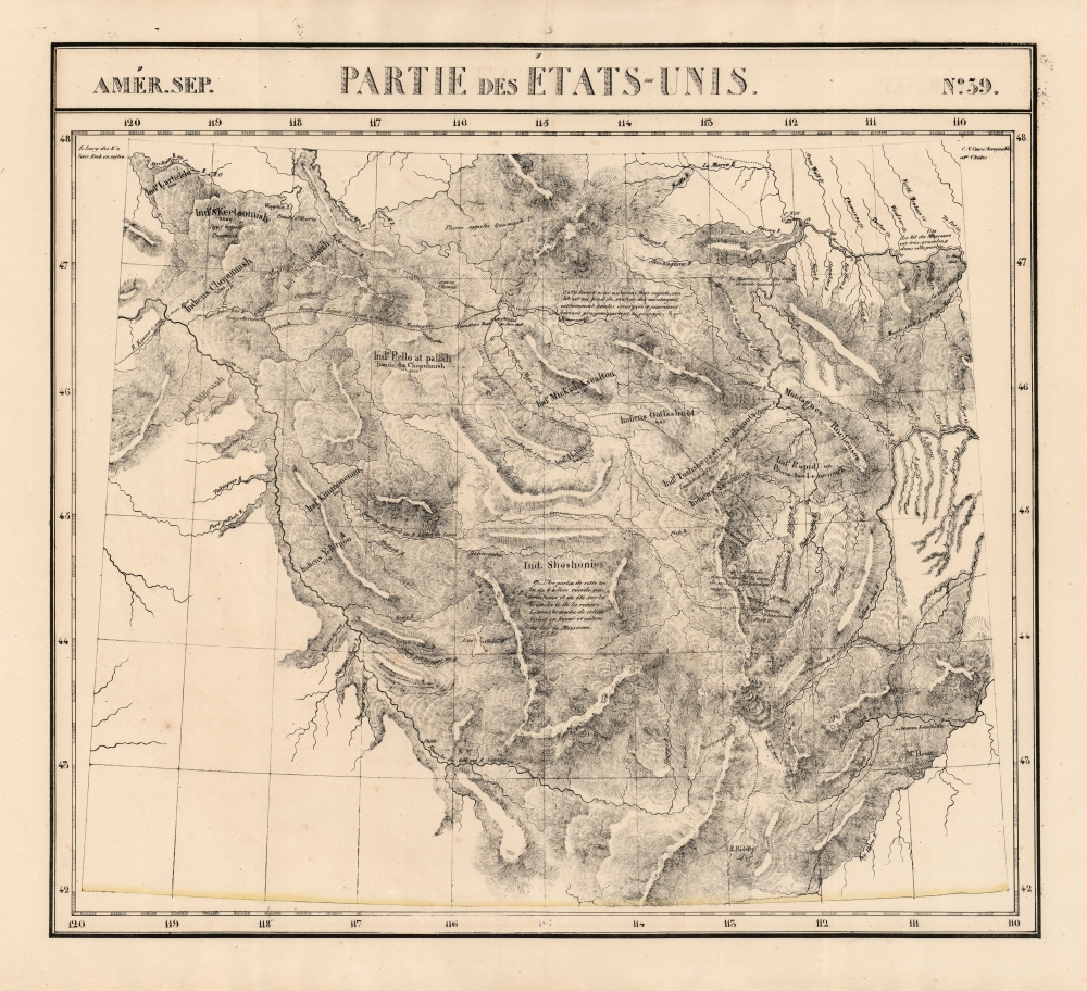
This is Philipe Vandermaelen's revised 1827 map of the eastern Oregon Territory, capturing the mountainous region between the upper Missouri River and the headwaters of the Columbia River, which is now Idaho and the western parts of Montana and Wyoming. It was the largest-scale map of this region produced to date - 'no mapmaker had previously attempted to use such a large scale for any western American area.' (Wheat). Like all of the maps from Vandermaelen's Atlas, it is the also the first map of the region executed in lithograph.
In common with Vandermaelen's other maps of the west, he includes here regions of Native habitation, naming the specific nations and indicating their estimated populations; particularly prominent here are the Shoshone.
A Closer Look
This is the second iteration of this map: Vandermaelen's first, printed in 1825 and entitled 'Partie de l'Oregon' covered the same area, but with a radically different interpretation of the location and character of the region's mountains, and lacking the explorers' tracks so important to placing this work in its historical context: the 1804-6 tracks of Lewis and Clark, and the 1807-8 tracks of John Colter (the first European explorer to enter the Yellowstone region).On the Map
The map focuses on the mountains lying between the Snake River (here termed Lewis' River) and the upper Missouri River; it spans from the Flathead River in the north to Lake Riddle and Lake Eustis, the latter name being the one used for Yellowstone Lake on William Clark's map of the region, from which the rivers, passes and explorers' tracks on this map are mainly drawn. The mountains - indicated with hachure - resemble neither those on the Lewis and Clark nor those on the 1825 first edition of Vandermaelen's own map. It is probable that in revising his earlier map to incorporate the explorers' tracks, Vandermaelen saw that the pictorial rendition of the Rocky Mountains and the Tetons on the earlier maps appeared to nonsensically contradict the courses of the rivers and the paths chosen by the explorers. The resulting delineation of the regions mountains is no less imaginary than those of the precursor maps, but here at least the courses of rivers do not pass magically through ridges.In common with Vandermaelen's other maps of the west, he includes here regions of Native habitation, naming the specific nations and indicating their estimated populations; particularly prominent here are the Shoshone.
Publication History
This map appeared in the fourth part, 'Quatrième partie, Amér. sept.' of Vandermaelen's Atlas universel de géographie physique, politique, statistique et minéralogique. The atlas was produced in one edition in 1827; only 810 complete sets were sold. The full set of six volumes appears in eleven institutional collections in OCLC; the 4th volume alone is listed in 9. This map is listed as a separate only six times in OCLC, although it has appeared on the market from time to time.Cartographer
Philippe Marie Guillaume Vandermaelen (December 23, 1795 - May 29, 1869) was a Flemish cartographer active in Brussels during the first part of the 19th century. Vandermaelen is created with "one of the most remarkable developments of private enterprise in cartography," namely his remarkable six volume Atlas Universel de Geographie. Vandermaelen was born in Brussels in 1795 and trained as a globe maker. It was no doubt his training as a globe maker that led him see the need for an atlas rendered on a universal scale in order that all bodies could be understood in relation to one another. In addition to his great work Vandermaelen also produced a number of globes, lesser maps, a highly detailed 250 sheet map of Belgium, and several regional atlases. More by this mapmaker...
Source
Vandeermaelen, P., Atlas universel de geographie physique, politique, statistique et mineralogique, (Bruxelles: Vandermaelen) 1827.
Atlas Universel de Geographie. This great work, featuring some 378 unique maps and compiled over three years, was the first lithograph atlas, and the first to render the world on the same projection and at a uniform scale. It was no doubt Vandermaelen’s training a globe maker that led him see the need for an atlas rendered uniformly so that all bodies could be understood in relation to one another. As a result, many newly emerging areas received more attention than prior efforts. Maps of the American West, in particular, benefited: ‘no mapmaker had previously attempted to use such a large scale for any western American area.’ (Wheat). Central and South Asia also appear in sharper focus. Despite Vandermaelen’s reliance upon existing sources, his maps very frequently provided the clearest depictions available of many poorly-understood parts of the world. The atlas was an expensive production, costing $800 in 1827. Subscription lists indicate that only 810 full sets of the atlas were sold. It was printed on high-quality paper with superior hand coloring and was engraved in a clear, legible style. Conjoined, the maps of Vendermaelen's atlas would create a massive globe some 7.75 meters in diameter, a feat which was accomplished at the Etablissement Geographique de Brussels.
Condition
Very good. Mend to upper centerfold outside printed image, else excellent.
References
Rumsey 2212.244. OCLC 741635731. Wheat, C. I., Mapping of the Transmississippi West, 1540 – 1861, #378. Phillips Atlases #749.