This item has been sold, but you can get on the Waitlist to be notified if another example becomes available, or purchase a digital scan.
1861 Mitchell Map of Washington, Oregon, Idaho, and Montana
OregonWashington-mitchell-1861$87.50

Title
Map of Oregon, Washington, and Part of British Columbia.
1860 (dated) 11.25 x 13.75 in (28.575 x 34.925 cm) 1 : 4000000
1860 (dated) 11.25 x 13.75 in (28.575 x 34.925 cm) 1 : 4000000
Description
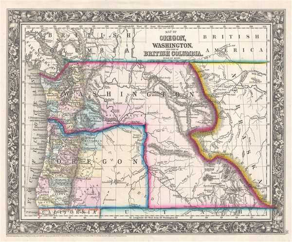
This is an 1861 Samuel Augustus Mitchell, Jr. map of the Washington Territory and Oregon. The map depicts the region from the Pacific Ocean to the Nebraska Territory and from Canada to California and the Utah Territory. Here, the Washington Territory is illustrated in its most expansive state, stretching from the Pacific Ocean to modern-day Montana and Wyoming, with the eastern border lying on the Continental Divide. This border configuration would last from 1859, when Oregon became a state and adopted its modern-day borders, and 1861, when the southeastern corner of the Washington Territory was ceded to Nebraska. The rest of the Washington Territory would be ceded to the Idaho Territory in 1863.
Three important transportation routes in the history of the western United States are illustrated here. The first is the Oregon Trail, which, though not shown in its entirety, played a critical role in the settlement of the West. Fort Bonneville, Fort Hall, Fort Boise, and other waypoints along the trail are labeled, and the trail is illustrated from South Pass (located in the bottom right corner of the map) to Walla Walla, Washington. It is labeled as the 'Emigrant Route from the States'. Also illustrated beginning at South Pass, the California Trail snakes its way along the bottom border. Labeled as the 'Emigrant Waggon Road to California', between 1848 and 1869 over a quarter of a million people traveled along the route not only to California, but along spur trails to myriad other locations in the West.
The third transportation route illustrated here is the route Governor Isaac Stevens proposed for the transcontinental railroad. Although only the western portion of the proposed route is illustrated, but not labeled, this important rail route surveyed by Stevens eventually became the route of the Northern Pacific Railroad. Starting from St. Paul, Minnesota, Stevens surveyed and proposed a route that roughly following the 47th and 49th parallels westward and terminated at Puget Sound. He boasted that the harsh winter conditions of the northern territories would 'not present the slightest impediment to the passage of railroad trains.' To this the expedition's naturalist George Stuckley responded, 'A road might be built over the tops of the Himalayan mountains – but no reasonable man would undertake it.' Though the Stevens route appears on many early maps, it was not seriously entertained by any rational party other than Stevens himself. Following Stevens' death in 1862 during the Civil War Battle of Chantilly, the campaign for a far northern route lost its only champion and consequently its momentum. Nonetheless, the northern Pacific route was eventually completed, and Ulysses S. Grant drove the 'Golden Spike' in western Montana on Septemer 8, 1883.
Numerous details are included in the western portion of both the Washington Territory and Oregon. Individual counties are illustrated, labeled, and shaded different colors to allow for easy differentiation. Numerous towns and villages are labeled, including Olympia, Seattle, and Portland. Rivers snake their way throughout most of the map, while the Ricky Mountains cut a distinctive line down the eastern quarter of the map, creating the Washington Territory's eastern border. The whole is surrounded by the attractive floral border common to Mitchell atlases between 1860 and 1865.
This map was prepared by S. A. Mitchell Jr. for inclusion in the 1861 edition of Mitchell's New General Atlas. Like many American map publishers of this period, Mitchell did not regularly update his copyrights, consequently this map is dated and copyrighted to 1860: 'Entered according to Act of Congress in the Year 1860 by S. Augustus Mitchell Jr. in the Clerk's Office of the District Court of the U.S. for the Eastern District of Pennsylvania.'
Cartographer
Samuel Augustus Mitchell (March 20, 1792 - December 20, 1868) began his map publishing career in the early 1830s. Mitchell was born in Bristol, Connecticut. He relocated to Philadelphia in 1821. Having worked as a school teacher and a geographical writer, Mitchell was frustrated with the low quality and inaccuracy of school texts of the period. His first maps were an attempt to rectify this problem. In the next 20 years Mitchell would become the most prominent American map publisher of the mid-19th century. Mitchell worked with prominent engravers J. H. Young, H. S. Tanner, and H. N. Burroughs before attaining the full copyright on his maps in 1847. In 1849 Mitchell either partnered with or sold his plates to Thomas, Cowperthwait and Company who continued to publish the Mitchell's Universal Atlas. By about 1856 most of the Mitchell plates and copyrights were acquired by Charles Desilver who continued to publish the maps, many with modified borders and color schemes, until Mitchell's son, Samuel Augustus Mitchell Junior, entered the picture. In 1859, S.A. Mitchell Jr. purchased most of the plates back from Desilver and introduced his own floral motif border. From 1860 on, he published his own editions of the New General Atlas. The younger Mitchell became as prominent as his father, publishing maps and atlases until 1887, when most of the copyrights were again sold and the Mitchell firm closed its doors for the final time. More by this mapmaker...
Source
Mitchell, S. A., Mitchell's New General Atlas Containing Maps of the Various Countries of the World, Plans of Cities, Etc., embraced in Forty-Seven Quarto Maps, Forming a series of Seventy-Six Maps and Plans, together with Valuable Statistical Tables (Philadelphia: S. Augustus Mitchell, Jr.) 1861.
Mitchell's New General Atlas was published by Samuel Augustus Mitchell, Jr., the son of the prolific cartographer Samuel Augustus Mitchell. Many of the plates are derived from the his father's Mitchell's Universal Atlas, but not directly. The Mitchell's Universal Atlas was initially sold to Thomas, Cowperthwait, and Company in 1849, and again to Charles Deliver in 1856. It was Deliver who introduced the new vibrant color scheme, abandoning the older Mitchell's Universal Atlas green borders and themes for bright reds, blues, and yellows. Samuel Augustus Mitchell, Jr. acquired the Deliver plates in 1859. He added his own floral motif border, but doubled down on the vibrant color scheme, thus introducing to the American public the most vividly colored American atlas of the 19th century. In 1860, he published the first edition of his New General Atlas and, despite a slump in sales during the American Civil War, attained a level of success to rival his father. Mitchell would continue to publish the New General Atlas until 1887, when the firm formally closed.
Condition
Very good. Even overall toning. Blank on verso.
References
Rumsey 0565.026 (1860 edition).