
This item below is out of stock, but another example (left) is available. To view the available item, click "Details."
Details
1862 Mitchell Map of the Pacific Northwest: Washington, Oregon, Idaho
1862 (dated) $200.00
1863 Mitchell Map of the Pacific Northwest: Washington, Oregon, Idaho
OregonWashingtonIdaho-mitchell-1863$100.00

Title
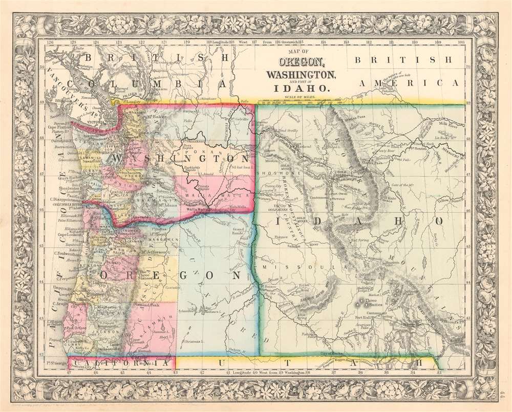
Map of Oregon, Washington, and Part of Idaho.
1860 (dated) 11.5 x 14 in (29.21 x 35.56 cm) 1 : 4400000
1860 (dated) 11.5 x 14 in (29.21 x 35.56 cm) 1 : 4400000
Description
This is an 1863 Samuel Augustus Mitchell, Jr. map of the Pacific Northwest in one of its most ephemeral configurations. Depicting the region from the Pacific Ocean to South Pass and from Canada to California and Utah, this map illustrates part of the newly-formed Idaho Territory when it was at its largest. The Oregon Trail winds its way from South Pass northwest roughly along the Snake River to Walla Walla, Washington. Cities, towns, and other settlements are labeled throughout the region, including Olympia and Seattle, Washington, Salem, Oregon, and Lewiston, Idaho (then the territorial capital). Fort Boise is identified as well and would become the territorial capital three years after this map was published by a one-vote margin.
Counties are labeled and shaded various colors in Washington and Oregon, with the western third of Oregon labeled simply as 'unexplored'. No county divisions are illustrated in Idaho, but the Missouri and Yellowstone Rivers are labeled, as are numerous smaller rivers. The Rocky Mountains cut diagonally through Idaho and the territory west of the mountains is labeled simply as 'broken mountainous country'.
Counties are labeled and shaded various colors in Washington and Oregon, with the western third of Oregon labeled simply as 'unexplored'. No county divisions are illustrated in Idaho, but the Missouri and Yellowstone Rivers are labeled, as are numerous smaller rivers. The Rocky Mountains cut diagonally through Idaho and the territory west of the mountains is labeled simply as 'broken mountainous country'.
Idaho Territory
The Idaho Territory was created by an Act of Congress on March 3, 1863. At its largest (part of which is depicted here) the Territory stretched from the Continental Divide to the borders of Washington and Oregon, encompassing all of modern-day Idaho and Montana, and nearly all of modern-day Wyoming. Its northern border was the newly-agreed upon 49th parallel between the United States and Canada (then a British possession) and the northern border of Utah. This configuration of the Idaho Territory lasted for only a year because the Montana Territory was formed in 1864 and further land was ceded to the Dakota Territory that year as well. The Idaho Territory lost yet more land when the Wyoming Territory was formed in 1868. Idaho would not receive statehood until 1890.Publication History
This map was created and published by Samuel Augustus Mitchell in the 1863 edition of his New General Atlas. It is one of the scarcer maps Mitchell produced due to the ephemeral nature of the geography and that it was only published in the 1863 edition of his atlas.Cartographer
Samuel Augustus Mitchell (March 20, 1792 - December 20, 1868) began his map publishing career in the early 1830s. Mitchell was born in Bristol, Connecticut. He relocated to Philadelphia in 1821. Having worked as a school teacher and a geographical writer, Mitchell was frustrated with the low quality and inaccuracy of school texts of the period. His first maps were an attempt to rectify this problem. In the next 20 years Mitchell would become the most prominent American map publisher of the mid-19th century. Mitchell worked with prominent engravers J. H. Young, H. S. Tanner, and H. N. Burroughs before attaining the full copyright on his maps in 1847. In 1849 Mitchell either partnered with or sold his plates to Thomas, Cowperthwait and Company who continued to publish the Mitchell's Universal Atlas. By about 1856 most of the Mitchell plates and copyrights were acquired by Charles Desilver who continued to publish the maps, many with modified borders and color schemes, until Mitchell's son, Samuel Augustus Mitchell Junior, entered the picture. In 1859, S.A. Mitchell Jr. purchased most of the plates back from Desilver and introduced his own floral motif border. From 1860 on, he published his own editions of the New General Atlas. The younger Mitchell became as prominent as his father, publishing maps and atlases until 1887, when most of the copyrights were again sold and the Mitchell firm closed its doors for the final time. More by this mapmaker...
Source
Mitchell Jr., S. A., Mitchell's New General Atlas, containing Maps of the Various Countries of the World, Plans of Cities, Etc., Embraced in Fifty-five Quarto Maps, forming a series of Eighty-Seven Maps and Plans, together with Valuable Statistical Tables. 1863 Edition.
Mitchell's New General Atlas was published by Samuel Augustus Mitchell, Jr., the son of the prolific cartographer Samuel Augustus Mitchell. Many of the plates are derived from the his father's Mitchell's Universal Atlas, but not directly. The Mitchell's Universal Atlas was initially sold to Thomas, Cowperthwait, and Company in 1849, and again to Charles Deliver in 1856. It was Deliver who introduced the new vibrant color scheme, abandoning the older Mitchell's Universal Atlas green borders and themes for bright reds, blues, and yellows. Samuel Augustus Mitchell, Jr. acquired the Deliver plates in 1859. He added his own floral motif border, but doubled down on the vibrant color scheme, thus introducing to the American public the most vividly colored American atlas of the 19th century. In 1860, he published the first edition of his New General Atlas and, despite a slump in sales during the American Civil War, attained a level of success to rival his father. Mitchell would continue to publish the New General Atlas until 1887, when the firm formally closed.
Condition
Very good. Even overall toning. Blank on verso.