This item has been sold, but you can get on the Waitlist to be notified if another example becomes available, or purchase a digital scan.
1847 Phelps Ornamental Propaganda Map of the Untied States (Manifest Destiny)
OrnamentalMapUnitedStates-phelps-1847$1,250.00

Title
Ornamental Map of The United States and Mexico, 1847.
1847 (dated) 28.5 x 21 in (72.39 x 53.34 cm) 1 : 12000000
1847 (dated) 28.5 x 21 in (72.39 x 53.34 cm) 1 : 12000000
Description
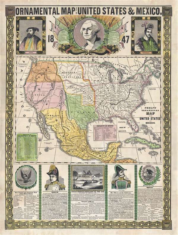
A remarkably graphic propaganda map of the United States in 1847 by Humphrey Phelps. Boldly expressing U.S. dominance of the continent, this map loudly proclaims Manifest Destiny. The United States is here transformed by victory in the Mexican-American War and the acquisition of Texas and Upper California. Both areas are illustrated at their fullest extent, with California extending form the Pacific to the Rio Grande and Texas extending from the Rio Grande to the Sabine River and as far north as the Arkansas river. A potential route for a railroad runs from New York, to Buffalo, to Chicago, then west along the Oregon Trail to Oregon City, anticipating the construction of the transcontinental railroad by nearly 20 years.
The map's most arresting feature is its dramatic decorative surround. At the top George Washington appears in mythic form, haloed by an imperial olive wreath, radiating rays of light, and surrounded by flags. To his left and right are Hernan Cortez and Montezuma, representing, respectively, European expansion into America and indigenous American Indian civilization, a theme of contrast that will be repeated elsewhere on the map.
Below the map proper there are four sections, arranged left to right. The leftmost is a chronological history of the United States from the settlement of Jamestown in 1606 to the 1846 U.S. victory in Mexican-American War.
The second section, below an illustration of General Zachary Taylor (later president), praises the glory of the Oregon climate and richness of the land. It impresses U.S. claims to the region dating from the establishment of John Jacob Astor's fur trading depot, Astoria, on the Columbia River in 1811. The text goes on to describe the imminent construction of a transcontinental railroad and how that railroad will shorten transit time across the continent to just 8 days. It further expresses the hope that such a railroad, combined with a lively Pacific naval traffic, would allow American merchants to dominate trade between China and Europe.
The third segment illustrates the great Aztec Temple of the Sun in Tenochtitlan, which, when this map was printed, had been replaced by the cathedral and plaza mayor of Mexico City. Below this there is a chronology of the Conquest of the Aztec Empire under Cortez from 1519 to 1521.
Under a portrait of Mexican General Antonio López de Santa Anna, there is a description of the newly acquired territories of New Mexico and California. Although made to sound less appealing than the Oregon territory, Phelps seems to believe that they hold more intrinsic value and would soon become important parts of the United States. Little did he know that, in just two years, gold would be discovered at Sutter's Mill setting off one of the greatest migrations in human history and transforming the American economy.
The rightmost section features a history of Mexico. The description lauds the remarkable accomplishments of the Aztec people and their great civilization while diminishing Spanish and European achievment in the region. Here too there is a history of the conquest of Mexico and statistics regarding the production of Mexico' many lucrative silver mines.
The is the second edition of Phelps's ornamental map, the first having been issued one year prior. There are few changes between the two editions but some that stand out are the date change from 1846 to 1847, and the additional of two tables describing the population of Mexico by state, and Distances in Mexico. Issued by Phelps, Ensign, and Thayer of 36 Ann Street, New York.
CartographerS
Humphrey Phelps (1799 - 1875) was an American map, broadside, and book publisher based in New York City. Phelps was born in 1799 in Hebron, Connecticut. Phelps' earliest work seems to be a plan of New York City for his Stranger's Guide, dating to about 1830. Between 183- and 1837 he published with Bela Scovil Squire (1786 - 1861) under the imprint of Phelps and Squire. The New York map publishing circle seems to have been quite close and Phelps commonly partnered with various other New York publishers and printers including Edward H. Ensign (1818 - 1871), Horace Thayer, Erastus Clark Bridgman (1817 - 1870), Thomas C. Fanning (1805 - 1873), Hooker, Peabody, Charles Magnus, Gaylord Watson, and George Walker, among others. The natural consequence of his rampant partnering is a vast and varied corpus of work including many scarce items with low print runs. Phelps is best known for his emigrant and tourist guides. More by this mapmaker...
Edward Hooker Ensign (August 18, 1818 - July 10, 1871) was an American map and print publisher based in New York during the middle part of the 19th century. Edward was born in West Hartland, Connecticut. Little is known of Ensign's training but he may have inherited his business from his father, Timothy Ensign (1795 - 1859), who was a map publisher active in New York. Ensign seems to have had a flair for partnerships and variously published with Humphrey Phelps (1799 - 1875), Horace Thayer, Thomas C. Fanning (1805 - 1873) and Erastus C. Bridgman (1817 - 1870), among others. His various imprints include 'Phelps and Ensign' (1841-1844), 'T. and E. H. Ensign' (1844-1848), 'Ensign and Thayer' (1849), 'Ensign, Thayer, and Company' (1850-1851), 'Horace Thayer and Company' (1852), and 'Ensign, Bridgman and Fanning' (1854-1863). It appears that father and son worked together for some time as well, publishing as either 'T. and E. H. Ensign' or 'Ensigns'. At least some of these companies maintained offices in both Buffalo and New York City. Learn More...
Horace Thayer (June 29, 1811 - March 15, 1875) was a New York based publisher and lithographer active in New York City and Buffalo, New York, during the middle part of the 19th century. Thayer's publications focused on travel guides, wall, and pocket maps - many of which were based on the works of other American cartographers including J. H. Colton and S. A. Mitchell. In the 1840s, he partnered with the Hartford, Connecticut publisher Timothy Ensign (1795 - 1849) and later his son, Edward Hooker Ensign (1818 - 1871). According to map historian Walter Ristow, J. H. Colton's older son, George Washington Colton, partnered with Thayer in the late 1850s and early 1860s, possibly in order to learn Thayer's lithography techniques. Certainly a number of maps emerged bearing a 'Thayer and Colton' imprint. At various points Thayer also published with other prominent publishers and printmakers, publishing as Kelloggs and Thayer (1846 - 1847), Ensigns and Thayer (1848), Ensign and Thayer (1849 - 1850), and Ensign, Thayer, and Company (1850 - 1851), Phelps and Watson (1859), and Thayer and Colton (1859-186?). Thayer seems to have moved frequently and had offices at 50 Ann Street, 156 William Street, and at 18 Beekman Street, all in New York City. Learn More...
Condition
Very good. Some professional restoration to margins not affecting image. Backed on linen.
References
Rumsey 2438.000. Wheat, C. I., The Maps of the California Gold Region, 1848-1857, a Biblio-Cartography of an Important Decade, 36. Streeter, T. W., The celebrated collection of Americana formed by the late Thomas Winthrop Streeter, 3866-71-72-92. Wheat, C. I., Mapping of the Transmississippi West, 1540 – 1861, #551